

<< Text Pages >> Kurhan Szczotkowice - Round Barrow(s) in Poland in Swietokrzyskie
Submitted by SolarMegalith on Friday, 26 October 2018 Page Views: 680
Neolithic and Bronze AgeSite Name: Kurhan SzczotkowiceCountry: Poland Voivodeship: Swietokrzyskie Type: Round Barrow(s)
Nearest Town: Działoszyce
Latitude: 50.350342N Longitude: 20.334953E
Condition:
| 5 | Perfect |
| 4 | Almost Perfect |
| 3 | Reasonable but with some damage |
| 2 | Ruined but still recognisable as an ancient site |
| 1 | Pretty much destroyed, possibly visible as crop marks |
| 0 | No data. |
| -1 | Completely destroyed |
| 5 | Superb |
| 4 | Good |
| 3 | Ordinary |
| 2 | Not Good |
| 1 | Awful |
| 0 | No data. |
| 5 | Can be driven to, probably with disabled access |
| 4 | Short walk on a footpath |
| 3 | Requiring a bit more of a walk |
| 2 | A long walk |
| 1 | In the middle of nowhere, a nightmare to find |
| 0 | No data. |
| 5 | co-ordinates taken by GPS or official recorded co-ordinates |
| 4 | co-ordinates scaled from a detailed map |
| 3 | co-ordinates scaled from a bad map |
| 2 | co-ordinates of the nearest village |
| 1 | co-ordinates of the nearest town |
| 0 | no data |
Internal Links:
External Links:
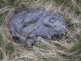
Round Barrow in Swietokrzyskie
A large Bronze Age round barrow of Trzciniec culture is now an island in an arable field. It has 35m in diameter and is 5m high. It is locally known under the name Mogiła.
You may be viewing yesterday's version of this page. To see the most up to date information please register for a free account.
Do not use the above information on other web sites or publications without permission of the contributor.
Nearby Images from Flickr

The above images may not be of the site on this page, but were taken nearby. They are loaded from Flickr so please click on them for image credits.
Click here to see more info for this site
Nearby sites
Click here to view sites on an interactive map of the areaKey: Red: member's photo, Blue: 3rd party photo, Yellow: other image, Green: no photo - please go there and take one, Grey: site destroyed
Download sites to:
KML (Google Earth)
GPX (GPS waypoints)
CSV (Garmin/Navman)
CSV (Excel)
To unlock full downloads you need to sign up as a Contributory Member. Otherwise downloads are limited to 50 sites.
Turn off the page maps and other distractions
Nearby sites listing. In the following links * = Image available
5.6km SSW 193° Kurhan Pałecznica Round Barrow(s)
20.8km E 96° Kurhany Kolosy* Round Barrow(s)
23.1km ESE 118° Kurhan Królewice* Round Barrow(s)
24.4km E 91° Grodzisko Wiślica* Hillfort
27.4km ESE 102° Czarkowy - Kopiec Kościuszki Round Barrow(s)
34.7km ENE 73° Grodzisko Szczaworyż* Hillfort
34.7km ENE 68° Kurhan Żerniki Górne Round Barrow(s)
36.5km SSW 211° Kopiec Wandy* Artificial Mound
41.6km WNW 285° Grodzisko Udórz Hillfort
42.2km S 177° Grodzisko Łapczyca Hillfort
42.3km WSW 243° Jaskinia Wierzchowska Górna* Cave or Rock Shelter
42.5km WSW 242° Jaskinia Mamutowa* Cave or Rock Shelter
43.0km S 188° Kurhan Krakuszowice Round Barrow(s)
43.2km SW 221° Archaeological Museum of Kraków* Museum
43.6km SW 221° Kraków - Wawel* Ancient Village or Settlement
43.9km SW 218° Kopiec Krakusa* Artificial Mound
45.8km SSW 194° Kurhany Jawczyce Barrow Cemetery
46.5km WSW 245° Grodzisko Będkowice* Hillfort
47.8km WNW 282° Smoleń - Zamek Pilcza* Ancient Village or Settlement
48.2km W 280° Jaskinia Na Biśniku Cave or Rock Shelter
50.4km SSE 154° Grodzisko Jadowniki Podgórne* Hillfort
54.7km SW 234° Grodzisko Mników Hillfort
55.0km WSW 246° Grodzisko Bartlowa Góra - Czatkowice Hillfort
57.8km W 263° Grodzisko Stary Olkusz* Hillfort
59.5km SW 228° Wołowice Flint Mine Ancient Mine, Quarry or other Industry
View more nearby sites and additional images


 We would like to know more about this location. Please feel free to add a brief description and any relevant information in your own language.
 Wir möchten mehr über diese Stätte erfahren. Bitte zögern Sie nicht, eine kurze Beschreibung und relevante Informationen in Deutsch hinzuzufügen.
 Nous aimerions en savoir encore un peu sur les lieux. S'il vous plaît n'hesitez pas à ajouter une courte description et tous les renseignements pertinents dans votre propre langue.
 Quisieramos informarnos un poco más de las lugares. No dude en añadir una breve descripción y otros datos relevantes en su propio idioma.