<< Our Photo Pages >> Archeological Outdoor Museum Modrá - Museum in Czech Republic in Moravia
Submitted by ladrin on Wednesday, 04 March 2020 Page Views: 466
MuseumsSite Name: Archeological Outdoor Museum Modrá Alternative Name: Archeoskanzen ModráCountry: Czech Republic
NOTE: This site is 24.867 km away from the location you searched for.
Region: Moravia Type: Museum
Nearest Town: Uherské Hradiště Nearest Village: Velehrad
Latitude: 49.103404N Longitude: 17.406265E
Condition:
| 5 | Perfect |
| 4 | Almost Perfect |
| 3 | Reasonable but with some damage |
| 2 | Ruined but still recognisable as an ancient site |
| 1 | Pretty much destroyed, possibly visible as crop marks |
| 0 | No data. |
| -1 | Completely destroyed |
| 5 | Superb |
| 4 | Good |
| 3 | Ordinary |
| 2 | Not Good |
| 1 | Awful |
| 0 | No data. |
| 5 | Can be driven to, probably with disabled access |
| 4 | Short walk on a footpath |
| 3 | Requiring a bit more of a walk |
| 2 | A long walk |
| 1 | In the middle of nowhere, a nightmare to find |
| 0 | No data. |
| 5 | co-ordinates taken by GPS or official recorded co-ordinates |
| 4 | co-ordinates scaled from a detailed map |
| 3 | co-ordinates scaled from a bad map |
| 2 | co-ordinates of the nearest village |
| 1 | co-ordinates of the nearest town |
| 0 | no data |
Internal Links:
External Links:
")
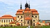
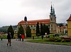
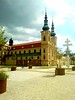
Archeological Outdoor Museum Modrá can be found about 1 km east from one of the most important pilgrimage sites in the Czech Republic. Velehrad was according to the folks tradition, capital of the Slavic state of Great Moravia, thoug this view has little support in historical facts.
The outdoor museum of Modrá, shows the life in the Great Moravian Empire, the first major state of Western Slavs (833-906 AD). Exhibition includes wooden fortifications, guardian towers, replicas of the semi-subterranean buildings, small fields and also areal with wooden Old Slavic idols statues. In the close vicinity of the museum, the foundations of an early Christians church from Great Moravia period are located. Excavated in 1911 and in 50th.
You may be viewing yesterday's version of this page. To see the most up to date information please register for a free account.
")
")
")
")
Do not use the above information on other web sites or publications without permission of the contributor.
Nearby Images from Flickr
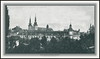
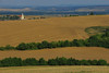
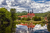
The above images may not be of the site on this page, but were taken nearby. They are loaded from Flickr so please click on them for image credits.
Click here to see more info for this site
Nearby sites
Click here to view sites on an interactive map of the areaKey: Red: member's photo, Blue: 3rd party photo, Yellow: other image, Green: no photo - please go there and take one, Grey: site destroyed
Download sites to:
KML (Google Earth)
GPX (GPS waypoints)
CSV (Garmin/Navman)
CSV (Excel)
To unlock full downloads you need to sign up as a Contributory Member. Otherwise downloads are limited to 50 sites.
Turn off the page maps and other distractions
Nearby sites listing. In the following links * = Image available
4.4km NNW 345° The King's Table* Sculptured Stone
28.4km SSE 161° Javorníky Menhir Standing Stone (Menhir)
37.3km SSW 209° Menhiry Holic* Standing Stones
40.5km SSW 213° Church of Saint Margaret of Antioch, Kopčany* Misc. Earthwork
40.5km N 3° Predmosti* Ancient Village or Settlement
40.6km SW 215° Slavic fortified settlement in Mikulčice* Ancient Village or Settlement
52.0km ESE 116° Roman inscription in Trenčín* Carving
56.5km WNW 294° Býčí skála* Cave or Rock Shelter
58.8km W 280° Moravské zemské muzeum* Museum
58.9km WSW 245° Archeopark Pavlov* Museum
60.0km SW 219° Rabensburg Tumulus (2) Round Barrow(s)
60.6km WSW 247° Dolní Věstonice* Ancient Village or Settlement
61.8km WSW 243° Klentnice Stone Circle* Modern Stone Circle etc
62.0km W 280° Anthropos Pavilion* Museum
62.3km SW 218° Rabensburg Tumuli (1) Round Barrow(s)
62.5km NE 53° Vidče Stone Spheres* Natural Stone / Erratic / Other Natural Feature
84.7km SW 226° MAMUZ Museum Mistelbach* Museum
87.2km SSW 208° Stillfried Zentrum der Urzeit* Museum
88.0km SW 230° MAMUZ Schloss Asparn-Zaya* Museum
95.1km SSW 195° Stupavsky hrad* Hillfort
96.0km NNE 33° Selebice Menhir Standing Stone (Menhir)
102.9km SW 221° Keltenstein Ulrichskirchen* Holed Stone
103.5km WSW 255° Stone stele Hradiste* Standing Stone (Menhir)
103.8km WSW 255° Great Moravia hillfort - Hradiště* Hillfort
103.9km WSW 256° U oveček* Rock Outcrop
View more nearby sites and additional images


 We would like to know more about this location. Please feel free to add a brief description and any relevant information in your own language.
 Wir möchten mehr über diese Stätte erfahren. Bitte zögern Sie nicht, eine kurze Beschreibung und relevante Informationen in Deutsch hinzuzufügen.
 Nous aimerions en savoir encore un peu sur les lieux. S'il vous plaît n'hesitez pas à ajouter une courte description et tous les renseignements pertinents dans votre propre langue.
 Quisieramos informarnos un poco más de las lugares. No dude en añadir una breve descripción y otros datos relevantes en su propio idioma.