


<< Our Photo Pages >> Lakinion Temple of Hera - Ancient Temple in Italy in Calabria
Submitted by AlexHunger on Sunday, 09 September 2007 Page Views: 3891
Roman, Greek and ClassicalSite Name: Lakinion Temple of Hera Alternative Name: CapocolonnaCountry: Italy
NOTE: This site is 11.249 km away from the location you searched for.
Region: Calabria Type: Ancient Temple
Nearest Town: Crotone Nearest Village: Scifo
Latitude: 39.026520N Longitude: 17.204940E
Condition:
| 5 | Perfect |
| 4 | Almost Perfect |
| 3 | Reasonable but with some damage |
| 2 | Ruined but still recognisable as an ancient site |
| 1 | Pretty much destroyed, possibly visible as crop marks |
| 0 | No data. |
| -1 | Completely destroyed |
| 5 | Superb |
| 4 | Good |
| 3 | Ordinary |
| 2 | Not Good |
| 1 | Awful |
| 0 | No data. |
| 5 | Can be driven to, probably with disabled access |
| 4 | Short walk on a footpath |
| 3 | Requiring a bit more of a walk |
| 2 | A long walk |
| 1 | In the middle of nowhere, a nightmare to find |
| 0 | No data. |
| 5 | co-ordinates taken by GPS or official recorded co-ordinates |
| 4 | co-ordinates scaled from a detailed map |
| 3 | co-ordinates scaled from a bad map |
| 2 | co-ordinates of the nearest village |
| 1 | co-ordinates of the nearest town |
| 0 | no data |
Internal Links:
External Links:
")
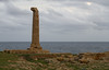
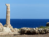
The ancient Greek colony of Kroton was founded by Achaian Greeks in 710 BCE. The sanctuary of Hera was set up just south of the town though only one column of the ancient Greek temple survives at the prominent cape, named after the column. The temple is believed to date to about 470 BCE. The temple largely survived until the 16th Century, when the colonnades were quarried.
You may be viewing yesterday's version of this page. To see the most up to date information please register for a free account.
")
")
")
Do not use the above information on other web sites or publications without permission of the contributor.
Nearby Images from Flickr
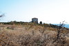
The above images may not be of the site on this page, but were taken nearby. They are loaded from Flickr so please click on them for image credits.
Click here to see more info for this site
Nearby sites
Click here to view sites on an interactive map of the areaKey: Red: member's photo, Blue: 3rd party photo, Yellow: other image, Green: no photo - please go there and take one, Grey: site destroyed
Download sites to:
KML (Google Earth)
GPX (GPS waypoints)
CSV (Garmin/Navman)
CSV (Excel)
To unlock full downloads you need to sign up as a Contributory Member. Otherwise downloads are limited to 50 sites.
Turn off the page maps and other distractions
Nearby sites listing. In the following links * = Image available
41.5km N 353° Krimissa Temple of Apollo Ancient Temple
58.1km WSW 246° Scolacium* Ancient Temple
84.0km SW 220° Museo Archeologico di Monasterace Museum
84.4km SW 220° Kaulonia Ancient Village or Settlement
84.4km SW 220° Caulonia* Ancient Village or Settlement
98.1km NW 322° Sybaris* Ancient Village or Settlement
102.1km WSW 249° Hipponion Temples Ancient Temple
110.6km SW 223° Marina di Gioiosa Jonica* Ancient Village or Settlement
123.7km SW 224° Locri Epizephyrii Ancient Village or Settlement
124.0km SW 223° Locri Epizefiri* Ancient Village or Settlement
125.0km NE 38° Terenzano Menhir* Standing Stone (Menhir)
125.6km NE 37° Ninfeo Menhir Standing Stone (Menhir)
127.1km NE 44° Argentina-Graziadei Dolmen* Burial Chamber or Dolmen
127.8km NE 35° Torre Ospina Dolmen Burial Chamber or Dolmen
129.5km NE 40° Largo Croce Menhir Standing Stone (Menhir)
129.7km NE 40° Visitazione Menhir Standing Stone (Menhir)
131.9km NE 46° Madonna di Costantinopoli Menhir Standing Stone (Menhir)
133.5km NE 46° Mensi Menhir* Standing Stone (Menhir)
133.5km NNW 339° Cugno dei Vagni* Ancient Village or Settlement
134.4km NE 47° Spirito Santo Menhir* Standing Stone (Menhir)
134.9km NE 47° Menhir Della Croce* Standing Stone (Menhir)
137.2km NE 38° Manfio Menhir Standing Stone (Menhir)
140.1km NNW 341° Siritide* Ancient Village or Settlement
141.1km NE 44° Colonna di San Leonardo Menhir* Standing Stone (Menhir)
141.5km NE 38° Coelimanna Menhir* Standing Stone (Menhir)
View more nearby sites and additional images


 We would like to know more about this location. Please feel free to add a brief description and any relevant information in your own language.
 Wir möchten mehr über diese Stätte erfahren. Bitte zögern Sie nicht, eine kurze Beschreibung und relevante Informationen in Deutsch hinzuzufügen.
 Nous aimerions en savoir encore un peu sur les lieux. S'il vous plaît n'hesitez pas à ajouter une courte description et tous les renseignements pertinents dans votre propre langue.
 Quisieramos informarnos un poco más de las lugares. No dude en añadir una breve descripción y otros datos relevantes en su propio idioma.