<< Our Photo Pages >> Valle carvings - Carving in Norway in Nordland
Submitted by kenntha88 on Sunday, 09 December 2007 Page Views: 5133
Multi-periodSite Name: Valle carvings Alternative Name: EfjordCountry: Norway
NOTE: This site is 5.446 km away from the location you searched for.
Fylke: Nordland Type: Carving
Nearest Town: Narvik Nearest Village: Bognes
Latitude: 68.307836N Longitude: 16.304398E
Condition:
| 5 | Perfect |
| 4 | Almost Perfect |
| 3 | Reasonable but with some damage |
| 2 | Ruined but still recognisable as an ancient site |
| 1 | Pretty much destroyed, possibly visible as crop marks |
| 0 | No data. |
| -1 | Completely destroyed |
| 5 | Superb |
| 4 | Good |
| 3 | Ordinary |
| 2 | Not Good |
| 1 | Awful |
| 0 | No data. |
| 5 | Can be driven to, probably with disabled access |
| 4 | Short walk on a footpath |
| 3 | Requiring a bit more of a walk |
| 2 | A long walk |
| 1 | In the middle of nowhere, a nightmare to find |
| 0 | No data. |
| 5 | co-ordinates taken by GPS or official recorded co-ordinates |
| 4 | co-ordinates scaled from a detailed map |
| 3 | co-ordinates scaled from a bad map |
| 2 | co-ordinates of the nearest village |
| 1 | co-ordinates of the nearest town |
| 0 | no data |
Internal Links:
External Links:
")
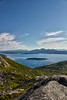
It is far from any populated aeria, I had to take a boat across the fjord to get it, and that was over a very strong current that turned by boat around almost as a clock! That trip was almost hazardous! It is possible to walk on land, but then I would have a 3 days walk across some mountains!
The site contains carvings of two reindeer, two seals and two large fish, and also a beautiful and perfect preserved bear carving. The carvings are "grinded" into the rock, as the ones at Sagelv and Leikens, and are believed to be from the stone age, about 6000-8000 BC.
These are perhaps the best preserved carvings of such an old age in Scandinavia!
They are located in a beautiful mountain landscape with mountain pine trees scattered around, anyone interested in a great nature experience and stone age history should visit this site if possible, it is perhaps the best chance to see stone age carvings closest to the "natural" ancient enviroment.
Note: Nordland county
You may be viewing yesterday's version of this page. To see the most up to date information please register for a free account.
")
")
")
")
Do not use the above information on other web sites or publications without permission of the contributor.
Nearby Images from Flickr
The above images may not be of the site on this page, but were taken nearby. They are loaded from Flickr so please click on them for image credits.
Click here to see more info for this site
Nearby sites
Click here to view sites on an interactive map of the areaKey: Red: member's photo, Blue: 3rd party photo, Yellow: other image, Green: no photo - please go there and take one, Grey: site destroyed
Download sites to:
KML (Google Earth)
GPX (GPS waypoints)
CSV (Garmin/Navman)
CSV (Excel)
To unlock full downloads you need to sign up as a Contributory Member. Otherwise downloads are limited to 50 sites.
Turn off the page maps and other distractions
Nearby sites listing. In the following links * = Image available
6.6km N 350° Storvardhaugen* Cairn
7.2km N 352° Skarstad* Barrow Cemetery
15.8km E 81° Trollsteinen* Natural Stone / Erratic / Other Natural Feature
18.9km WNW 300° Neshaugen-Sør* Rock Art
19.1km WNW 301° Nes-Fort-Øst* Rock Art
19.3km WNW 300° Nes-Fort-Vest* Rock Art
21.4km NW 309° Lødingen* Ancient Village or Settlement
21.6km SSW 211° Leikneset stone carvings* Carving
26.1km SW 221° Ulvsvåg sacrificial stone* Carving
26.4km N 354° Ripelen cairns* Barrow Cemetery
26.4km N 358° Sandsbukta boat houses* Ancient Village or Settlement
26.5km WNW 285° Flåbergan* Rock Art
26.9km N 8° Hol-Tjeldsund Kirke* Round Barrow(s)
27.7km N 358° Tjønneset* Barrow Cemetery
28.0km N 1° Ballstad burial site* Barrow Cemetery
28.0km N 1° Ballstadneset* Standing Stone (Menhir)
35.0km W 277° Hustad* Ancient Village or Settlement
36.6km WNW 297° Husjordøya* Ancient Village or Settlement
38.7km NNE 30° Blåfjell sacrificial site* Natural Stone / Erratic / Other Natural Feature
39.1km SW 228° Oppeid sacrificial site* Stone Circle
39.2km SW 230° Oppeid cairn* Cairn
40.7km N 3° Storjorda sacrificial site* Natural Stone / Erratic / Other Natural Feature
41.3km E 93° Forselv* Carving
48.0km NNW 348° Hemmestad* Standing Stone (Menhir)
48.6km ENE 71° Narvik rock carving* Carving
View more nearby sites and additional images


 We would like to know more about this location. Please feel free to add a brief description and any relevant information in your own language.
 Wir möchten mehr über diese Stätte erfahren. Bitte zögern Sie nicht, eine kurze Beschreibung und relevante Informationen in Deutsch hinzuzufügen.
 Nous aimerions en savoir encore un peu sur les lieux. S'il vous plaît n'hesitez pas à ajouter une courte description et tous les renseignements pertinents dans votre propre langue.
 Quisieramos informarnos un poco más de las lugares. No dude en añadir una breve descripción y otros datos relevantes en su propio idioma.