<< Our Photo Pages >> Megaliti dell'Argimusco - Natural Stone / Erratic / Other Natural Feature in Italy in Sicily (Sicilia)
Submitted by carperano on Friday, 27 November 2015 Page Views: 3340
Natural PlacesSite Name: Megaliti dell'ArgimuscoCountry: Italy
NOTE: This site is 14.23 km away from the location you searched for.
Region: Sicily (Sicilia) Type: Natural Stone / Erratic / Other Natural Feature
Nearest Town: Montalbano Elicona
Latitude: 37.989073N Longitude: 15.041312E
Condition:
| 5 | Perfect |
| 4 | Almost Perfect |
| 3 | Reasonable but with some damage |
| 2 | Ruined but still recognisable as an ancient site |
| 1 | Pretty much destroyed, possibly visible as crop marks |
| 0 | No data. |
| -1 | Completely destroyed |
| 5 | Superb |
| 4 | Good |
| 3 | Ordinary |
| 2 | Not Good |
| 1 | Awful |
| 0 | No data. |
| 5 | Can be driven to, probably with disabled access |
| 4 | Short walk on a footpath |
| 3 | Requiring a bit more of a walk |
| 2 | A long walk |
| 1 | In the middle of nowhere, a nightmare to find |
| 0 | No data. |
| 5 | co-ordinates taken by GPS or official recorded co-ordinates |
| 4 | co-ordinates scaled from a detailed map |
| 3 | co-ordinates scaled from a bad map |
| 2 | co-ordinates of the nearest village |
| 1 | co-ordinates of the nearest town |
| 0 | no data |
Internal Links:
External Links:
")
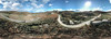
The Argimusco site is situated in the north eastern Sicily between the range Peloritani and Nebrodi on a high plateau near the town of Montalbano Elicona. The origin of the strange shaped megaliths is still debated.
You may be viewing yesterday's version of this page. To see the most up to date information please register for a free account.
")
")
")
Do not use the above information on other web sites or publications without permission of the contributor.
Nearby Images from Flickr
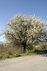
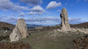
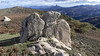
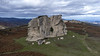
The above images may not be of the site on this page, but were taken nearby. They are loaded from Flickr so please click on them for image credits.
Click here to see more info for this site
Nearby sites
Click here to view sites on an interactive map of the areaKey: Red: member's photo, Blue: 3rd party photo, Yellow: other image, Green: no photo - please go there and take one, Grey: site destroyed
Download sites to:
KML (Google Earth)
GPX (GPS waypoints)
CSV (Garmin/Navman)
CSV (Excel)
To unlock full downloads you need to sign up as a Contributory Member. Otherwise downloads are limited to 50 sites.
Turn off the page maps and other distractions
Nearby sites listing. In the following links * = Image available
7.8km NNE 34° The rocky millstones of Tripi Ancient Mine, Quarry or other Industry
9.2km E 86° Rocca Salvatesta* Rock Outcrop
9.3km E 86° La Valle di Levante* Natural Stone / Erratic / Other Natural Feature
10.2km ENE 68° Rocca Nkravaccada* Natural Stone / Erratic / Other Natural Feature
10.8km E 87° Pizzo Vento* Natural Stone / Erratic / Other Natural Feature
11.6km E 93° Grotta Grottona* Cave or Rock Shelter
17.2km N 0° Tindari* Ancient Village or Settlement
21.5km ENE 67° Rocca Timogna* Rock Outcrop
26.8km SE 125° Taormina* Ancient Village or Settlement
68.4km W 271° Halaesa* Ancient Village or Settlement
70.9km N 1° Panarea Capo Graciano* Ancient Village or Settlement
74.5km NNW 328° Filicudi Island Settlement* Ancient Village or Settlement
79.4km SW 219° Morgantina* Ancient Village or Settlement
88.2km S 172° Megara Hyblaea* Ancient Village or Settlement
89.2km W 274° Cefalu Temple of Artemis* Ancient Temple
93.1km SW 222° Villa imperiale del Casale* Ancient Palace
94.9km S 181° Pantalica Rock Cut Tombs* Rock Cut Tomb
95.0km S 181° The Anaktoron Palace* Ancient Palace
97.9km S 190° The neviere of Buccheri* Artificial Mound
102.5km SW 217° Monte Bubbonia* Chambered Tomb
103.8km SSE 168° Syracuse Archaeological Park* Museum
104.4km S 187° Akrai* Ancient Village or Settlement
104.5km SSE 168° Paolo Orsi Museo Archeologico Museum
104.6km S 187° Santoni* Carving
105.2km SSE 168° Ortigia Temple of Apollo* Ancient Temple
View more nearby sites and additional images


 We would like to know more about this location. Please feel free to add a brief description and any relevant information in your own language.
 Wir möchten mehr über diese Stätte erfahren. Bitte zögern Sie nicht, eine kurze Beschreibung und relevante Informationen in Deutsch hinzuzufügen.
 Nous aimerions en savoir encore un peu sur les lieux. S'il vous plaît n'hesitez pas à ajouter une courte description et tous les renseignements pertinents dans votre propre langue.
 Quisieramos informarnos un poco más de las lugares. No dude en añadir una breve descripción y otros datos relevantes en su propio idioma.