
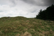

<< Our Photo Pages >> Steinernes Weib - Sculptured Stone in Austria
Submitted by peterpf on Sunday, 30 July 2006 Page Views: 4209
Multi-periodSite Name: Steinernes Weib Alternative Name: Steinernes WeibCountry: Austria
NOTE: This site is 5.459 km away from the location you searched for.
Type: Sculptured Stone
Nearest Town: Weitra
Latitude: 48.701060N Longitude: 14.894150E
Condition:
| 5 | Perfect |
| 4 | Almost Perfect |
| 3 | Reasonable but with some damage |
| 2 | Ruined but still recognisable as an ancient site |
| 1 | Pretty much destroyed, possibly visible as crop marks |
| 0 | No data. |
| -1 | Completely destroyed |
| 5 | Superb |
| 4 | Good |
| 3 | Ordinary |
| 2 | Not Good |
| 1 | Awful |
| 0 | No data. |
| 5 | Can be driven to, probably with disabled access |
| 4 | Short walk on a footpath |
| 3 | Requiring a bit more of a walk |
| 2 | A long walk |
| 1 | In the middle of nowhere, a nightmare to find |
| 0 | No data. |
| 5 | co-ordinates taken by GPS or official recorded co-ordinates |
| 4 | co-ordinates scaled from a detailed map |
| 3 | co-ordinates scaled from a bad map |
| 2 | co-ordinates of the nearest village |
| 1 | co-ordinates of the nearest town |
| 0 | no data |
Internal Links:
External Links:
")
This board next to the stones tells several legends:
the first says: the stone is a remainder an a woman, who was killed by wolves in 1664.
the next is about a woman how was changed into a stone by lightning.
For the 3rd one a woman was changed into stone as punishment.
the last one assumes this stone as a border-stone.
You may be viewing yesterday's version of this page. To see the most up to date information please register for a free account.
")
")
")
Do not use the above information on other web sites or publications without permission of the contributor.
Nearby Images from Flickr


The above images may not be of the site on this page, but were taken nearby. They are loaded from Flickr so please click on them for image credits.
Click here to see more info for this site
Nearby sites
Click here to view sites on an interactive map of the areaKey: Red: member's photo, Blue: 3rd party photo, Yellow: other image, Green: no photo - please go there and take one, Grey: site destroyed
Download sites to:
KML (Google Earth)
GPX (GPS waypoints)
CSV (Garmin/Navman)
CSV (Excel)
To unlock full downloads you need to sign up as a Contributory Member. Otherwise downloads are limited to 50 sites.
Turn off the page maps and other distractions
Nearby sites listing. In the following links * = Image available
10.9km SSE 159° Kierlingstein* Natural Stone / Erratic / Other Natural Feature
11.3km NE 43° Teufelsbett Blockheide* Natural Stone / Erratic / Other Natural Feature
11.3km NE 43° Teufelsbrotlaib* Natural Stone / Erratic / Other Natural Feature
11.3km NE 43° Schuldstein* Natural Stone / Erratic / Other Natural Feature
11.4km NE 43° Schwedenkreuz* Ancient Cross
11.5km NE 40° Koboldsteine* Natural Stone / Erratic / Other Natural Feature
11.5km NE 40° Wackelstein I Blockheide* Natural Stone / Erratic / Other Natural Feature
11.5km NE 45° Cristophstein* Natural Stone / Erratic / Other Natural Feature
11.6km NE 40° Pyramidenstein* Natural Stone / Erratic / Other Natural Feature
11.6km NE 45° Wackelstein II Blockheide* Natural Stone / Erratic / Other Natural Feature
11.7km ESE 111° Summstein Thaya* Modern Stone Circle etc
11.7km NE 37° Hausstein* Natural Stone / Erratic / Other Natural Feature
11.9km NE 37° Eibenstein* Natural Stone / Erratic / Other Natural Feature
11.9km NE 43° Wackelstein III Blockheide* Natural Stone / Erratic / Other Natural Feature
12.1km NE 43° Pilzstein* Natural Stone / Erratic / Other Natural Feature
14.1km SSE 162° Thail Opferstein* Natural Stone / Erratic / Other Natural Feature
14.1km SSE 162° Summstein Thail* Modern Stone Circle etc
14.5km SE 143° Weltkugel* Natural Stone / Erratic / Other Natural Feature
16.0km S 173° Wackelstein bei Harruck* Natural Stone / Erratic / Other Natural Feature
18.6km SE 138° Gross Gerungs Steinpyramide* Pyramid / Mastaba
19.7km NE 44° Wackelstein in Amaliendorf* Natural Stone / Erratic / Other Natural Feature
22.8km NE 55° Wolfsegg* Sculptured Stone
24.9km NE 47° Hängender Stein* Natural Stone / Erratic / Other Natural Feature
29.1km NNE 32° Kolomanistein* Natural Stone / Erratic / Other Natural Feature
29.9km W 260° U svatého Kamene* Sculptured Stone
View more nearby sites and additional images


 We would like to know more about this location. Please feel free to add a brief description and any relevant information in your own language.
 Wir möchten mehr über diese Stätte erfahren. Bitte zögern Sie nicht, eine kurze Beschreibung und relevante Informationen in Deutsch hinzuzufügen.
 Nous aimerions en savoir encore un peu sur les lieux. S'il vous plaît n'hesitez pas à ajouter une courte description et tous les renseignements pertinents dans votre propre langue.
 Quisieramos informarnos un poco más de las lugares. No dude en añadir una breve descripción y otros datos relevantes en su propio idioma.