<< Text Pages >> Lochstein Wuggitz - Holed Stone in Austria
Submitted by KaiHofmann on Thursday, 10 July 2014 Page Views: 3006
Neolithic and Bronze AgeSite Name: Lochstein WuggitzCountry: Austria
NOTE: This site is 26.843 km away from the location you searched for.
Type: Holed Stone
Nearest Town: Deutschlandsberg Nearest Village: Wuggitz
Latitude: 46.680426N Longitude: 15.293252E
Condition:
| 5 | Perfect |
| 4 | Almost Perfect |
| 3 | Reasonable but with some damage |
| 2 | Ruined but still recognisable as an ancient site |
| 1 | Pretty much destroyed, possibly visible as crop marks |
| 0 | No data. |
| -1 | Completely destroyed |
| 5 | Superb |
| 4 | Good |
| 3 | Ordinary |
| 2 | Not Good |
| 1 | Awful |
| 0 | No data. |
| 5 | Can be driven to, probably with disabled access |
| 4 | Short walk on a footpath |
| 3 | Requiring a bit more of a walk |
| 2 | A long walk |
| 1 | In the middle of nowhere, a nightmare to find |
| 0 | No data. |
| 5 | co-ordinates taken by GPS or official recorded co-ordinates |
| 4 | co-ordinates scaled from a detailed map |
| 3 | co-ordinates scaled from a bad map |
| 2 | co-ordinates of the nearest village |
| 1 | co-ordinates of the nearest town |
| 0 | no data |
Internal Links:
External Links:
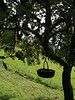
Holed Stone in Austria
Holed stone on a private farm ground. Excact position unknown.
You may be viewing yesterday's version of this page. To see the most up to date information please register for a free account.
Do not use the above information on other web sites or publications without permission of the contributor.
Nearby Images from Flickr
The above images may not be of the site on this page, but were taken nearby. They are loaded from Flickr so please click on them for image credits.
Click here to see more info for this site
Nearby sites
Click here to view sites on an interactive map of the areaKey: Red: member's photo, Blue: 3rd party photo, Yellow: other image, Green: no photo - please go there and take one, Grey: site destroyed
Download sites to:
KML (Google Earth)
GPX (GPS waypoints)
CSV (Garmin/Navman)
CSV (Excel)
To unlock full downloads you need to sign up as a Contributory Member. Otherwise downloads are limited to 50 sites.
Turn off the page maps and other distractions
Nearby sites listing. In the following links * = Image available
27.1km ESE 116° The Devil Stones (Maribor)* Natural Stone / Erratic / Other Natural Feature
60.5km N 4° Römerweg Badl Ancient Trackway
61.1km N 4° Repolusthöhle Cave or Rock Shelter
72.1km SE 142° Krapina Cave and Neanderthal Museum* Cave or Rock Shelter
86.8km SW 219° Čolnišče Prehistoric Trap* Ancient Village or Settlement
87.4km NNE 32° Pongratzen Menhir Standing Stone (Menhir)
88.4km NE 34° Lochstein (Stambach) Holed Stone
89.5km ESE 117° Varazdin Museum* Museum
90.9km NNE 24° Lochstein (Wenigzell) Holed Stone
93.6km NNE 32° Lochstein Kleinschlag Holed Stone
97.9km W 264° Keltenwelt Froeg-Rosegg Museum
110.1km SSE 151° Zagreb Archeological Museum* Museum
115.0km NE 50° Hat Rock (Kalapos-kő)* Rock Outcrop
130.8km NW 326° In der Höll petroglyphs Rock Art
133.5km NE 37° Keltendorf Schwarzenbach Museum
133.7km NE 37° Keltenwall Schwarzenbach Hillfort
143.9km NW 309° Notgasse Petroglyphen Rock Art
153.8km SW 231° Debela Griža Hillfort
154.8km W 279° Schalenstein Danielsberg Rock Art
156.9km SSE 148° Sisak Ancient Village or Settlement
158.4km NW 309° Hallstatt-Dachstein* Barrow Cemetery
158.4km NW 309° Museum Hallstatt* Museum
158.9km NNE 21° Peilstein Berg Natural Stone / Erratic / Other Natural Feature
159.0km NW 309° Hallstatt Salt Mines* Ancient Mine, Quarry or other Industry
159.0km NNE 20° Hafnerberg Lochstein 1 Holed Stone
View more nearby sites and additional images


 We would like to know more about this location. Please feel free to add a brief description and any relevant information in your own language.
 Wir möchten mehr über diese Stätte erfahren. Bitte zögern Sie nicht, eine kurze Beschreibung und relevante Informationen in Deutsch hinzuzufügen.
 Nous aimerions en savoir encore un peu sur les lieux. S'il vous plaît n'hesitez pas à ajouter une courte description et tous les renseignements pertinents dans votre propre langue.
 Quisieramos informarnos un poco más de las lugares. No dude en añadir una breve descripción y otros datos relevantes en su propio idioma.