<< Our Photo Pages >> Mirabib - Natural Stone / Erratic / Other Natural Feature in Namibia
Submitted by KaiHofmann on Tuesday, 25 May 2010 Page Views: 7682
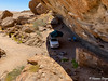
Natural PlacesSite Name: Mirabib Alternative Name: Mirabib RockCountry: Namibia
NOTE: This site is 103.754 km away from the location you searched for.
Type: Natural Stone / Erratic / Other Natural Feature
Nearest Town: Walvis Bay Nearest Village: Rostock Farm
Latitude: 23.4541S Longitude: 15.353300E
Condition:
| 5 | Perfect |
| 4 | Almost Perfect |
| 3 | Reasonable but with some damage |
| 2 | Ruined but still recognisable as an ancient site |
| 1 | Pretty much destroyed, possibly visible as crop marks |
| 0 | No data. |
| -1 | Completely destroyed |
| 5 | Superb |
| 4 | Good |
| 3 | Ordinary |
| 2 | Not Good |
| 1 | Awful |
| 0 | No data. |
| 5 | Can be driven to, probably with disabled access |
| 4 | Short walk on a footpath |
| 3 | Requiring a bit more of a walk |
| 2 | A long walk |
| 1 | In the middle of nowhere, a nightmare to find |
| 0 | No data. |
| 5 | co-ordinates taken by GPS or official recorded co-ordinates |
| 4 | co-ordinates scaled from a detailed map |
| 3 | co-ordinates scaled from a bad map |
| 2 | co-ordinates of the nearest village |
| 1 | co-ordinates of the nearest town |
| 0 | no data |
Internal Links:
External Links:
")
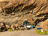
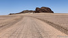
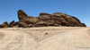
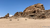
Stanley Kubrick filmed here part 1, "the dawn of mankind" of the movie "2001- A Space Odyssey".
It´s an awesome place in the middle of nowhere.
You may be viewing yesterday's version of this page. To see the most up to date information please register for a free account.
")
")
Do not use the above information on other web sites or publications without permission of the contributor.
Nearby Images from Flickr

The above images may not be of the site on this page, but were taken nearby. They are loaded from Flickr so please click on them for image credits.
Click here to see more info for this site
Nearby sites
Click here to view sites on an interactive map of the areaKey: Red: member's photo, Blue: 3rd party photo, Yellow: other image, Green: no photo - please go there and take one, Grey: site destroyed
Download sites to:
KML (Google Earth)
GPX (GPS waypoints)
CSV (Garmin/Navman)
CSV (Excel)
To unlock full downloads you need to sign up as a Contributory Member. Otherwise downloads are limited to 50 sites.
Turn off the page maps and other distractions
Nearby sites listing. In the following links * = Image available
79.0km ENE 67° Rooisand Rock Painting* Rock Art
181.8km N 355° Bushman Paradise* Rock Art
186.3km N 9° Phillipp's Cave Rock Art
196.7km NNE 19° Paula's Cave Rock Art
222.8km NNE 32° Oropoko* Rock Art
270.1km NNW 345° The White Lady Group* Rock Art
333.2km NNW 342° Twyfelfontein* Stone Circle
333.5km NNW 342° Twyfelfontein* Rock Art
337.2km N 2° Omburo Ost* Rock Art
341.6km N 1° Vingerklip* Natural Stone / Erratic / Other Natural Feature
505.0km SSE 160° Apollo 11 Cave* Cave or Rock Shelter
556.7km SE 132° The Lost City of Kalahari* Ancient Village or Settlement
625.6km SSE 165° Spitzkloof* Cave or Rock Shelter
767.5km NNW 343° Pinturas Rupestres do Monte Negro Rock Art
843.6km NE 53° Tsodilo Hills* Rock Art
874.8km NNW 342° Tshitundo Hulo Rock Art
904.6km ESE 123° Kathu Pan* Ancient Mine, Quarry or other Industry
955.7km ESE 122° Wonderwerk Cave* Cave or Rock Shelter
1038.8km SSE 164° Diepkloof* Rock Outcrop
1048.4km N 352° Quilengues Gravures Rupestres Rock Art
1060.1km NNW 348° Txipopilu Petroglyphs Rock Art
1060.6km ENE 74° Makgadikgadi* Ancient Village or Settlement
1076.8km SE 126° Driekopseiland Rock Art Rock Art
1086.8km ESE 124° Nooitgedacht Rock art Rock Art
1094.2km SE 124° Wildebeestkuil* Rock Art
View more nearby sites and additional images


 We would like to know more about this location. Please feel free to add a brief description and any relevant information in your own language.
 Wir möchten mehr über diese Stätte erfahren. Bitte zögern Sie nicht, eine kurze Beschreibung und relevante Informationen in Deutsch hinzuzufügen.
 Nous aimerions en savoir encore un peu sur les lieux. S'il vous plaît n'hesitez pas à ajouter une courte description et tous les renseignements pertinents dans votre propre langue.
 Quisieramos informarnos un poco más de las lugares. No dude en añadir una breve descripción y otros datos relevantes en su propio idioma.