

<< Our Photo Pages >> Boží skála - Standing Stone (Menhir) in Czech Republic in Bohemia
Submitted by ladrin on Friday, 25 December 2015 Page Views: 3968
Neolithic and Bronze AgeSite Name: Boží skála Alternative Name: God's RockCountry: Czech Republic
NOTE: This site is 8.901 km away from the location you searched for.
Region: Bohemia Type: Standing Stone (Menhir)
Nearest Town: Jílové u Prahy Nearest Village: Kabáty
Latitude: 49.890419N Longitude: 14.502149E
Condition:
| 5 | Perfect |
| 4 | Almost Perfect |
| 3 | Reasonable but with some damage |
| 2 | Ruined but still recognisable as an ancient site |
| 1 | Pretty much destroyed, possibly visible as crop marks |
| 0 | No data. |
| -1 | Completely destroyed |
| 5 | Superb |
| 4 | Good |
| 3 | Ordinary |
| 2 | Not Good |
| 1 | Awful |
| 0 | No data. |
| 5 | Can be driven to, probably with disabled access |
| 4 | Short walk on a footpath |
| 3 | Requiring a bit more of a walk |
| 2 | A long walk |
| 1 | In the middle of nowhere, a nightmare to find |
| 0 | No data. |
| 5 | co-ordinates taken by GPS or official recorded co-ordinates |
| 4 | co-ordinates scaled from a detailed map |
| 3 | co-ordinates scaled from a bad map |
| 2 | co-ordinates of the nearest village |
| 1 | co-ordinates of the nearest town |
| 0 | no data |
Internal Links:
External Links:
")
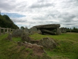
Its position between the old trees creates a place of awesome atmosphere. The stone stands just a few steps from the little summit where unnatural looking terrain and rock formations can be found.
You may be viewing yesterday's version of this page. To see the most up to date information please register for a free account.
")
")
")
")
")
")
")
")
Do not use the above information on other web sites or publications without permission of the contributor.
Click here to see more info for this site
Nearby sites
Click here to view sites on an interactive map of the areaKey: Red: member's photo, Blue: 3rd party photo, Yellow: other image, Green: no photo - please go there and take one, Grey: site destroyed
Download sites to:
KML (Google Earth)
GPX (GPS waypoints)
CSV (Garmin/Navman)
CSV (Excel)
To unlock full downloads you need to sign up as a Contributory Member. Otherwise downloads are limited to 50 sites.
Turn off the page maps and other distractions
Nearby sites listing. In the following links * = Image available
1.2km NE 34° Chotouň Standing stone* Standing Stone (Menhir)
2.3km ESE 114° Kněží Hora* Standing Stones
2.5km ESE 114° Dolmen na Kněží Hoře* Modern Stone Circle etc
2.5km SE 134° Řada Vlčí rokle* Stone Row / Alignment
8.4km S 189° Větrov Modern Megaliths* Modern Stone Circle etc
10.5km NW 320° Oppidum Závist* Hillfort
10.9km NW 326° Šance (Ramparts)* Hillfort
18.9km SSW 202° Oppidum Hrazany* Hillfort
18.9km S 186° Stone Face of Křečovice* Sculptured Stone
19.9km NNW 344° Stone of the New birth* Standing Stone (Menhir)
20.1km NNW 343° Rotunda Stone* Standing Stone (Menhir)
20.2km NNW 343° Vysehrad Devil's stone* Standing Stone (Menhir)
20.3km NNW 343° Menhir in Karlach Park* Standing Stone (Menhir)
20.3km NNW 343° Basilica Stone* Standing Stone (Menhir)
20.4km NE 43° Prehistoric hillfort Březí* Hillfort
21.4km NW 313° Zbuzany Stone* Standing Stone (Menhir)
21.8km SE 140° Menhir Líšno* Standing Stone (Menhir)
23.2km NNW 343° Libenice Stela* Standing Stone (Menhir)
23.4km NNW 342° Prague Castle Obelisk* Modern Stone Circle etc
23.4km NNW 340° Prague's stone* Standing Stone (Menhir)
25.0km NNW 343° Terrronská St. Long Houses* Ancient Village or Settlement
26.0km SSW 209° Kamenné řady Líchovy* Stone Row / Alignment
26.1km SSW 209° Líchovy Stones* Standing Stones
26.6km NE 37° Úvaly Stonehenge* Modern Stone Circle etc
27.6km WNW 289° St. John Rock* Cave or Rock Shelter
View more nearby sites and additional images


 We would like to know more about this location. Please feel free to add a brief description and any relevant information in your own language.
 Wir möchten mehr über diese Stätte erfahren. Bitte zögern Sie nicht, eine kurze Beschreibung und relevante Informationen in Deutsch hinzuzufügen.
 Nous aimerions en savoir encore un peu sur les lieux. S'il vous plaît n'hesitez pas à ajouter une courte description et tous les renseignements pertinents dans votre propre langue.
 Quisieramos informarnos un poco más de las lugares. No dude en añadir una breve descripción y otros datos relevantes en su propio idioma.