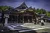
<< Our Photo Pages >> Jōsen-ji temple - Modern Stone Circle etc in Japan in Honshū
Submitted by Aska on Sunday, 26 January 2020 Page Views: 558
Modern SitesSite Name: Jōsen-ji temple Alternative Name: 浄泉寺 Josen-jiCountry: Japan
NOTE: This site is 25.442 km away from the location you searched for.
Region: Honshū Type: Modern Stone Circle etc
Nearest Town: Niigata (Niigata prefecture) Nearest Village: Ishize 石瀬
Latitude: 37.722140N Longitude: 138.837020E
Condition:
| 5 | Perfect |
| 4 | Almost Perfect |
| 3 | Reasonable but with some damage |
| 2 | Ruined but still recognisable as an ancient site |
| 1 | Pretty much destroyed, possibly visible as crop marks |
| 0 | No data. |
| -1 | Completely destroyed |
| 5 | Superb |
| 4 | Good |
| 3 | Ordinary |
| 2 | Not Good |
| 1 | Awful |
| 0 | No data. |
| 5 | Can be driven to, probably with disabled access |
| 4 | Short walk on a footpath |
| 3 | Requiring a bit more of a walk |
| 2 | A long walk |
| 1 | In the middle of nowhere, a nightmare to find |
| 0 | No data. |
| 5 | co-ordinates taken by GPS or official recorded co-ordinates |
| 4 | co-ordinates scaled from a detailed map |
| 3 | co-ordinates scaled from a bad map |
| 2 | co-ordinates of the nearest village |
| 1 | co-ordinates of the nearest town |
| 0 | no data |
Internal Links:
External Links:
")
A temple in a small village located at the southern outskirts of Niigata city has a fine dry landscape garden.
You may be viewing yesterday's version of this page. To see the most up to date information please register for a free account.
Do not use the above information on other web sites or publications without permission of the contributor.
Nearby Images from Flickr

The above images may not be of the site on this page, but were taken nearby. They are loaded from Flickr so please click on them for image credits.
Click here to see more info for this site
Nearby sites
Click here to view sites on an interactive map of the areaKey: Red: member's photo, Blue: 3rd party photo, Yellow: other image, Green: no photo - please go there and take one, Grey: site destroyed
Download sites to:
KML (Google Earth)
GPX (GPS waypoints)
CSV (Garmin/Navman)
CSV (Excel)
To unlock full downloads you need to sign up as a Contributory Member. Otherwise downloads are limited to 50 sites.
Turn off the page maps and other distractions
Nearby sites listing. In the following links * = Image available
46.5km NW 308° Chōkoku-ji temple* Modern Stone Circle etc
52.0km ESE 106° Kosegasawa Cave Cave or Rock Shelter
65.1km S 186° Kurinokida* Stone Circle
85.1km E 98° Nagai MaenoYama Kofun* Long Barrow
90.0km NE 50° Achiyadaira* Stone Circle
102.0km SSW 202° Waguri Kofun* Passage Grave
103.5km SSW 201° Oni-no Kama Kofun* Chambered Cairn
103.5km SSW 202° Asahi Gōro Kofun* Chambered Cairn
104.0km SSW 202° Nezuka Iseki* Chambered Cairn
114.7km S 174° Yaze* Ancient Village or Settlement
115.0km SSW 202° Hayashiguro Kofun* Passage Grave
115.5km SW 228° Chōjagahara* Ancient Village or Settlement
118.6km SSW 201° Kingaizan Kofun* Chambered Cairn
119.4km SW 230° Teraji* Timber Circle
122.2km SSW 201° Ganshōin Kofungun* Chambered Cairn
123.3km SSW 202° Tonobayashi Kofungun* Chambered Cairn
123.9km SSW 201° Sotofudō Kofungun* Chambered Cairn
124.2km SSW 202° Rokusendō Nishioki Kofungun* Chambered Cairn
124.2km SSW 202° Tambazuka Kofun* Chambered Cairn
124.2km SSW 201° Kuchimyōzuka Kofungun* Chambered Cairn
124.6km ENE 73° Matsuzawa kofungun* Chambered Cairn
124.9km SSW 205° Yoshi Kofungun* Passage Grave
125.1km SSW 201° Sakaizuka Kofun* Chambered Cairn
125.6km S 174° Gunma Astronomical Observatory* Modern Stone Circle etc
126.0km SSW 201° Urushizuka Kofungun* Chambered Cairn
View more nearby sites and additional images


 We would like to know more about this location. Please feel free to add a brief description and any relevant information in your own language.
 Wir möchten mehr über diese Stätte erfahren. Bitte zögern Sie nicht, eine kurze Beschreibung und relevante Informationen in Deutsch hinzuzufügen.
 Nous aimerions en savoir encore un peu sur les lieux. S'il vous plaît n'hesitez pas à ajouter une courte description et tous les renseignements pertinents dans votre propre langue.
 Quisieramos informarnos un poco más de las lugares. No dude en añadir una breve descripción y otros datos relevantes en su propio idioma.