<< Other Photo Pages >> Nala Stone Men - Modern Stone Circle etc in Australia
Submitted by Andy B on Thursday, 18 January 2024 Page Views: 34965
Modern SitesSite Name: Nala Stone MenCountry: Australia Type: Modern Stone Circle etc
Nearest Town: Peterborough
Latitude: 31.45849S Longitude: 138.736140E
Condition:
| 5 | Perfect |
| 4 | Almost Perfect |
| 3 | Reasonable but with some damage |
| 2 | Ruined but still recognisable as an ancient site |
| 1 | Pretty much destroyed, possibly visible as crop marks |
| 0 | No data. |
| -1 | Completely destroyed |
| 5 | Superb |
| 4 | Good |
| 3 | Ordinary |
| 2 | Not Good |
| 1 | Awful |
| 0 | No data. |
| 5 | Can be driven to, probably with disabled access |
| 4 | Short walk on a footpath |
| 3 | Requiring a bit more of a walk |
| 2 | A long walk |
| 1 | In the middle of nowhere, a nightmare to find |
| 0 | No data. |
| 5 | co-ordinates taken by GPS or official recorded co-ordinates |
| 4 | co-ordinates scaled from a detailed map |
| 3 | co-ordinates scaled from a bad map |
| 2 | co-ordinates of the nearest village |
| 1 | co-ordinates of the nearest town |
| 0 | no data |
Internal Links:
External Links:
")
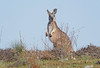
I don't know the location of where the Stone Men were constructed for filming, or anything remains of them - do you? Please leave a comment if you do and I will update the location on our map.
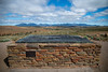
For this reason I have chosen a well known lookout spot in the Flinders Ranges which might be a good starting point. Stokes Hill Lookout is accessed approximately 20km north of the Wilpena Pound Resort turn off on the Flinders Ranges Way.
The Tourist was written by Jack and Harry Williams (The Missing, Baptiste, Liar), the story follows a Northern Irishman who wakes up in the Australian Outback with amnesia following a car crash. As he tries to piece his life together, he quickly realises someone is after him and wants him dead.
Where was the TV thriller The Tourist filmed?
Australian mountain range Flinders Ranges features in The Tourist, with the production building a petrol station in that part of the outback.
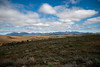
Located approximately 125 miles north of Adelaide, the range stretches over 430km, with parts of the land being given protected area status including the Ikara-Flinders Ranges National Park and the Mount Remarkable National Park.
The South Australian town of Peterborough provided a backdrop for some episodes of The Tourist, located just off of the Barrier Highway. The town is mostly remote and sparsely populated, providing an unforgiving landscape as the perfect setting for a man struggling with amnesia.
The Tourist locations: Is Burnt Ridge a real place?
Much of the action in the BBC drama The Tourist centres around an area called Burnt Ridge. In fact, Burnt Ridge is a fictional town in South Australia.
With many thanks to Radio Times - more filming locations for The Tourist are described in their article: http://www.radiotimes.com/tv/drama/the-tourist-bbc-one-filming-locations/
I don't know the location of where the Nala Stone Men were constructed for filming, or anything remains of them - do you? Please leave a comment if you do and I will update the location on our map.
You may be viewing yesterday's version of this page. To see the most up to date information please register for a free account.
")
Do not use the above information on other web sites or publications without permission of the contributor.
Nearby Images from Flickr

The above images may not be of the site on this page, but were taken nearby. They are loaded from Flickr so please click on them for image credits.
Click here to see more info for this site
Nearby sites
Click here to view sites on an interactive map of the areaKey: Red: member's photo, Blue: 3rd party photo, Yellow: other image, Green: no photo - please go there and take one, Grey: site destroyed
Download sites to:
KML (Google Earth)
GPX (GPS waypoints)
CSV (Garmin/Navman)
CSV (Excel)
To unlock full downloads you need to sign up as a Contributory Member. Otherwise downloads are limited to 50 sites.
Turn off the page maps and other distractions
Nearby sites listing. In the following links * = Image available
48.4km NW 318° Warratyi* Cave or Rock Shelter
478.4km ESE 123° Mungo, Australia* Ancient Village or Settlement
633.5km E 89° 25-3-0057 Stone Row / Alignment
732.5km SSE 166° Mount Gambier* Ancient Mine, Quarry or other Industry
750.5km E 87° 17-1-0006 Stone Row / Alignment
839.8km W 268° Koonalda Cave Cave or Rock Shelter
841.4km E 91° 27-2-0004 Stone Row / Alignment
886.6km SE 145° Wurdi Youang* Stone Row / Alignment
903.7km SSE 147° Geelong Stone Setting Standing Stones
941.6km NW 323° Henbury Meteorite Craters* Natural Stone / Erratic / Other Natural Feature
1000.3km ESE 109° 51-1-0053 Stone Row / Alignment
1002.6km E 92° 28-2-0005 Stone Row / Alignment
1014.1km NW 310° Ayers Rock* Rock Art
1056.9km ESE 120° 57-4-0209 Stone Row / Alignment
1063.1km ESE 124° Jindabyne rock walls Stone Row / Alignment
1070.7km SE 126° 62-4-0127 Stone Row / Alignment
1071.0km ESE 105° 44-6-0019 Stone Row / Alignment
1108.9km ESE 112° 51-6-0250 Stone Row / Alignment
1124.6km ESE 106° Lawson Engraving Site* Rock Art
1131.7km ESE 106° Faulconbridge Emus Rock Art
1153.1km E 100° 37-5-0206 Stone Row / Alignment
1164.6km E 101° 37-6-0471 Stone Row / Alignment
1165.3km ESE 110° 52-2-2245 Stone Row / Alignment
1165.6km ESE 102° Wollemi National Park Rock Art Rock Art
1165.6km E 87° 20-2-0005 Stone Row / Alignment
View more nearby sites and additional images


 We would like to know more about this location. Please feel free to add a brief description and any relevant information in your own language.
 Wir möchten mehr über diese Stätte erfahren. Bitte zögern Sie nicht, eine kurze Beschreibung und relevante Informationen in Deutsch hinzuzufügen.
 Nous aimerions en savoir encore un peu sur les lieux. S'il vous plaît n'hesitez pas à ajouter une courte description et tous les renseignements pertinents dans votre propre langue.
 Quisieramos informarnos un poco más de las lugares. No dude en añadir una breve descripción y otros datos relevantes en su propio idioma.