

<< Our Photo Pages >> Teraji - Timber Circle in Japan in Honshū
Submitted by Aska on Sunday, 25 July 2010 Page Views: 3358
Neolithic and Bronze AgeSite Name: Teraji Alternative Name: 寺地Country: Japan
NOTE: This site is 33.731 km away from the location you searched for.
Region: Honshū Type: Timber Circle
Nearest Town: Itoigawa (Niigata pref.) Nearest Village: Teraji 寺地
Latitude: 37.025090N Longitude: 137.809490E
Condition:
| 5 | Perfect |
| 4 | Almost Perfect |
| 3 | Reasonable but with some damage |
| 2 | Ruined but still recognisable as an ancient site |
| 1 | Pretty much destroyed, possibly visible as crop marks |
| 0 | No data. |
| -1 | Completely destroyed |
| 5 | Superb |
| 4 | Good |
| 3 | Ordinary |
| 2 | Not Good |
| 1 | Awful |
| 0 | No data. |
| 5 | Can be driven to, probably with disabled access |
| 4 | Short walk on a footpath |
| 3 | Requiring a bit more of a walk |
| 2 | A long walk |
| 1 | In the middle of nowhere, a nightmare to find |
| 0 | No data. |
| 5 | co-ordinates taken by GPS or official recorded co-ordinates |
| 4 | co-ordinates scaled from a detailed map |
| 3 | co-ordinates scaled from a bad map |
| 2 | co-ordinates of the nearest village |
| 1 | co-ordinates of the nearest town |
| 0 | no data |
Internal Links:
External Links:
")
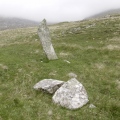
On the roadside, this ruin of an ancient village is situated as a prehistorical park. The ruin contains a reconstructed house, a timber circle and a jade working studio. Itoigawa is known as the jade-producing area.
You may be viewing yesterday's version of this page. To see the most up to date information please register for a free account.
Do not use the above information on other web sites or publications without permission of the contributor.
Nearby Images from Flickr
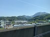
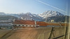
The above images may not be of the site on this page, but were taken nearby. They are loaded from Flickr so please click on them for image credits.
Click here to see more info for this site
Nearby sites
Click here to view sites on an interactive map of the areaKey: Red: member's photo, Blue: 3rd party photo, Yellow: other image, Green: no photo - please go there and take one, Grey: site destroyed
Download sites to:
KML (Google Earth)
GPX (GPS waypoints)
CSV (Garmin/Navman)
CSV (Excel)
To unlock full downloads you need to sign up as a Contributory Member. Otherwise downloads are limited to 50 sites.
Turn off the page maps and other distractions
Nearby sites listing. In the following links * = Image available
4.9km E 87° Chōjagahara* Ancient Village or Settlement
51.9km SE 144° Yoshimizu Kofun* Passage Grave
52.2km SE 133° Yoshi Kofungun* Passage Grave
52.4km SE 142° Futagozuka Kofun (in Nagano)* Chambered Cairn
54.7km S 178° Shingō Kofungun* Chambered Cairn
55.8km ESE 121° Hayashiguro Kofun* Passage Grave
55.9km ESE 110° Nezuka Iseki* Chambered Cairn
56.0km S 180° Wappara* Stone Circle
56.2km ESE 109° Asahi Gōro Kofun* Chambered Cairn
56.7km ESE 108° Waguri Kofun* Passage Grave
56.8km ESE 109° Oni-no Kama Kofun* Chambered Cairn
57.9km SSE 153° Ike-no-ue Kofun* Chambered Cairn
58.7km SE 130° Rokusendō Nishioki Kofungun* Chambered Cairn
58.9km SSE 154° Tsuruhagi Kofun* Chambered Cairn
59.3km SE 128° Ganshōin Kofungun* Chambered Cairn
59.3km SE 129° Tonobayashi Kofungun* Chambered Cairn
59.6km SE 130° Tambazuka Kofun* Chambered Cairn
59.7km SE 124° Kingaizan Kofun* Chambered Cairn
59.8km SE 129° Sotofudō Kofungun* Chambered Cairn
60.0km SE 129° Kuchimyōzuka Kofungun* Chambered Cairn
60.1km SE 139° Kitano Museum of Art* Modern Stone Circle etc
60.9km SE 135° Tenjin Kofungun* Chambered Cairn
60.9km SE 131° GyōninZuka Kofun* Chambered Cairn
61.1km SE 135° Yonamochi Tenjin Kofun* Chambered Cairn
61.2km SE 130° Sakaizuka Kofun* Chambered Cairn
View more nearby sites and additional images


 We would like to know more about this location. Please feel free to add a brief description and any relevant information in your own language.
 Wir möchten mehr über diese Stätte erfahren. Bitte zögern Sie nicht, eine kurze Beschreibung und relevante Informationen in Deutsch hinzuzufügen.
 Nous aimerions en savoir encore un peu sur les lieux. S'il vous plaît n'hesitez pas à ajouter une courte description et tous les renseignements pertinents dans votre propre langue.
 Quisieramos informarnos un poco más de las lugares. No dude en añadir una breve descripción y otros datos relevantes en su propio idioma.