

<< Our Photo Pages >> Tsukumozuka - Artificial Mound in Japan in Kyūshū
Submitted by Aska on Saturday, 01 November 2014 Page Views: 1567
Date UncertainSite Name: Tsukumozuka Alternative Name: 九十九塚 Sukumozuka KujūkuzukaCountry: Japan
NOTE: This site is 5.88 km away from the location you searched for.
Region: Kyūshū Type: Artificial Mound
Nearest Town: Yufu (Ōita pref.) Nearest Village: Yufuinchō-Tsukahara 湯布
Latitude: 33.308410N Longitude: 131.407940E
Condition:
| 5 | Perfect |
| 4 | Almost Perfect |
| 3 | Reasonable but with some damage |
| 2 | Ruined but still recognisable as an ancient site |
| 1 | Pretty much destroyed, possibly visible as crop marks |
| 0 | No data. |
| -1 | Completely destroyed |
| 5 | Superb |
| 4 | Good |
| 3 | Ordinary |
| 2 | Not Good |
| 1 | Awful |
| 0 | No data. |
| 5 | Can be driven to, probably with disabled access |
| 4 | Short walk on a footpath |
| 3 | Requiring a bit more of a walk |
| 2 | A long walk |
| 1 | In the middle of nowhere, a nightmare to find |
| 0 | No data. |
| 5 | co-ordinates taken by GPS or official recorded co-ordinates |
| 4 | co-ordinates scaled from a detailed map |
| 3 | co-ordinates scaled from a bad map |
| 2 | co-ordinates of the nearest village |
| 1 | co-ordinates of the nearest town |
| 0 | no data |
Internal Links:
External Links:
")
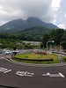
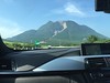
"Tsukumo" means 'nearly 100', and "zuka(tsuka)" means 'mound', now some 40 mounds scarcely remain at the foot of beautiful misty Mt.Yufu-dake(由布岳 1583m alt.) where they call "Tsukahara(塚原=field of mounds)". These mounds were believed to be burial tumuli but they are just rocky mounds without any inner constructions, just like Silbury Hill.
A local legend says that once upon a time, many evil ogres lived here and harmed the residents. The gods felt pity for human beings, then the god of soil egged on the ogres to make 100 mounds within 1 night. When the ogres started to make the 100th mound, the god mimicked a rooster's morning crow. The ogres ran away to deep mountain and left 99 mounds.
You may be viewing yesterday's version of this page. To see the most up to date information please register for a free account.
Do not use the above information on other web sites or publications without permission of the contributor.
Nearby Images from Flickr


The above images may not be of the site on this page, but were taken nearby. They are loaded from Flickr so please click on them for image credits.
Click here to see more info for this site
Nearby sites
Click here to view sites on an interactive map of the areaKey: Red: member's photo, Blue: 3rd party photo, Yellow: other image, Green: no photo - please go there and take one, Grey: site destroyed
Download sites to:
KML (Google Earth)
GPX (GPS waypoints)
CSV (Garmin/Navman)
CSV (Excel)
To unlock full downloads you need to sign up as a Contributory Member. Otherwise downloads are limited to 50 sites.
Turn off the page maps and other distractions
Nearby sites listing. In the following links * = Image available
15.3km NNE 20° Shimoyama* Stone Circle
15.4km N 1° Hakusan Jinja shrine* Stone Circle
15.8km NNW 340° Shimoichi Hyakketsu* Rock Cut Tomb
15.9km NNW 342° Sanmyō Jinja shrine* Standing Stones
16.6km N 355° Sada-no-Kyōishi* Standing Stones
17.1km N 357° Komekami-yama* Stone Circle
17.3km N 354° Koshiki-iwa* Standing Stone (Menhir)
18.1km NE 46° Fujiwara ōishi* Burial Chamber or Dolmen
23.1km ENE 59° Ōhara Family residence garden* Modern Stone Circle etc
23.4km ESE 116° Takio Hyakketsu* Rock Cut Tomb
23.4km W 269° Kurushima Family Residence garden* Modern Stone Circle etc
25.7km NNW 342° Yokkaichi Yokoana* Rock Cut Tomb
26.2km N 4° Kibune Jinja shrine (in Ōita)* Standing Stones
28.2km NNE 12° Anase Yokoana* Rock Cut Tomb
36.8km NW 322° Tōbaru* Hillfort
37.0km NNE 12° Myōkensha shrine* Stone Circle
37.4km S 181° Hekiun-ji temple* Modern Stone Circle etc
37.5km NNE 16° Kisaki-no-Yamanokami* Standing Stone (Menhir)
37.9km S 182° Okyaku Yashiki* Modern Stone Circle etc
39.6km NE 37° JindaiMoji-iwa* Carving
39.7km ESE 117° Usuzuka Kofun* Sculptured Stone
40.2km NNE 22° Kiko Resseki* Stone Circle
40.8km ESE 119° Shimoyama Kofun* Sculptured Stone
44.5km W 270° Jingabaru* Sculptured Stone
50.2km WNW 293° Hikosan temples complex* Modern Stone Circle etc
View more nearby sites and additional images


 We would like to know more about this location. Please feel free to add a brief description and any relevant information in your own language.
 Wir möchten mehr über diese Stätte erfahren. Bitte zögern Sie nicht, eine kurze Beschreibung und relevante Informationen in Deutsch hinzuzufügen.
 Nous aimerions en savoir encore un peu sur les lieux. S'il vous plaît n'hesitez pas à ajouter une courte description et tous les renseignements pertinents dans votre propre langue.
 Quisieramos informarnos un poco más de las lugares. No dude en añadir una breve descripción y otros datos relevantes en su propio idioma.