

<< Our Photo Pages >> Bøstad - Ancient Village or Settlement in Norway in Nordland
Submitted by kenntha88 on Saturday, 13 November 2010 Page Views: 2249
Multi-periodSite Name: Bøstad Alternative Name: BorgelvaCountry: Norway
NOTE: This site is 2.15 km away from the location you searched for.
Fylke: Nordland Type: Ancient Village or Settlement
Nearest Town: Borg Nearest Village: Leknes
Latitude: 68.249922N Longitude: 13.781147E
Condition:
| 5 | Perfect |
| 4 | Almost Perfect |
| 3 | Reasonable but with some damage |
| 2 | Ruined but still recognisable as an ancient site |
| 1 | Pretty much destroyed, possibly visible as crop marks |
| 0 | No data. |
| -1 | Completely destroyed |
| 5 | Superb |
| 4 | Good |
| 3 | Ordinary |
| 2 | Not Good |
| 1 | Awful |
| 0 | No data. |
| 5 | Can be driven to, probably with disabled access |
| 4 | Short walk on a footpath |
| 3 | Requiring a bit more of a walk |
| 2 | A long walk |
| 1 | In the middle of nowhere, a nightmare to find |
| 0 | No data. |
| 5 | co-ordinates taken by GPS or official recorded co-ordinates |
| 4 | co-ordinates scaled from a detailed map |
| 3 | co-ordinates scaled from a bad map |
| 2 | co-ordinates of the nearest village |
| 1 | co-ordinates of the nearest town |
| 0 | no data |
Internal Links:
External Links:
")
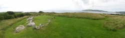
Close to the well-known settlement and the longhouse site of Borg lies another, older settlement from early Iron age. This site is more or less been overlooked by the attention of the Borg museum and the large longhouse, but it is also in my opinion a very interesting site indeed!
The site consists of a circle-shaped settlement with in total of 8 house foundation sites, arranged in two semi-circular rows with four sets of housings on either row surrounding a oval open space between them, very similar with other settlement sites as for example Vollmoen, Lækkenga, Værem or Åse. This is a typical settlement for this time period. Many of these types of settlements have been dated to earlier iron age in the age of wondering.
This settlement has been dated to around 400-500AD.
The house sites can be hard to spot in the terrain, the depressions that marks the house sites does not go deep into the ground. The housings have been from about 5-8 metres in length, and from 3 to 4 metres wide.
The site also consists of two foundation marks from ancient boat houses. These sites are easy to spot and very clear in the terrain because the walls are elevating clearly from the ground, I was able to get some good pictures of the boat houses. One is about 15 metres in length and the other around 6-7 metres in length.
The site has also contained a burial cemetery with a number of round barrows, around 20 in total, but this burial cemetery has sadly been erased completely from construction of a agricultural field close to the site. The mounds have been from about 6 to 11 metres in diameter.
The site has not been made easy to access for visitors, it is no tracks leading to this site, so it can be hard to find, you also have to cross a smaller river to get there from Borg. The entrance area of the Borg museum has been built to resemble this settlement.
You may be viewing yesterday's version of this page. To see the most up to date information please register for a free account.
")
")
")
")
")
")
Do not use the above information on other web sites or publications without permission of the contributor.
Click here to see more info for this site
Nearby sites
Click here to view sites on an interactive map of the areaKey: Red: member's photo, Blue: 3rd party photo, Yellow: other image, Green: no photo - please go there and take one, Grey: site destroyed
Download sites to:
KML (Google Earth)
GPX (GPS waypoints)
CSV (Garmin/Navman)
CSV (Excel)
To unlock full downloads you need to sign up as a Contributory Member. Otherwise downloads are limited to 50 sites.
Turn off the page maps and other distractions
Nearby sites listing. In the following links * = Image available
760m S 179° Borgpollen* Ancient Village or Settlement
1.7km SW 225° Borg longhouse* Ancient Village or Settlement
1.7km SW 230° Lofotr Viking Museum Museum
8.1km NW 323° Utgarden* Ancient Village or Settlement
8.3km NW 321° Eggum Stone Altar* Carving
11.4km SW 215° Skullbru* Barrow Cemetery
12.0km SSW 209° Himmelsteinborga* Hillfort
12.4km ESE 102° Moland* Ancient Village or Settlement
13.1km SSW 209° Fygle* Cairn
13.4km SSW 209° Leknes settlement* Ancient Village or Settlement
13.8km SSW 212° Myrbakk* Ancient Village or Settlement
14.1km ESE 104° Malnes* Standing Stone (Menhir)
15.4km SSW 207° Holsøya Island burial field* Barrow Cemetery
15.8km SSW 200° Ramsvika* Standing Stone (Menhir)
16.2km SSW 196° Kongsrøysa* Cairn
16.2km SW 228° Sversvika* Ancient Village or Settlement
17.0km NE 54° Hov* Stone Row / Alignment
19.6km ESE 105° Rørvika Stone Age Settlement* Ancient Village or Settlement
20.0km ENE 67° Gimsøya monument* Standing Stones
25.9km SW 222° Holsneset boat house* Ancient Village or Settlement
29.0km E 99° Simon Krane cave* Cave or Rock Shelter
29.2km E 97° The troll's rock* Natural Stone / Erratic / Other Natural Feature
29.4km E 98° Konung Hågens Helle* Natural Stone / Erratic / Other Natural Feature
30.2km SW 230° Pun`land* Ancient Village or Settlement
32.5km ENE 60° Klinta* Round Barrow(s)
View more nearby sites and additional images


 We would like to know more about this location. Please feel free to add a brief description and any relevant information in your own language.
 Wir möchten mehr über diese Stätte erfahren. Bitte zögern Sie nicht, eine kurze Beschreibung und relevante Informationen in Deutsch hinzuzufügen.
 Nous aimerions en savoir encore un peu sur les lieux. S'il vous plaît n'hesitez pas à ajouter une courte description et tous les renseignements pertinents dans votre propre langue.
 Quisieramos informarnos un poco más de las lugares. No dude en añadir una breve descripción y otros datos relevantes en su propio idioma.