

<< Our Photo Pages >> Kounov Alignments - Stone Row / Alignment in Czech Republic
Submitted by AlexHunger on Wednesday, 17 May 2006 Page Views: 7902
Neolithic and Bronze AgeSite Name: Kounov Alignments Alternative Name: Kounovské radyCountry: Czech Republic
NOTE: This site is 4.273 km away from the location you searched for.
Type: Stone Row / Alignment
Nearest Town: Praha Nearest Village: Kounov
Latitude: 50.225610N Longitude: 13.695280E
Condition:
| 5 | Perfect |
| 4 | Almost Perfect |
| 3 | Reasonable but with some damage |
| 2 | Ruined but still recognisable as an ancient site |
| 1 | Pretty much destroyed, possibly visible as crop marks |
| 0 | No data. |
| -1 | Completely destroyed |
| 5 | Superb |
| 4 | Good |
| 3 | Ordinary |
| 2 | Not Good |
| 1 | Awful |
| 0 | No data. |
| 5 | Can be driven to, probably with disabled access |
| 4 | Short walk on a footpath |
| 3 | Requiring a bit more of a walk |
| 2 | A long walk |
| 1 | In the middle of nowhere, a nightmare to find |
| 0 | No data. |
| 5 | co-ordinates taken by GPS or official recorded co-ordinates |
| 4 | co-ordinates scaled from a detailed map |
| 3 | co-ordinates scaled from a bad map |
| 2 | co-ordinates of the nearest village |
| 1 | co-ordinates of the nearest town |
| 0 | no data |
Internal Links:
External Links:
")
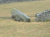
Large alignment in woods and fields with about 14 incomplete exactly parallel rows of up to 350 metres in length with smallish stones.The biggest stone is Gibbon I and weighs about 6000 kg.
Age: reputedly about 700 BCE. Settlement establishment during Neolithic. Today's form is from the late Hallstat age or about 6th Century BCE
ca 1 km from na Rovine hillfort which is maybe a Celtic Sanctuary
Supplementary description from Radek Vinkler
You may be viewing yesterday's version of this page. To see the most up to date information please register for a free account.
")
")
")
")
")
")
")
")
")
")
")
")
")
Do not use the above information on other web sites or publications without permission of the contributor.
Click here to see more info for this site
Nearby sites
Click here to view sites on an interactive map of the areaKey: Red: member's photo, Blue: 3rd party photo, Yellow: other image, Green: no photo - please go there and take one, Grey: site destroyed
Download sites to:
KML (Google Earth)
GPX (GPS waypoints)
CSV (Garmin/Navman)
CSV (Excel)
To unlock full downloads you need to sign up as a Contributory Member. Otherwise downloads are limited to 50 sites.
Turn off the page maps and other distractions
Nearby sites listing. In the following links * = Image available
844m NNW 347° Hradiště Rovina* Hillfort
914m W 269° St. Vojtech Holy Well* Holy Well or Sacred Spring
1.8km WNW 294° Kámen Chodník (Footway stone)* Standing Stone (Menhir)
1.8km WNW 302° Galeje Stone Row* Stone Row / Alignment
1.9km NW 314° Králova řada (The King's row)* Stone Row / Alignment
1.9km NW 311° Stone row east of Slůně* Stone Row / Alignment
1.9km WNW 293° Vizír Stones* Standing Stones
1.9km SW 218° Kounov maze* Modern Stone Circle etc
1.9km WNW 299° Galeje* Standing Stones
2.0km NW 308° Slůně* Standing Stones
2.0km NW 312° Velryba stone* Standing Stone (Menhir)
2.1km WNW 289° Menhir Belgičan (Belgian)* Standing Stone (Menhir)
2.1km NW 305° Stone row Osudová (Faith)* Stone Row / Alignment
2.2km NW 306° Špičák 12 - Stone Pair* Standing Stones
2.2km NW 304° Cásti A Allignment Stone Row / Alignment
2.2km NW 305° Princezna (The Princess)* Standing Stone (Menhir)
2.3km WNW 295° Špičák 15* Stone Row / Alignment
2.3km WNW 294° Špičák 14* Standing Stone (Menhir)
2.4km NW 305° Nebe stones (The Heaven)* Standing Stones
3.2km WNW 284° Něčemice stone alignment II* Stone Row / Alignment
4.7km NW 321° Hradiště Kuk* Hillfort
5.4km NW 305° Něčemice stone alignments* Stone Row / Alignment
8.4km NW 315° Líčkov Menhir* Standing Stone (Menhir)
8.7km NW 308° Kluček alignments* Stone Row / Alignment
8.8km NW 307° Kluček Menhir* Standing Stone (Menhir)
View more nearby sites and additional images


 We would like to know more about this location. Please feel free to add a brief description and any relevant information in your own language.
 Wir möchten mehr über diese Stätte erfahren. Bitte zögern Sie nicht, eine kurze Beschreibung und relevante Informationen in Deutsch hinzuzufügen.
 Nous aimerions en savoir encore un peu sur les lieux. S'il vous plaît n'hesitez pas à ajouter une courte description et tous les renseignements pertinents dans votre propre langue.
 Quisieramos informarnos un poco más de las lugares. No dude en añadir una breve descripción y otros datos relevantes en su propio idioma.