<< Our Photo Pages >> Vätteryd - Stone Circle in Sweden in Skåne
Submitted by Drivved on Sunday, 10 February 2008 Page Views: 4480
Neolithic and Bronze AgeSite Name: Vätteryd Alternative Name: RAÄ Norra Mellby 1:1Country: Sweden Landskap: Skåne Type: Stone Circle
Nearest Town: Hässleholm Nearest Village: Sösdala
Latitude: 56.016940N Longitude: 13.667840E
Condition:
| 5 | Perfect |
| 4 | Almost Perfect |
| 3 | Reasonable but with some damage |
| 2 | Ruined but still recognisable as an ancient site |
| 1 | Pretty much destroyed, possibly visible as crop marks |
| 0 | No data. |
| -1 | Completely destroyed |
| 5 | Superb |
| 4 | Good |
| 3 | Ordinary |
| 2 | Not Good |
| 1 | Awful |
| 0 | No data. |
| 5 | Can be driven to, probably with disabled access |
| 4 | Short walk on a footpath |
| 3 | Requiring a bit more of a walk |
| 2 | A long walk |
| 1 | In the middle of nowhere, a nightmare to find |
| 0 | No data. |
| 5 | co-ordinates taken by GPS or official recorded co-ordinates |
| 4 | co-ordinates scaled from a detailed map |
| 3 | co-ordinates scaled from a bad map |
| 2 | co-ordinates of the nearest village |
| 1 | co-ordinates of the nearest town |
| 0 | no data |
Internal Links:
External Links:
")
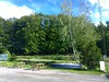
Close to 20 stone ships on a meadow right by the road.
This Iron age burial site is one of the largest in the province of Skåne, with about 375 stones.
You may be viewing yesterday's version of this page. To see the most up to date information please register for a free account.
")
")
")
Do not use the above information on other web sites or publications without permission of the contributor.
Nearby Images from Flickr

The above images may not be of the site on this page, but were taken nearby. They are loaded from Flickr so please click on them for image credits.
Click here to see more info for this site
Nearby sites
Click here to view sites on an interactive map of the areaKey: Red: member's photo, Blue: 3rd party photo, Yellow: other image, Green: no photo - please go there and take one, Grey: site destroyed
Download sites to:
KML (Google Earth)
GPX (GPS waypoints)
CSV (Garmin/Navman)
CSV (Excel)
To unlock full downloads you need to sign up as a Contributory Member. Otherwise downloads are limited to 50 sites.
Turn off the page maps and other distractions
Nearby sites listing. In the following links * = Image available
3.3km SE 130° Hägalinge* Standing Stones
38.5km E 95° Rinkaby Stone Circle* Stone Circle
40.5km S 171° Tyge sten Natural Stone / Erratic / Other Natural Feature
45.1km SSW 201° Södra Ugglarp* Stone Circle
45.7km SW 235° Hög Passage Grave* Passage Grave
46.1km SE 134° Havängsdösen* Burial Chamber or Dolmen
47.4km SE 136° Heimdall Stenar* Stone Circle
50.5km WSW 238° Manhögarna Passage Grave
51.3km SE 136° Kungagraven* Chambered Cairn
51.7km SE 136° Ängakåsen stone circle* Stone Circle
51.8km SE 136° Ängakåsen stone ship* Stone Circle
53.1km W 266° Sliprännor i Gantofta Polissoir
53.2km WSW 238° Gillhög* Passage Grave
54.6km SE 136° Stenshuvud Hillfort
55.1km W 269° Grönehög Round Barrow(s)
55.2km SSE 169° Baldringestenen* Carving
58.7km S 174° Sovestad Runestones* Carving
59.9km NW 317° Lugnarohögen* Round Cairn
61.0km SSE 150° Stenhed* Stone Circle
61.7km S 186° Östra Herrestadstenen* Carving
61.9km S 175° Bjäresjöstenen 1* Carving
62.5km SE 142° Gladsax 2 Passage Grave* Passage Grave
63.2km SSE 164° Stora Köpingestenen* Carving
63.7km SSE 147° Totaskulle* Burial Chamber or Dolmen
63.8km SSE 164° Trollasten Dolmen* Burial Chamber or Dolmen
View more nearby sites and additional images


 We would like to know more about this location. Please feel free to add a brief description and any relevant information in your own language.
 Wir möchten mehr über diese Stätte erfahren. Bitte zögern Sie nicht, eine kurze Beschreibung und relevante Informationen in Deutsch hinzuzufügen.
 Nous aimerions en savoir encore un peu sur les lieux. S'il vous plaît n'hesitez pas à ajouter une courte description et tous les renseignements pertinents dans votre propre langue.
 Quisieramos informarnos un poco más de las lugares. No dude en añadir una breve descripción y otros datos relevantes en su propio idioma.