 with our Megalithic Portal iPhone app")

<< Our Photo Pages >> Dodeok-ri menhir - Standing Stone (Menhir) in South Korea
Submitted by Aska on Saturday, 23 November 2019 Page Views: 513
Neolithic and Bronze AgeSite Name: Dodeok-ri menhir Alternative Name: 도덕리 선돌 道德里立石Country: South Korea
NOTE: This site is 4.106 km away from the location you searched for.
Type: Standing Stone (Menhir)
Nearest Town: Okcheon 옥천 Nearest Village: Annan-myeon Dodeok-ri 안남&#
Latitude: 36.353750N Longitude: 127.677020E
Condition:
| 5 | Perfect |
| 4 | Almost Perfect |
| 3 | Reasonable but with some damage |
| 2 | Ruined but still recognisable as an ancient site |
| 1 | Pretty much destroyed, possibly visible as crop marks |
| 0 | No data. |
| -1 | Completely destroyed |
| 5 | Superb |
| 4 | Good |
| 3 | Ordinary |
| 2 | Not Good |
| 1 | Awful |
| 0 | No data. |
| 5 | Can be driven to, probably with disabled access |
| 4 | Short walk on a footpath |
| 3 | Requiring a bit more of a walk |
| 2 | A long walk |
| 1 | In the middle of nowhere, a nightmare to find |
| 0 | No data. |
| 5 | co-ordinates taken by GPS or official recorded co-ordinates |
| 4 | co-ordinates scaled from a detailed map |
| 3 | co-ordinates scaled from a bad map |
| 2 | co-ordinates of the nearest village |
| 1 | co-ordinates of the nearest town |
| 0 | no data |
Internal Links:
External Links:
")
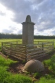
Close to the T-shaped crossroad, there stands a standing stone under a tree. This is one of pair (male-female) stones, another small one is hidden on the other side of the road.
You may be viewing yesterday's version of this page. To see the most up to date information please register for a free account.
Do not use the above information on other web sites or publications without permission of the contributor.
Click here to see more info for this site
Nearby sites
Click here to view sites on an interactive map of the areaKey: Red: member's photo, Blue: 3rd party photo, Yellow: other image, Green: no photo - please go there and take one, Grey: site destroyed
Download sites to:
KML (Google Earth)
GPX (GPS waypoints)
CSV (Garmin/Navman)
CSV (Excel)
To unlock full downloads you need to sign up as a Contributory Member. Otherwise downloads are limited to 50 sites.
Turn off the page maps and other distractions
Nearby sites listing. In the following links * = Image available
1.6km SSW 206° Jongmi-ri menhir* Standing Stone (Menhir)
6.5km SW 232° Seoktan-ni dolmen and menhir* Standing Stone (Menhir)
8.4km SSW 197° Seoktan-ri Menhir* Standing Stone (Menhir)
11.6km SW 231° Chungbuk do* Burial Chamber or Dolmen
16.0km NNE 21° SamnyeonSanseong* Hillfort
20.5km W 274° Birae-dong dolmens* Burial Chamber or Dolmen
36.3km NNW 340° SangdangSanseong* Hillfort
43.3km W 268° 괴정동 Burial Chamber or Dolmen
48.9km WNW 288° 성원리 Burial Chamber or Dolmen
51.0km WNW 284° GongsanSeong* Hillfort
51.8km WNW 284° Songsan-ni gobungun* Rock Art
57.0km W 264° Sangick-ri Dolmen* Burial Chamber or Dolmen
62.4km WSW 250° 성궁리 Burial Chamber or Dolmen
66.2km W 263° Neungsan-ni gobungun* Rock Art
66.5km W 263° BuyeoNasang* Hillfort
66.8km NE 52° Mimyeonsa temple ruin* Pyramid / Mastaba
69.3km WSW 237° Mireuk-sa temple* Ancient Temple
72.0km NW 315° 남송리 Burial Chamber or Dolmen
77.0km ENE 64° Kaesim-sa temple* Ancient Temple
82.6km NNE 13° Buheung-sa temple* Pyramid / Mastaba
82.7km SSE 154° 조포리 Burial Chamber or Dolmen
85.2km E 87° Uiseong Seoktam-ni* Pyramid / Mastaba
86.2km NNE 32° Jecheon Gyo-ri* Pyramid / Mastaba
91.5km NE 36° Gakgi-ri menhirs* Standing Stones
92.0km ENE 65° Andong Seoktam-ni* Pyramid / Mastaba
View more nearby sites and additional images


 We would like to know more about this location. Please feel free to add a brief description and any relevant information in your own language.
 Wir möchten mehr über diese Stätte erfahren. Bitte zögern Sie nicht, eine kurze Beschreibung und relevante Informationen in Deutsch hinzuzufügen.
 Nous aimerions en savoir encore un peu sur les lieux. S'il vous plaît n'hesitez pas à ajouter une courte description et tous les renseignements pertinents dans votre propre langue.
 Quisieramos informarnos un poco más de las lugares. No dude en añadir una breve descripción y otros datos relevantes en su propio idioma.