


<< Our Photo Pages >> Laiji Tsou ceremonial site - Carving in Taiwan
Submitted by KaiHofmann on Sunday, 13 April 2014 Page Views: 7739
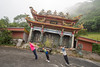
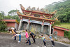
Multi-periodSite Name: Laiji Tsou ceremonial siteCountry: Taiwan
NOTE: This site is 52.903 km away from the location you searched for.
Type: Carving
Nearest Town: Alishan Nearest Village: Laiji
Latitude: 23.532020N Longitude: 120.737914E
Condition:
| 5 | Perfect |
| 4 | Almost Perfect |
| 3 | Reasonable but with some damage |
| 2 | Ruined but still recognisable as an ancient site |
| 1 | Pretty much destroyed, possibly visible as crop marks |
| 0 | No data. |
| -1 | Completely destroyed |
| 5 | Superb |
| 4 | Good |
| 3 | Ordinary |
| 2 | Not Good |
| 1 | Awful |
| 0 | No data. |
| 5 | Can be driven to, probably with disabled access |
| 4 | Short walk on a footpath |
| 3 | Requiring a bit more of a walk |
| 2 | A long walk |
| 1 | In the middle of nowhere, a nightmare to find |
| 0 | No data. |
| 5 | co-ordinates taken by GPS or official recorded co-ordinates |
| 4 | co-ordinates scaled from a detailed map |
| 3 | co-ordinates scaled from a bad map |
| 2 | co-ordinates of the nearest village |
| 1 | co-ordinates of the nearest town |
| 0 | no data |
Internal Links:
External Links:
")
It should prevent landslides and mudflows of the mountains and protect the village. This is probably a very old magic ritual of the tribe.
You may be viewing yesterday's version of this page. To see the most up to date information please register for a free account.
")
")
")
Do not use the above information on other web sites or publications without permission of the contributor.
Nearby Images from Flickr

The above images may not be of the site on this page, but were taken nearby. They are loaded from Flickr so please click on them for image credits.
Click here to see more info for this site
Nearby sites
Click here to view sites on an interactive map of the areaKey: Red: member's photo, Blue: 3rd party photo, Yellow: other image, Green: no photo - please go there and take one, Grey: site destroyed
Download sites to:
KML (Google Earth)
GPX (GPS waypoints)
CSV (Garmin/Navman)
CSV (Excel)
To unlock full downloads you need to sign up as a Contributory Member. Otherwise downloads are limited to 50 sites.
Turn off the page maps and other distractions
Nearby sites listing. In the following links * = Image available
63.7km E 96° Sabat Stone pillars* Standing Stones
76.8km E 101° Baxiandong* Cave or Rock Shelter
80.1km ESE 123° Baishoulian Stone Coffin Rock Cut Tomb
86.7km SE 146° Dulan Stone Wall* Standing Stones
87.2km SE 146° Dulan ruins* Rock Cut Tomb
90.7km SSE 155° Peinan Cultural Park* Ancient Village or Settlement
91.1km SSE 154° Crescent Stone Pillar Taidong* Standing Stones
93.2km SSE 157° Taiwan National Museum of Prehistory* Museum
109.1km SSE 166° The Jiu-Xiang-Lan Site* Cist
148.9km S 175° Weeping Lake Site* Standing Stones
200.1km NNE 24° Yangmingshan Pyramid Pyramid / Mastaba
246.5km ENE 65° Kubura Bari* Natural Stone / Erratic / Other Natural Feature
251.6km ENE 66° Yonaguni Submarine Ruins* Natural Stone / Erratic / Other Natural Feature
252.1km ENE 65° Ichitarai* Holy Well or Sacred Spring
252.8km ENE 65° Ishigantō* Standing Stone (Menhir)
253.1km ENE 65° Urano-bochi necropolis* Chambered Tomb
255.0km ENE 66° DatikuChidi* Broch or Nuraghe
313.0km E 79° Nyū Kōto-muri* Broch or Nuraghe
313.1km ENE 79° Nabikakimasu* Broch or Nuraghe
313.6km ENE 79° Hota-muri* Broch or Nuraghe
314.5km ENE 79° Kōto-muri* Broch or Nuraghe
314.6km ENE 79° Hoshimi-ishi ? (in Hateruma-jima island)* Standing Stone (Menhir)
314.6km E 79° Manjinuya-muri* Broch or Nuraghe
315.0km ENE 78° Shimotabaru-jō* Hillfort
315.4km ENE 79° Mizatu-muri* Broch or Nuraghe
View more nearby sites and additional images


 We would like to know more about this location. Please feel free to add a brief description and any relevant information in your own language.
 Wir möchten mehr über diese Stätte erfahren. Bitte zögern Sie nicht, eine kurze Beschreibung und relevante Informationen in Deutsch hinzuzufügen.
 Nous aimerions en savoir encore un peu sur les lieux. S'il vous plaît n'hesitez pas à ajouter une courte description et tous les renseignements pertinents dans votre propre langue.
 Quisieramos informarnos un poco más de las lugares. No dude en añadir una breve descripción y otros datos relevantes en su propio idioma.