

<< Our Photo Pages >> Nødebo Rundysse - Burial Chamber or Dolmen in Denmark in Hovedstaden
Submitted by kristiansen on Saturday, 02 February 2019 Page Views: 686
Neolithic and Bronze AgeSite Name: Nødebo RundysseCountry: Denmark County: Hovedstaden Type: Burial Chamber or Dolmen
Nearest Town: Hillerød Nearest Village: Nødebo
Latitude: 55.995490N Longitude: 12.329285E
Condition:
| 5 | Perfect |
| 4 | Almost Perfect |
| 3 | Reasonable but with some damage |
| 2 | Ruined but still recognisable as an ancient site |
| 1 | Pretty much destroyed, possibly visible as crop marks |
| 0 | No data. |
| -1 | Completely destroyed |
| 5 | Superb |
| 4 | Good |
| 3 | Ordinary |
| 2 | Not Good |
| 1 | Awful |
| 0 | No data. |
| 5 | Can be driven to, probably with disabled access |
| 4 | Short walk on a footpath |
| 3 | Requiring a bit more of a walk |
| 2 | A long walk |
| 1 | In the middle of nowhere, a nightmare to find |
| 0 | No data. |
| 5 | co-ordinates taken by GPS or official recorded co-ordinates |
| 4 | co-ordinates scaled from a detailed map |
| 3 | co-ordinates scaled from a bad map |
| 2 | co-ordinates of the nearest village |
| 1 | co-ordinates of the nearest town |
| 0 | no data |
Internal Links:
External Links:
")
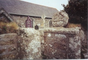
A small dolmen on top of a hill in the forest. There are 12 kerbstones in a circle which is ca. 6 m. in diameter, in the middle the remains of a chamber.
More information at www.kulturarv.dk: Danish Sites and Monuments Record: 010108-73
"Fortidsmindedata Copyright Kulturarvsstyrelsen"
You may be viewing yesterday's version of this page. To see the most up to date information please register for a free account.
")
")
Do not use the above information on other web sites or publications without permission of the contributor.
Nearby Images from Flickr


The above images may not be of the site on this page, but were taken nearby. They are loaded from Flickr so please click on them for image credits.
Click here to see more info for this site
Nearby sites
Click here to view sites on an interactive map of the areaKey: Red: member's photo, Blue: 3rd party photo, Yellow: other image, Green: no photo - please go there and take one, Grey: site destroyed
Download sites to:
KML (Google Earth)
GPX (GPS waypoints)
CSV (Garmin/Navman)
CSV (Excel)
To unlock full downloads you need to sign up as a Contributory Member. Otherwise downloads are limited to 50 sites.
Turn off the page maps and other distractions
Nearby sites listing. In the following links * = Image available
3.0km SW 236° Gribskov Jættestue* Passage Grave
3.1km SW 233° Gribskov Megalitgrav* Burial Chamber or Dolmen
3.6km WNW 282° Kagerup Jættestue* Passage Grave
3.8km SW 221° Gadevang-Huse Langdysse* Long Barrow
4.4km SSE 164° Stenholtsvang Langdysse* Long Barrow
4.6km W 277° Gaarden Jættestue* Passage Grave
4.9km W 276° Gaarden Langdysse* Long Barrow
6.0km WNW 285° Myregård Langdysse* Long Barrow
7.3km ENE 73° Lille Esbønderup Jættestue* Passage Grave
8.0km SSE 151° Slettedalsagre Langhøj* Long Barrow
8.1km WSW 244° Holmgård Jættestue* Passage Grave
8.2km SSE 151° Slettedalsagre Langdysse* Long Barrow
8.4km WSW 250° Neiede Vesterskov Jættestue* Passage Grave
8.5km SW 223° Tjæreby Runddysse* Burial Chamber or Dolmen
8.8km NW 304° Valby Hegn Langdysse 5* Long Barrow
8.8km WNW 303° Valby Hegn Langdysse 6* Long Barrow
8.9km NW 305° Valby Hegn Langdysse 7* Long Barrow
9.0km NW 305° Valby Hegn Langdysse 4* Long Barrow
9.1km W 267° Annisse Jættestue 1* Passage Grave
9.1km NW 306° Valby Hegn Langdysse 3* Long Barrow
9.2km W 265° Annisse Jættestue 2* Passage Grave
9.3km NW 306° Valby Hegn Langdysse 2* Long Barrow
9.3km NW 306° Valby Hegn Langdysse 1* Long Barrow
9.5km SSW 205° Rokkestenen Langdysse* Long Barrow
10.1km NW 308° Kurrebrogård Langdysse* Long Barrow
View more nearby sites and additional images


 We would like to know more about this location. Please feel free to add a brief description and any relevant information in your own language.
 Wir möchten mehr über diese Stätte erfahren. Bitte zögern Sie nicht, eine kurze Beschreibung und relevante Informationen in Deutsch hinzuzufügen.
 Nous aimerions en savoir encore un peu sur les lieux. S'il vous plaît n'hesitez pas à ajouter une courte description et tous les renseignements pertinents dans votre propre langue.
 Quisieramos informarnos un poco más de las lugares. No dude en añadir una breve descripción y otros datos relevantes en su propio idioma.