

<< Our Photo Pages >> Tanum 9:1 Vitlycke - Rock Art in Sweden in Västergötland
Submitted by Tonnox on Thursday, 17 February 2022 Page Views: 718
Rock ArtSite Name: Tanum 9:1 VitlyckeCountry: Sweden Landskap: Västergötland Type: Rock Art
Nearest Town: Tanumshede Nearest Village: Gerum
Latitude: 58.699935N Longitude: 11.335935E
Condition:
| 5 | Perfect |
| 4 | Almost Perfect |
| 3 | Reasonable but with some damage |
| 2 | Ruined but still recognisable as an ancient site |
| 1 | Pretty much destroyed, possibly visible as crop marks |
| 0 | No data. |
| -1 | Completely destroyed |
| 5 | Superb |
| 4 | Good |
| 3 | Ordinary |
| 2 | Not Good |
| 1 | Awful |
| 0 | No data. |
| 5 | Can be driven to, probably with disabled access |
| 4 | Short walk on a footpath |
| 3 | Requiring a bit more of a walk |
| 2 | A long walk |
| 1 | In the middle of nowhere, a nightmare to find |
| 0 | No data. |
| 5 | co-ordinates taken by GPS or official recorded co-ordinates |
| 4 | co-ordinates scaled from a detailed map |
| 3 | co-ordinates scaled from a bad map |
| 2 | co-ordinates of the nearest village |
| 1 | co-ordinates of the nearest town |
| 0 | no data |
Internal Links:
External Links:
I have visited· I would like to visit
CharcoalBurner89 visited on 21st Aug 2023 - their rating: Cond: 4 Amb: 5 Access: 3 Follow the signs up the hill and you will see more rock carvings. The information boards will definitely be maintained!
Tonnox visited on 9th Sep 2019 - their rating: Cond: 5 Amb: 5 Access: 2
Average ratings for this site from all visit loggers: Condition: 4.5 Ambience: 5 Access: 2.5
")
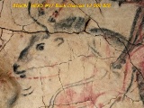
Tanum 9:1 Vitlycke. Rock Art.
More information:
Fornsök, Riksantikvarieämbetet, Sweden
Tanum 9:1 Vitlycke Rock Art
More informtion:
Kringla, Riksantikvarieämbetet, Sweden
Tanum 9:1 Vitlycke Rock Art
You may be viewing yesterday's version of this page. To see the most up to date information please register for a free account.
")
")
")
")
")
")
")
")
")
")
")
")
")
")
")
Do not use the above information on other web sites or publications without permission of the contributor.
Click here to see more info for this site
Nearby sites
Click here to view sites on an interactive map of the areaKey: Red: member's photo, Blue: 3rd party photo, Yellow: other image, Green: no photo - please go there and take one, Grey: site destroyed
Download sites to:
KML (Google Earth)
GPX (GPS waypoints)
CSV (Garmin/Navman)
CSV (Excel)
To unlock full downloads you need to sign up as a Contributory Member. Otherwise downloads are limited to 50 sites.
Turn off the page maps and other distractions
Nearby sites listing. In the following links * = Image available
78m SE 138° Tanum 6:1 Vitlycke* Rock Art
204m NNE 16° Tanums Hällristningar* Carving
204m NNE 16° Vitlycke Carvings* Rock Art
324m NNW 332° Vitlycke Rösen* Round Cairn
344m NE 43° Vitlycke Museum* Museum
405m NE 42° Vitlycke gravfelt* Barrow Cemetery
549m SSE 160° Aspeberget* Carving
720m SSE 158° Tanum 18:1 Aspeberget* Rock Art
759m SSE 163° Aspeberget RAÄ nr 26:1* Rock Art
779m SSE 164° Tanum 28:1 Aspeberget* Rock Art
794m SSE 162° Tanum 25:1 Aspeberget* Rock Art
1.3km SSW 203° Tanum 72:1 Tegneby* Rock Art
1.4km SSW 207° Litsleby* Carving
1.8km WNW 291° Björnemyren Hällkista* Cist
1.8km N 355° Kallebystenen* Carving
2.0km SE 135° Gerum Rune Rock* Rock Art
2.2km S 186° Tanum 192:1 Bro Utmark* Rock Art
2.2km SSE 152° Lövåsen Hällristningar* Rock Art
2.4km SSW 195° Emelieborg* Rock Art
3.0km NW 320° Säm Gånggrift* Passage Grave
3.1km NW 326° Tanumshede Gravröse (1)* Cairn
3.3km SE 135° Tanum 357:1 Sotetorp* Rock Art
3.9km NE 45° Fossum (Tanum)* Carving
4.0km NE 45° Balken* Rock Art
4.4km W 271° Greby* Barrow Cemetery
View more nearby sites and additional images


 We would like to know more about this location. Please feel free to add a brief description and any relevant information in your own language.
 Wir möchten mehr über diese Stätte erfahren. Bitte zögern Sie nicht, eine kurze Beschreibung und relevante Informationen in Deutsch hinzuzufügen.
 Nous aimerions en savoir encore un peu sur les lieux. S'il vous plaît n'hesitez pas à ajouter une courte description et tous les renseignements pertinents dans votre propre langue.
 Quisieramos informarnos un poco más de las lugares. No dude en añadir una breve descripción y otros datos relevantes en su propio idioma.