
, Aubrey Burl")
<< Our Photo Pages >> Bøkeskogen - Barrow Cemetery in Norway in Vestfold
Submitted by kenntha88 on Sunday, 24 August 2014 Page Views: 1294
Neolithic and Bronze AgeSite Name: BøkeskogenCountry: Norway
NOTE: This site is 1.854 km away from the location you searched for.
Fylke: Vestfold Type: Barrow Cemetery
Nearest Town: Larvik
Latitude: 59.057858N Longitude: 10.023909E
Condition:
| 5 | Perfect |
| 4 | Almost Perfect |
| 3 | Reasonable but with some damage |
| 2 | Ruined but still recognisable as an ancient site |
| 1 | Pretty much destroyed, possibly visible as crop marks |
| 0 | No data. |
| -1 | Completely destroyed |
| 5 | Superb |
| 4 | Good |
| 3 | Ordinary |
| 2 | Not Good |
| 1 | Awful |
| 0 | No data. |
| 5 | Can be driven to, probably with disabled access |
| 4 | Short walk on a footpath |
| 3 | Requiring a bit more of a walk |
| 2 | A long walk |
| 1 | In the middle of nowhere, a nightmare to find |
| 0 | No data. |
| 5 | co-ordinates taken by GPS or official recorded co-ordinates |
| 4 | co-ordinates scaled from a detailed map |
| 3 | co-ordinates scaled from a bad map |
| 2 | co-ordinates of the nearest village |
| 1 | co-ordinates of the nearest town |
| 0 | no data |
Internal Links:
External Links:
")
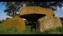
The Bøkeskogen forest in the middle of the town Larvik is Norway's only natural beech forest. It is a protected forest and it has been made a public park. It was among the first public parks in Norway. It is a stone fence surrounding the park and several footpaths and picnic tables and information signs are located in the forest.
In this forest there are two large barrow cemeteries from early to later iron age. They are known as the upper and lower barrow cemeteries. The lower cemetery consists of 36 barrows. This barrow cemetery is difficult to observe and photograph because it is heavily overgrown with smaller trees and brush.
The upper barrow cemetery on the ridge that is the highest area in the forest have been cleaned for small brush. There is only a deep layer of dead leaves on the forest floor under the tall beech trees. It consists of around 23 round and 3 elongated barrows. The largest round barrow is around 25 metres in diameter and around 2 metres in height. The other barrows vary from around 15 to 6 metres in diameter and from 0.5 to 1.5 metres in height. They are easy to see and find and some also have ditches around the edges.
Most of the barrows have been disturbed and some have deep craters on top and some have been flattened in later years. Some of the barrows however, have been reconstructed recently. The barrows have been dated to later iron age, around 800-900AD. but some of the mounds could go back further in time.
Only some findings are known from the cemetery. They are from 5 barrows, four male burials and one female. In one of the barrows was found a small boat.
The whole park is a beautiful area and is well worth a visit!
You may be viewing yesterday's version of this page. To see the most up to date information please register for a free account.
")
")
")
")
")
")
")
")
")
")
")
")
")
")
")
")
")
")
")
")
Do not use the above information on other web sites or publications without permission of the contributor.
Click here to see more info for this site
Nearby sites
Click here to view sites on an interactive map of the areaKey: Red: member's photo, Blue: 3rd party photo, Yellow: other image, Green: no photo - please go there and take one, Grey: site destroyed
Download sites to:
KML (Google Earth)
GPX (GPS waypoints)
CSV (Garmin/Navman)
CSV (Excel)
To unlock full downloads you need to sign up as a Contributory Member. Otherwise downloads are limited to 50 sites.
Turn off the page maps and other distractions
Nearby sites listing. In the following links * = Image available
3.5km ENE 69° Rauanveien* Standing Stone (Menhir)
4.1km ESE 102° Valbysteinene Stone Setting* Stone Circle
4.1km ENE 73° Kjøndal Pagan Altar* Sculptured Stone
4.9km S 173° Agnes stones* Stone Circle
4.9km SW 220° Presteåsen* Standing Stone (Menhir)
5.0km E 96° Tjøllingveien-Kongehaugen* Round Barrow(s)
5.2km ESE 119° Toa cemetery* Barrow Cemetery
5.3km ESE 124° Skiringssal Kaupang* Ancient Village or Settlement
5.4km S 172° Agnesodden Stone Setting* Stone Circle
5.5km S 183° Brunla cemetery* Barrow Cemetery
5.5km NNE 24° Skauen* Barrow Cemetery
5.6km ESE 121° Lamøya barrow cemetery* Barrow Cemetery
5.9km SW 221° Bratthaugåsen* Barrow Cemetery
6.0km SW 222° Hvatum Standing Stone* Standing Stone (Menhir)
6.5km NNE 20° Søndre Lunde* Barrow Cemetery
6.6km SW 231° Kongerødhaugen Barrow* Round Barrow(s)
7.3km E 90° Varil Vestre* Stone Circle
7.5km NNE 15° Hedrum Cemetery* Barrow Cemetery
7.8km E 85° Sandtra stone circle* Stone Circle
7.9km SW 227° Sannisteinen* Standing Stone (Menhir)
9.0km E 86° Hosle standing stone* Standing Stone (Menhir)
9.6km ENE 63° Istrehågan - Skipssetningen* Stone Circle
10.0km E 88° Øvre Kleppaker* Stone Circle
10.0km ENE 57° Furustadlia* Standing Stone (Menhir)
10.1km ENE 60° Jåbergskogen* Stone Row / Alignment
View more nearby sites and additional images


 We would like to know more about this location. Please feel free to add a brief description and any relevant information in your own language.
 Wir möchten mehr über diese Stätte erfahren. Bitte zögern Sie nicht, eine kurze Beschreibung und relevante Informationen in Deutsch hinzuzufügen.
 Nous aimerions en savoir encore un peu sur les lieux. S'il vous plaît n'hesitez pas à ajouter une courte description et tous les renseignements pertinents dans votre propre langue.
 Quisieramos informarnos un poco más de las lugares. No dude en añadir una breve descripción y otros datos relevantes en su propio idioma.