<< Our Photo Pages >> Ladywell (Blythborough) - Holy Well or Sacred Spring in England in Suffolk
Submitted by HOLYWELL on Tuesday, 29 August 2006 Page Views: 9111
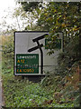
Springs and Holy WellsSite Name: Ladywell (Blythborough) Alternative Name: Wishing Well (Blythborough); Queen Anne's Well; Lady's FountainCountry: England
NOTE: This site is 3.8 km away from the location you searched for.
County: Suffolk Type: Holy Well or Sacred Spring
Nearest Village: Blythborough
Map Ref: TM450762
Latitude: 52.329145N Longitude: 1.594293E
Condition:
| 5 | Perfect |
| 4 | Almost Perfect |
| 3 | Reasonable but with some damage |
| 2 | Ruined but still recognisable as an ancient site |
| 1 | Pretty much destroyed, possibly visible as crop marks |
| 0 | No data. |
| -1 | Completely destroyed |
| 5 | Superb |
| 4 | Good |
| 3 | Ordinary |
| 2 | Not Good |
| 1 | Awful |
| 0 | No data. |
| 5 | Can be driven to, probably with disabled access |
| 4 | Short walk on a footpath |
| 3 | Requiring a bit more of a walk |
| 2 | A long walk |
| 1 | In the middle of nowhere, a nightmare to find |
| 0 | No data. |
| 5 | co-ordinates taken by GPS or official recorded co-ordinates |
| 4 | co-ordinates scaled from a detailed map |
| 3 | co-ordinates scaled from a bad map |
| 2 | co-ordinates of the nearest village |
| 1 | co-ordinates of the nearest town |
| 0 | no data |
Internal Links:
External Links:
I have visited· I would like to visit
hales would like to visit
 (PID:23683)")
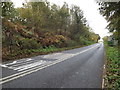
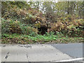
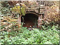
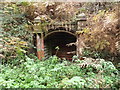
Now beside a busy lane, spring lane at the south end of Henham Park not far from Blythborough church. The present now dried up fountain head of brick and stone arch was erected by the first Countess of Stradbrooke. It was probably dedicated to our lady and once had a cup attached to drink the water. In 1833 the ‘Lady’s Fountain’ poem by Agnes Strickland was written about the well.
The Northern Antiquarian (TNA) also features a page for this well - see their entry for Lady’s Well, Blythborough, Suffolk, which gives directions for finding this well together with a photograph, a brief archaeology & history and local folklore.
TNA add "The spring is said to be near the reputed to be the place of King Onna’s death (654 AD) ... A large structure is a brick and stone arch and which has two low seats inside, giving the alternative name of Tramp’s or Traveller’s Rest having also brass cups attached to the structure for anyone wishing to drink there. The age of the fabric has said to be mainly 1780, although one view was that it was erected by the first Countess of Stradbrooke in the 19th century and may be that recorded in 1833 in the poem ‘Lady’s Fountain’ poem by Agnes Strickland (the alternative name Lady coming from the Lady Strickland). Another view is that some of the fabric is 13th century in origin. The structure is now dry and overgrown, apparently last having water in the 1900s."
You may be viewing yesterday's version of this page. To see the most up to date information please register for a free account.
Do not use the above information on other web sites or publications without permission of the contributor.
Nearby Images from Geograph Britain and Ireland:
©2013(licence)
©2013(licence)
©2013(licence)
©2013(licence)
©2013(licence)
The above images may not be of the site on this page, they are loaded from Geograph.
Please Submit an Image of this site or go out and take one for us!
Click here to see more info for this site
Nearby sites
Key: Red: member's photo, Blue: 3rd party photo, Yellow: other image, Green: no photo - please go there and take one, Grey: site destroyed
Download sites to:
KML (Google Earth)
GPX (GPS waypoints)
CSV (Garmin/Navman)
CSV (Excel)
To unlock full downloads you need to sign up as a Contributory Member. Otherwise downloads are limited to 50 sites.
Turn off the page maps and other distractions
Nearby sites listing. In the following links * = Image available
2.6km SE 125° Walberswick Burial Mounds* Round Barrow(s) (TM4718274820)
17.6km NW 323° Druid's Stone (Bungay)* Natural Stone / Erratic / Other Natural Feature (TM3366689739)
17.8km NW 307° Flixton Park Quarry Timber Circle (TM303863)
18.4km NNW 328° Broome Heath Long Barrow Long Barrow (TM344913)
19.5km NNW 344° Stockton Stone* Standing Stone (Menhir) (TM386946)
19.9km SSW 194° Iken Saxon Cross* Ancient Cross (TM412566)
20.7km NNE 32° The Witches' Stones, Lowestoft Modern Stone Circle etc (TM5505294359)
23.0km W 269° Kesgrave Bowl Barrow 2 Round Barrow(s) (TM220745)
25.0km N 10° Bell Hill Round Barrow(s) (TG480010)
25.0km N 10° Mill Hill Round Barrow(s) (TG480010)
26.9km W 275° St. Edmund's Cross Ancient Cross (TM1877)
28.2km NNE 18° Gull Stones (Great Yarmouth) Sculptured Stone (TG524035)
28.3km N 8° Burgh Castle Shore Fort Stone Fort or Dun (TG474044)
31.7km NW 311° Tasburgh Fort* Hillfort (TM201960)
31.9km SSW 213° Sutton Hoo* Artificial Mound (TM288487)
32.8km SW 226° Burgh Enclosure Ancient Village or Settlement (TM224523)
33.4km W 279° Diss Museum* Museum (TM1171179980)
33.7km SSW 205° Shottisham Monument Complex Henge (TM32004505)
34.9km NW 324° Venta Icenorum* Ancient Village or Settlement (TG230034)
36.1km WSW 256° Mendlesham Preaching Stone* Natural Stone / Erratic / Other Natural Feature (TM103658)
36.2km SW 219° Martlesham Heath* Round Barrow(s) (TM238468)
36.4km NNW 328° Arminghall Henge* Henge (TG240060)
36.4km SW 215° Falcon Park Round Barrow(s) (TM25504534)
36.5km SW 217° Martlesham Airfield Round Barrow(s) (TM24224616)
36.8km SW 218° Martlesham Bowl Barrow 2* Round Barrow(s) (TM23874598)
View more nearby sites and additional images


 We would like to know more about this location. Please feel free to add a brief description and any relevant information in your own language.
 Wir möchten mehr über diese Stätte erfahren. Bitte zögern Sie nicht, eine kurze Beschreibung und relevante Informationen in Deutsch hinzuzufügen.
 Nous aimerions en savoir encore un peu sur les lieux. S'il vous plaît n'hesitez pas à ajouter une courte description et tous les renseignements pertinents dans votre propre langue.
 Quisieramos informarnos un poco más de las lugares. No dude en añadir una breve descripción y otros datos relevantes en su propio idioma.