<< Our Photo Pages >> Mendlesham Preaching Stone - Natural Stone / Erratic / Other Natural Feature in England in Suffolk
Submitted by willowman1 on Wednesday, 28 September 2016 Page Views: 3730
Natural PlacesSite Name: Mendlesham Preaching StoneCountry: England County: Suffolk Type: Natural Stone / Erratic / Other Natural Feature
Nearest Town: Mendlesham
Map Ref: TM103658
Latitude: 52.250169N Longitude: 1.079402E
Condition:
| 5 | Perfect |
| 4 | Almost Perfect |
| 3 | Reasonable but with some damage |
| 2 | Ruined but still recognisable as an ancient site |
| 1 | Pretty much destroyed, possibly visible as crop marks |
| 0 | No data. |
| -1 | Completely destroyed |
| 5 | Superb |
| 4 | Good |
| 3 | Ordinary |
| 2 | Not Good |
| 1 | Awful |
| 0 | No data. |
| 5 | Can be driven to, probably with disabled access |
| 4 | Short walk on a footpath |
| 3 | Requiring a bit more of a walk |
| 2 | A long walk |
| 1 | In the middle of nowhere, a nightmare to find |
| 0 | No data. |
| 5 | co-ordinates taken by GPS or official recorded co-ordinates |
| 4 | co-ordinates scaled from a detailed map |
| 3 | co-ordinates scaled from a bad map |
| 2 | co-ordinates of the nearest village |
| 1 | co-ordinates of the nearest town |
| 0 | no data |
Internal Links:
External Links:
I have visited· I would like to visit
DaygloViking has visited here
")
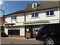
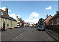
The Preaching Stone is a glacial erratic in Old Market Street, Mendlesham. It was supposedly used in the 15th century by wandering friars as a gathering point for their open air preaching, and by John Wesley 300 years later.
You may be viewing yesterday's version of this page. To see the most up to date information please register for a free account.
Do not use the above information on other web sites or publications without permission of the contributor.
Nearby Images from Geograph Britain and Ireland:
©2015(licence)

©2015(licence)
©2015(licence)

©2015(licence)
©2015(licence)
The above images may not be of the site on this page, they are loaded from Geograph.
Please Submit an Image of this site or go out and take one for us!
Click here to see more info for this site
Nearby sites
Key: Red: member's photo, Blue: 3rd party photo, Yellow: other image, Green: no photo - please go there and take one, Grey: site destroyed
Download sites to:
KML (Google Earth)
GPX (GPS waypoints)
CSV (Garmin/Navman)
CSV (Excel)
To unlock full downloads you need to sign up as a Contributory Member. Otherwise downloads are limited to 50 sites.
Turn off the page maps and other distractions
Nearby sites listing. In the following links * = Image available
11.4km SSW 204° Lady Well, Badley Holy Well or Sacred Spring (TM06135517)
13.0km WSW 259° Lady Well, Woolpit* Holy Well or Sacred Spring (TL9763362676)
13.3km WSW 258° Woolpit Cross* Ancient Cross (TL974625)
13.3km WNW 299° Artificial Mound near Wrenshall Farm Artificial Mound (TL9836071843)
13.6km NE 37° St. Edmund's Cross Ancient Cross (TM1877)
14.2km N 8° Diss Museum* Museum (TM1171179980)
14.5km NE 56° Kesgrave Bowl Barrow 2 Round Barrow(s) (TM220745)
14.8km NNW 328° St. Mary's Well (Thelnetham)* Holy Well or Sacred Spring (TM0201578071)
16.0km NNW 344° South Lopham Ox-Foot Stone* Natural Stone / Erratic / Other Natural Feature (TM05178098)
16.5km WNW 283° Pakenham Cursus Cursus (TL940688)
17.2km SW 223° Cross Green Puddingstone Natural Stone / Erratic / Other Natural Feature (TL990528)
17.8km SW 217° Wattisham Stone* Natural Stone / Erratic / Other Natural Feature (TM0027151103)
18.1km SE 141° Burgh Enclosure Ancient Village or Settlement (TM224523)
19.5km NNW 328° Home Covert Tumulus* Round Barrow(s) (TL99138177)
19.6km NNW 327° Devil's Ditch* Misc. Earthwork (TL9879281705)
19.8km NNW 326° Riddlesworth Tumulus Round Barrow(s) (TL98648180)
19.8km SW 216° Bildeston Puddingstone Natural Stone / Erratic / Other Natural Feature (TL992494)
20.7km NW 317° Knettishall bowl barrow* Round Barrow(s) (TL9546280239)
20.9km NNW 330° Soldier's Hill Round Barrow(s) (TL99008346)
21.4km W 275° St. John's Well (Suffolk)* Holy Well or Sacred Spring (TL889669)
21.5km NNW 332° East Harling Heath Tumulus* Round Barrow(s) (TL99238425)
22.0km SW 214° Chelsworth Puddingstone Natural Stone / Erratic / Other Natural Feature (TL987471)
22.2km WNW 294° Troston Mount* Round Barrow(s) (TL896741)
22.4km WNW 297° Honington Barrows Round Barrow(s) (TL899751)
22.4km NNW 331° West Harling Tumulus Round Barrow(s) (TL98438486)
View more nearby sites and additional images


 We would like to know more about this location. Please feel free to add a brief description and any relevant information in your own language.
 Wir möchten mehr über diese Stätte erfahren. Bitte zögern Sie nicht, eine kurze Beschreibung und relevante Informationen in Deutsch hinzuzufügen.
 Nous aimerions en savoir encore un peu sur les lieux. S'il vous plaît n'hesitez pas à ajouter une courte description et tous les renseignements pertinents dans votre propre langue.
 Quisieramos informarnos un poco más de las lugares. No dude en añadir una breve descripción y otros datos relevantes en su propio idioma.