 with our Megalithic Portal iPhone app")

<< Our Photo Pages >> St Withburga's Well - Holy Well or Sacred Spring in England in Norfolk
Submitted by vicky on Tuesday, 31 August 2004 Page Views: 19782
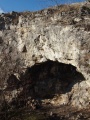
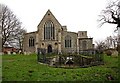
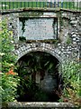
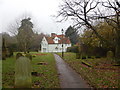
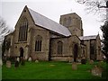
Springs and Holy WellsSite Name: St Withburga's WellCountry: England
NOTE: This site is 1.416 km away from the location you searched for.
County: Norfolk Type: Holy Well or Sacred Spring
Nearest Village: East Dereham
Map Ref: TF9865213305 Landranger Map Number: 132
Latitude: 52.681007N Longitude: 0.937285E
Condition:
| 5 | Perfect |
| 4 | Almost Perfect |
| 3 | Reasonable but with some damage |
| 2 | Ruined but still recognisable as an ancient site |
| 1 | Pretty much destroyed, possibly visible as crop marks |
| 0 | No data. |
| -1 | Completely destroyed |
| 5 | Superb |
| 4 | Good |
| 3 | Ordinary |
| 2 | Not Good |
| 1 | Awful |
| 0 | No data. |
| 5 | Can be driven to, probably with disabled access |
| 4 | Short walk on a footpath |
| 3 | Requiring a bit more of a walk |
| 2 | A long walk |
| 1 | In the middle of nowhere, a nightmare to find |
| 0 | No data. |
| 5 | co-ordinates taken by GPS or official recorded co-ordinates |
| 4 | co-ordinates scaled from a detailed map |
| 3 | co-ordinates scaled from a bad map |
| 2 | co-ordinates of the nearest village |
| 1 | co-ordinates of the nearest town |
| 0 | no data |
Internal Links:
External Links:
I have visited· I would like to visit
RedKite1985 visited on 10th May 2023 - their rating: Cond: 3 Amb: 3 Access: 5
")
A plaque records that "The ruins of a tomb which contained the remains of Withburga, youngest daughter of Anna, King of East Angles, who died AD 654. The Abbot and monks of Ely stole this precious relic and translocated to Ely Cathedral, where it was interred near her three royal sisters, AD 974"
You may be viewing yesterday's version of this page. To see the most up to date information please register for a free account.
")
")
")
")
Do not use the above information on other web sites or publications without permission of the contributor.
Nearby Images from Geograph Britain and Ireland:
©2008(licence)

©2015(licence)
©2005(licence)
©2016(licence)
©2007(licence)
The above images may not be of the site on this page, they are loaded from Geograph.
Please Submit an Image of this site or go out and take one for us!
Click here to see more info for this site
Nearby sites
Key: Red: member's photo, Blue: 3rd party photo, Yellow: other image, Green: no photo - please go there and take one, Grey: site destroyed
Download sites to:
KML (Google Earth)
GPX (GPS waypoints)
CSV (Garmin/Navman)
CSV (Excel)
To unlock full downloads you need to sign up as a Contributory Member. Otherwise downloads are limited to 50 sites.
Turn off the page maps and other distractions
Nearby sites listing. In the following links * = Image available
4.6km NW 306° St Agnes Well, Longham* Holy Well or Sacred Spring (TF94831586)
8.3km N 4° North Elmham Chapel* Ancient Temple (TF9888121640)
12.1km NNW 329° Whissonsett wheel-head cross* Ancient Cross (TF91922334)
12.3km SW 231° Devil's Dyke (Norfolk)* Misc. Earthwork (TF8934705200)
13.5km ENE 72° The Warren Barrow Round Barrow(s) (TG11371798)
13.9km NE 48° Pettywell* Holy Well or Sacred Spring (TG086230)
14.1km WNW 302° Litcham Heath* Round Barrow(s) (TF863202)
14.8km WNW 298° Weasenham Plantation* Barrow Cemetery (TF853198)
14.9km ENE 73° Alderford Common Barrow Round Barrow(s) (TG12751828)
16.8km SE 137° St Thomas's Well (Wymondham)* Holy Well or Sacred Spring (TG10550146)
16.9km SW 215° Merton Stone* Natural Stone / Erratic / Other Natural Feature (TL895991)
17.2km ESE 108° St Walstan's Well* Holy Well or Sacred Spring (TG15350878)
18.3km ESE 101° Roundwell* Holy Well or Sacred Spring (TG168104)
19.3km SW 223° Little Cressingham Barrow Cemetery* Barrow Cemetery (TL861986)
20.4km E 80° Horsford Woods Barrow Cemetary* Barrow Cemetery (TG18571780)
20.5km WSW 246° Cockley Cley Iceni Village* Museum (TF802043)
20.6km NW 307° West Rudham* Round Barrow(s) (TF81652495)
21.1km WSW 247° St Mary’s Chapel, Cockley Cley* Ancient Temple (TF79550411)
21.3km NW 307° West Rudham Cursus Cursus (TF810254)
21.9km NW 309° West Rudham South* Long Barrow (TF810263)
21.9km NW 309° West Rudham North* Long Barrow (TF810264)
22.2km ENE 62° Maiden's Head* Holy Well or Sacred Spring (TG178246)
22.8km NW 322° Wicken Covert Barrow Round Barrow(s) (TF83973081)
23.0km NW 321° Coxford Heath Barrow Round Barrow(s) (TF83493070)
23.3km S 176° Gallows Hill Tumulus Round Barrow(s) (TM01419019)
View more nearby sites and additional images


 We would like to know more about this location. Please feel free to add a brief description and any relevant information in your own language.
 Wir möchten mehr über diese Stätte erfahren. Bitte zögern Sie nicht, eine kurze Beschreibung und relevante Informationen in Deutsch hinzuzufügen.
 Nous aimerions en savoir encore un peu sur les lieux. S'il vous plaît n'hesitez pas à ajouter une courte description et tous les renseignements pertinents dans votre propre langue.
 Quisieramos informarnos un poco más de las lugares. No dude en añadir una breve descripción y otros datos relevantes en su propio idioma.