<< Our Photo Pages >> North Elmham Chapel - Ancient Temple in England in Norfolk
Submitted by Antonine on Monday, 04 July 2022 Page Views: 505
Medieval (High and Late)Site Name: North Elmham Chapel Alternative Name: North Elmham Saxon CathedralCountry: England
NOTE: This site is 8.261 km away from the location you searched for.
County: Norfolk Type: Ancient Temple
Nearest Town: North Elmham
Map Ref: TF9888121640
Latitude: 52.755752N Longitude: 0.945708E
Condition:
| 5 | Perfect |
| 4 | Almost Perfect |
| 3 | Reasonable but with some damage |
| 2 | Ruined but still recognisable as an ancient site |
| 1 | Pretty much destroyed, possibly visible as crop marks |
| 0 | No data. |
| -1 | Completely destroyed |
| 5 | Superb |
| 4 | Good |
| 3 | Ordinary |
| 2 | Not Good |
| 1 | Awful |
| 0 | No data. |
| 5 | Can be driven to, probably with disabled access |
| 4 | Short walk on a footpath |
| 3 | Requiring a bit more of a walk |
| 2 | A long walk |
| 1 | In the middle of nowhere, a nightmare to find |
| 0 | No data. |
| 5 | co-ordinates taken by GPS or official recorded co-ordinates |
| 4 | co-ordinates scaled from a detailed map |
| 3 | co-ordinates scaled from a bad map |
| 2 | co-ordinates of the nearest village |
| 1 | co-ordinates of the nearest town |
| 0 | no data |
Internal Links:
External Links:
")
[Note: this site is scheduled as Historic England List ID 1017911, 'Episcopal chapel and fortified manor house on site of Anglo-Saxon cathedral'.]
You may be viewing yesterday's version of this page. To see the most up to date information please register for a free account.
")
")
")
")
Do not use the above information on other web sites or publications without permission of the contributor.
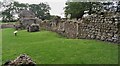
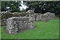
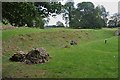
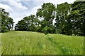
Nearby Images from Geograph Britain and Ireland:
©2010(licence)
©2010(licence)
©2010(licence)

©2007(licence)
©2019(licence)
The above images may not be of the site on this page, they are loaded from Geograph.
Please Submit an Image of this site or go out and take one for us!
Click here to see more info for this site
Nearby sites
Key: Red: member's photo, Blue: 3rd party photo, Yellow: other image, Green: no photo - please go there and take one, Grey: site destroyed
Download sites to:
KML (Google Earth)
GPX (GPS waypoints)
CSV (Garmin/Navman)
CSV (Excel)
To unlock full downloads you need to sign up as a Contributory Member. Otherwise downloads are limited to 50 sites.
Turn off the page maps and other distractions
Nearby sites listing. In the following links * = Image available
7.0km SW 217° St Agnes Well, Longham* Holy Well or Sacred Spring (TF94831586)
7.1km WNW 286° Whissonsett wheel-head cross* Ancient Cross (TF91922334)
8.3km S 184° St Withburga's Well* Holy Well or Sacred Spring (TF9865213305)
9.8km E 84° Pettywell* Holy Well or Sacred Spring (TG086230)
12.6km W 266° Litcham Heath* Round Barrow(s) (TF863202)
13.0km ESE 109° The Warren Barrow Round Barrow(s) (TG11371798)
13.7km W 265° Weasenham Plantation* Barrow Cemetery (TF853198)
14.2km ESE 106° Alderford Common Barrow Round Barrow(s) (TG12751828)
16.0km NNW 343° Little Walsingham Holy Well* Holy Well or Sacred Spring (TF93603678)
16.1km NNW 343° Our Lady of Walsingham Holy Well* Holy Well or Sacred Spring (TF9355136894)
17.5km NW 304° Wicken Covert Barrow Round Barrow(s) (TF83973081)
17.5km WNW 283° West Rudham* Round Barrow(s) (TF81652495)
17.8km WNW 303° Coxford Heath Barrow Round Barrow(s) (TF83493070)
18.2km WNW 284° West Rudham Cursus Cursus (TF810254)
18.4km WNW 287° West Rudham South* Long Barrow (TF810263)
18.4km WNW 287° West Rudham North* Long Barrow (TF810264)
19.0km SSW 212° Devil's Dyke (Norfolk)* Misc. Earthwork (TF8934705200)
19.1km E 83° Maiden's Head* Holy Well or Sacred Spring (TG178246)
19.5km NW 316° South Creake* Hillfort (TF848352)
19.6km N 354° Fiddler's Hill (Norfolk)* Round Barrow(s) (TF96134105)
19.8km N 349° Warham Camp* Hillfort (TF94374089)
20.0km ESE 103° Horsford Woods Barrow Cemetary* Barrow Cemetery (TG18571780)
20.8km SE 130° St Walstan's Well* Holy Well or Sacred Spring (TG15350878)
21.1km SE 125° Roundwell* Holy Well or Sacred Spring (TG168104)
22.2km N 10° Blakeney Downs Barrows Round Barrow(s) (TG01864365)
View more nearby sites and additional images


 We would like to know more about this location. Please feel free to add a brief description and any relevant information in your own language.
 Wir möchten mehr über diese Stätte erfahren. Bitte zögern Sie nicht, eine kurze Beschreibung und relevante Informationen in Deutsch hinzuzufügen.
 Nous aimerions en savoir encore un peu sur les lieux. S'il vous plaît n'hesitez pas à ajouter une courte description et tous les renseignements pertinents dans votre propre langue.
 Quisieramos informarnos un poco más de las lugares. No dude en añadir una breve descripción y otros datos relevantes en su propio idioma.