<< Text Pages >> Branodunum - Stone Fort or Dun in England in Norfolk
Submitted by Antonine on Sunday, 03 July 2022 Page Views: 426
Roman, Greek and ClassicalSite Name: BranodunumCountry: England County: Norfolk Type: Stone Fort or Dun
Nearest Town: Brancaster
Map Ref: TF78214402
Latitude: 52.963927N Longitude: 0.651999E
Condition:
| 5 | Perfect |
| 4 | Almost Perfect |
| 3 | Reasonable but with some damage |
| 2 | Ruined but still recognisable as an ancient site |
| 1 | Pretty much destroyed, possibly visible as crop marks |
| 0 | No data. |
| -1 | Completely destroyed |
| 5 | Superb |
| 4 | Good |
| 3 | Ordinary |
| 2 | Not Good |
| 1 | Awful |
| 0 | No data. |
| 5 | Can be driven to, probably with disabled access |
| 4 | Short walk on a footpath |
| 3 | Requiring a bit more of a walk |
| 2 | A long walk |
| 1 | In the middle of nowhere, a nightmare to find |
| 0 | No data. |
| 5 | co-ordinates taken by GPS or official recorded co-ordinates |
| 4 | co-ordinates scaled from a detailed map |
| 3 | co-ordinates scaled from a bad map |
| 2 | co-ordinates of the nearest village |
| 1 | co-ordinates of the nearest town |
| 0 | no data |
Internal Links:
External Links:
Stone Fort or Dun in Norfolk
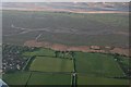
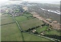
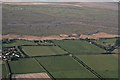
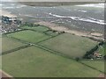
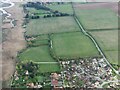
A field marks the site of the Roman fortress of Branodunum. It was built in the 230s and later became part of the Saxon Shore fortification system. See Roman Fortress of Branodunum (Wikipedia).
[Note: the name means 'Fort of the Ravens' and is scheduled as Historic England List ID 1003983, 'Roman fort (Branodunum)'.]
You may be viewing yesterday's version of this page. To see the most up to date information please register for a free account.
Do not use the above information on other web sites or publications without permission of the contributor.
Nearby Images from Geograph Britain and Ireland:
©2018(licence)
©2024(licence)
©2018(licence)
©2024(licence)
©2024(licence)
The above images may not be of the site on this page, they are loaded from Geograph.
Please Submit an Image of this site or go out and take one for us!
Click here to see more info for this site
Nearby sites
Key: Red: member's photo, Blue: 3rd party photo, Yellow: other image, Green: no photo - please go there and take one, Grey: site destroyed
Download sites to:
KML (Google Earth)
GPX (GPS waypoints)
CSV (Garmin/Navman)
CSV (Excel)
To unlock full downloads you need to sign up as a Contributory Member. Otherwise downloads are limited to 50 sites.
Turn off the page maps and other distractions
Nearby sites listing. In the following links * = Image available
2.2km E 85° Burnham Deepdale* Early Christian Sculptured Stone (TF804443)
4.8km ESE 116° Burnham Market* Round Barrow(s) (TF826421)
5.8km WSW 258° Beacon Hill (Norfolk) Ancient Village or Settlement (TF72534255)
7.1km ESE 103° Leath House Roman Barrow* Barrow Cemetery (TF852427)
7.1km WNW 282° Holme II* Timber Circle (TF712453)
7.2km WNW 282° Seahenge* Timber Circle (TF711452)
9.3km E 90° Holkham Camp* Hillfort (TF875443)
11.0km SE 145° South Creake* Hillfort (TF848352)
11.1km SW 226° Sedgeford Iron Age Settlement* Ancient Village or Settlement (TF705360)
13.4km S 185° Bircham Common Barrows* Barrow Cemetery (TF775306)
14.3km SSE 161° Coxford Heath Barrow Round Barrow(s) (TF83493070)
14.4km SSE 159° Wicken Covert Barrow Round Barrow(s) (TF83973081)
15.5km SSW 192° Harpley Common Barrow Cemetery* Barrow Cemetery (TF755287)
16.4km ESE 103° Warham Camp* Hillfort (TF94374089)
16.9km ESE 117° Our Lady of Walsingham Holy Well* Holy Well or Sacred Spring (TF9355136894)
17.0km ESE 117° Little Walsingham Holy Well* Holy Well or Sacred Spring (TF93603678)
17.8km S 173° West Rudham North* Long Barrow (TF810264)
17.9km S 173° West Rudham South* Long Barrow (TF810263)
18.1km ESE 102° Fiddler's Hill (Norfolk)* Round Barrow(s) (TF96134105)
18.8km S 174° West Rudham Cursus Cursus (TF810254)
19.4km S 172° West Rudham* Round Barrow(s) (TF81652495)
23.6km E 93° Blakeney Downs Barrows Round Barrow(s) (TG01864365)
24.8km SSE 149° Whissonsett wheel-head cross* Ancient Cross (TF91922334)
25.1km SSE 163° Litcham Heath* Round Barrow(s) (TF863202)
25.2km SSE 166° Weasenham Plantation* Barrow Cemetery (TF853198)
View more nearby sites and additional images


 We would like to know more about this location. Please feel free to add a brief description and any relevant information in your own language.
 Wir möchten mehr über diese Stätte erfahren. Bitte zögern Sie nicht, eine kurze Beschreibung und relevante Informationen in Deutsch hinzuzufügen.
 Nous aimerions en savoir encore un peu sur les lieux. S'il vous plaît n'hesitez pas à ajouter une courte description et tous les renseignements pertinents dans votre propre langue.
 Quisieramos informarnos un poco más de las lugares. No dude en añadir una breve descripción y otros datos relevantes en su propio idioma.