<< Our Photo Pages >> Hatfield Forest Puddingstones - Natural Stone / Erratic / Other Natural Feature in England in Essex
Submitted by Thorgrim on Sunday, 14 December 2003 Page Views: 8164
Natural PlacesSite Name: Hatfield Forest PuddingstonesCountry: England
NOTE: This site is 3.237 km away from the location you searched for.
County: Essex Type: Natural Stone / Erratic / Other Natural Feature
Nearest Town: Bishop's Stortford Nearest Village: Hatfield
Map Ref: TL541198 Landranger Map Number: 167
Latitude: 51.855518N Longitude: 0.236169E
Condition:
| 5 | Perfect |
| 4 | Almost Perfect |
| 3 | Reasonable but with some damage |
| 2 | Ruined but still recognisable as an ancient site |
| 1 | Pretty much destroyed, possibly visible as crop marks |
| 0 | No data. |
| -1 | Completely destroyed |
| 5 | Superb |
| 4 | Good |
| 3 | Ordinary |
| 2 | Not Good |
| 1 | Awful |
| 0 | No data. |
| 5 | Can be driven to, probably with disabled access |
| 4 | Short walk on a footpath |
| 3 | Requiring a bit more of a walk |
| 2 | A long walk |
| 1 | In the middle of nowhere, a nightmare to find |
| 0 | No data. |
| 5 | co-ordinates taken by GPS or official recorded co-ordinates |
| 4 | co-ordinates scaled from a detailed map |
| 3 | co-ordinates scaled from a bad map |
| 2 | co-ordinates of the nearest village |
| 1 | co-ordinates of the nearest town |
| 0 | no data |
Internal Links:
External Links:
")
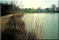
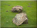
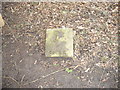
Three puddingstones lie by the lakeside in Hatfield Forest. They were moved when the Old Woman's Weaver was dammed to form the lake. It is claimed that the stones were part of an alignment from Hatfield to Wandlebury via the Newport Leper Stone, Mutlow and Littlebury. (see Sacred Stones of Essex).
You may be viewing yesterday's version of this page. To see the most up to date information please register for a free account.
")
")
Do not use the above information on other web sites or publications without permission of the contributor.
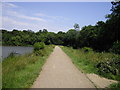
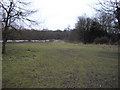
Nearby Images from Geograph Britain and Ireland:
©2018(licence)
©2009(licence)
©2012(licence)
©2009(licence)
©2009(licence)
The above images may not be of the site on this page, they are loaded from Geograph.
Please Submit an Image of this site or go out and take one for us!
Click here to see more info for this site
Nearby sites
Key: Red: member's photo, Blue: 3rd party photo, Yellow: other image, Green: no photo - please go there and take one, Grey: site destroyed
Download sites to:
KML (Google Earth)
GPX (GPS waypoints)
CSV (Garmin/Navman)
CSV (Excel)
To unlock full downloads you need to sign up as a Contributory Member. Otherwise downloads are limited to 50 sites.
Turn off the page maps and other distractions
Nearby sites listing. In the following links * = Image available
1.1km NW 306° Hatfield Forest* Ancient Village or Settlement (TL532204)
2.4km ENE 57° Stansted Airport Stone* Natural Stone / Erratic / Other Natural Feature (TL561212)
4.5km NW 313° Birchanger* Early Christian Sculptured Stone (TL507228)
5.2km WSW 249° Wallbury Camp* Hillfort (TL493178)
5.3km WNW 287° Glasscock Stone* Natural Stone / Erratic / Other Natural Feature (TL4894821169)
7.5km N 349° Ugley Green Puddingstone* Natural Stone / Erratic / Other Natural Feature (TL5242327126)
8.8km NE 43° Tilty Puddingstone* Natural Stone / Erratic / Other Natural Feature (TL599264)
10.6km SW 218° Harlow Barrow* Round Barrow(s) (TL478112)
10.7km SSE 161° Beauchamp Roding Puddingstone* Marker Stone (TL578098)
10.7km SW 218° Harlow Cursus Cursus (TL477112)
10.7km SW 218° Matching Cursus Cursus (TL47791113)
11.2km S 189° High Laver Puddingstone* Natural Stone / Erratic / Other Natural Feature (TL527087)
11.8km SSW 195° Magdalen Laver Puddingstone* Marker Stone (TL513083)
12.0km W 280° Caley Wood Misc. Earthwork (TL422215)
12.4km N 358° Widdington Puddingstone* Natural Stone / Erratic / Other Natural Feature (TL532322)
13.5km N 6° Debden Pudding Stone* Natural Stone / Erratic / Other Natural Feature (TL550333)
13.6km E 94° Felsted Misc. Earthwork (TL677193)
13.8km N 353° Newport Puddingstone* Natural Stone / Erratic / Other Natural Feature (TL521335)
13.9km N 349° Wicken Bonhunt Puddingstone* Natural Stone / Erratic / Other Natural Feature (TL511334)
14.0km NNW 332° Clavering Castle* Misc. Earthwork (TL471319)
14.6km SSW 205° Canes Puddingstone Marker Stone (TL483064)
15.2km SSE 154° Watling Street* Ancient Trackway (TL611063)
15.2km N 354° Leper Stone* Standing Stone (Menhir) (TL520349)
15.3km WNW 282° Standon Puddingstone* Standing Stone (Menhir) (TL390224)
15.3km NW 317° Brent Pelham* Natural Stone / Erratic / Other Natural Feature (TL433307)
View more nearby sites and additional images


 We would like to know more about this location. Please feel free to add a brief description and any relevant information in your own language.
 Wir möchten mehr über diese Stätte erfahren. Bitte zögern Sie nicht, eine kurze Beschreibung und relevante Informationen in Deutsch hinzuzufügen.
 Nous aimerions en savoir encore un peu sur les lieux. S'il vous plaît n'hesitez pas à ajouter une courte description et tous les renseignements pertinents dans votre propre langue.
 Quisieramos informarnos un poco más de las lugares. No dude en añadir una breve descripción y otros datos relevantes en su propio idioma.