

<< Our Photo Pages >> Wicken Fen - Natural Stone / Erratic / Other Natural Feature in England in Cambridgeshire
Submitted by Andy B on Saturday, 15 January 2005 Page Views: 9859
Mesolithic, Palaeolithic and EarlierSite Name: Wicken FenCountry: England
NOTE: This site is 6.528 km away from the location you searched for.
County: Cambridgeshire Type: Natural Stone / Erratic / Other Natural Feature
Map Ref: TL563705
Latitude: 52.310368N Longitude: 0.291301E
Condition:
| 5 | Perfect |
| 4 | Almost Perfect |
| 3 | Reasonable but with some damage |
| 2 | Ruined but still recognisable as an ancient site |
| 1 | Pretty much destroyed, possibly visible as crop marks |
| 0 | No data. |
| -1 | Completely destroyed |
| 5 | Superb |
| 4 | Good |
| 3 | Ordinary |
| 2 | Not Good |
| 1 | Awful |
| 0 | No data. |
| 5 | Can be driven to, probably with disabled access |
| 4 | Short walk on a footpath |
| 3 | Requiring a bit more of a walk |
| 2 | A long walk |
| 1 | In the middle of nowhere, a nightmare to find |
| 0 | No data. |
| 5 | co-ordinates taken by GPS or official recorded co-ordinates |
| 4 | co-ordinates scaled from a detailed map |
| 3 | co-ordinates scaled from a bad map |
| 2 | co-ordinates of the nearest village |
| 1 | co-ordinates of the nearest town |
| 0 | no data |
Internal Links:
External Links:
I have visited· I would like to visit
taysMP would like to visit
Andy B has visited here
")
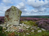
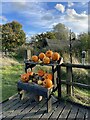
Britain’s oldest nature reserve. Listed here as there is some fascinating 4200 year old bog oak in the cafe area that was found in nearby Adventurer's Fen. See the information board in the photo below for more details.
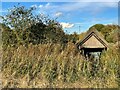
Wicken Fen is a unique fragment of the wilderness that once covered East Anglia, the Fen is a haven for birds, plants, insects and mammals alike. It can be explored by the traditional wide droves and lush green paths, including a boardwalk nature trail, giving access to several hides. The William Thorpe Visitor Centre provides a range of facilities and information about this fascinating place, which has now embarked on an ambitious expansion plan for the next 100 years.
More on their web site or the main National Trust web site
You may be viewing yesterday's version of this page. To see the most up to date information please register for a free account.
")
Do not use the above information on other web sites or publications without permission of the contributor.
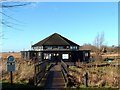
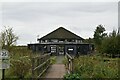
Nearby Images from Geograph Britain and Ireland:
©2021(licence)
©2009(licence)
©2021(licence)
©2021(licence)
©2021(licence)
The above images may not be of the site on this page, they are loaded from Geograph.
Please Submit an Image of this site or go out and take one for us!
Click here to see more info for this site
Nearby sites
Key: Red: member's photo, Blue: 3rd party photo, Yellow: other image, Green: no photo - please go there and take one, Grey: site destroyed
Download sites to:
KML (Google Earth)
GPX (GPS waypoints)
CSV (Garmin/Navman)
CSV (Excel)
To unlock full downloads you need to sign up as a Contributory Member. Otherwise downloads are limited to 50 sites.
Turn off the page maps and other distractions
Nearby sites listing. In the following links * = Image available
4.8km SSE 161° The Burwells* Holy Well or Sacred Spring (TL5866)
6.1km SSE 166° Devil's Dyke, Cambridgeshire* Misc. Earthwork (TL580646)
8.7km SSW 192° Bottisham Cursus Cursus (TL547619)
13.4km ESE 102° Howe Hill Bowl Barrow* Round Barrow(s) (TL69536822)
13.9km W 271° Belsar's Hill* Hillfort (TL424703)
14.3km NW 325° Wardy Hill* Hillfort (TL478820)
14.7km NW 307° Sutton in the Isle Round Barrow Round Barrow(s) (TL443790)
15.4km WNW 283° Haddenham Enclosure Causewayed Enclosure (TL412736)
15.5km WNW 295° Haddenham Long Barrow (TL420767)
16.2km S 188° Mutlow Hill* Round Barrow(s) (TL5466354380)
16.2km SSW 210° The Kingship Stone, Cherry Hinton Natural Stone / Erratic / Other Natural Feature (TL486562)
16.6km WSW 256° St Michael's Well (Cambridge)* Holy Well or Sacred Spring (TL40326584)
16.7km SW 224° Cambridge Museum of Archaeology & Anthropology* Museum (TL450581)
16.9km SSW 209° East Pit Nature Reserve* Ancient Village or Settlement (TL485555)
16.9km SW 224° Cambridge Fitzwilliam Museum* Museum (TL44955790)
18.3km SSW 199° Copley Hill* Round Barrow(s) (TL509530)
18.5km SSW 204° Wandlebury* Hillfort (TL493534)
18.5km SSW 204° Gog and Magog Giants Hill Figures* Hill Figure or Geoglyph (TL492534)
18.7km SSW 198° Babraham* Long Barrow (TL510526)
18.9km SSW 202° Wormwood Hill* Round Barrow(s) (TL497528)
19.1km SSW 213° Nine wells* Holy Well or Sacred Spring (TL46305420)
20.4km ENE 75° How Hill Round Barrow(s) (TL75987626)
21.8km SSW 212° Little Shelford Crosses* Ancient Cross (TL453516)
22.6km W 272° Holywell (Cambridgeshire)* Holy Well or Sacred Spring (TL336707)
22.9km W 270° Low Hill Bowl Barrow, Fen Drayton RSPB Reserve* Round Barrow(s) (TL33336960)
View more nearby sites and additional images


 We would like to know more about this location. Please feel free to add a brief description and any relevant information in your own language.
 Wir möchten mehr über diese Stätte erfahren. Bitte zögern Sie nicht, eine kurze Beschreibung und relevante Informationen in Deutsch hinzuzufügen.
 Nous aimerions en savoir encore un peu sur les lieux. S'il vous plaît n'hesitez pas à ajouter une courte description et tous les renseignements pertinents dans votre propre langue.
 Quisieramos informarnos un poco más de las lugares. No dude en añadir una breve descripción y otros datos relevantes en su propio idioma.