<< Our Photo Pages >> Mortotum - Ancient Village or Settlement in Spain in Comunidad Valenciana
Submitted by Maatje on Tuesday, 26 March 2024 Page Views: 80
Multi-periodSite Name: MortotumCountry: Spain
NOTE: This site is 21.026 km away from the location you searched for.
Region: Comunidad Valenciana Type: Ancient Village or Settlement
Nearest Town: Catellón de la Plana Nearest Village: Cabanes
Latitude: 40.140794N Longitude: 0.106292E
Condition:
| 5 | Perfect |
| 4 | Almost Perfect |
| 3 | Reasonable but with some damage |
| 2 | Ruined but still recognisable as an ancient site |
| 1 | Pretty much destroyed, possibly visible as crop marks |
| 0 | No data. |
| -1 | Completely destroyed |
| 5 | Superb |
| 4 | Good |
| 3 | Ordinary |
| 2 | Not Good |
| 1 | Awful |
| 0 | No data. |
| 5 | Can be driven to, probably with disabled access |
| 4 | Short walk on a footpath |
| 3 | Requiring a bit more of a walk |
| 2 | A long walk |
| 1 | In the middle of nowhere, a nightmare to find |
| 0 | No data. |
| 5 | co-ordinates taken by GPS or official recorded co-ordinates |
| 4 | co-ordinates scaled from a detailed map |
| 3 | co-ordinates scaled from a bad map |
| 2 | co-ordinates of the nearest village |
| 1 | co-ordinates of the nearest town |
| 0 | no data |
Internal Links:
External Links:
")
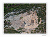
Tumulus from the Bronzeage; Remains of at least 5 people were found.
Discovered in 2006, its form is unique in the area.
Settlement houses, artifacts of trading with Phoenicians - metallic objects as lead, iron, and other alloys - bracelets and pottery were found.
Medium strength walk to the top of the mountain, 85 meter level. Distance 1.1 km.
Panorama over the see and landscape.
You may be viewing yesterday's version of this page. To see the most up to date information please register for a free account.
")
Do not use the above information on other web sites or publications without permission of the contributor.
Nearby Images from Flickr


The above images may not be of the site on this page, but were taken nearby. They are loaded from Flickr so please click on them for image credits.
Click here to see more info for this site
Nearby sites
Click here to view sites on an interactive map of the areaKey: Red: member's photo, Blue: 3rd party photo, Yellow: other image, Green: no photo - please go there and take one, Grey: site destroyed
Download sites to:
KML (Google Earth)
GPX (GPS waypoints)
CSV (Garmin/Navman)
CSV (Excel)
To unlock full downloads you need to sign up as a Contributory Member. Otherwise downloads are limited to 50 sites.
Turn off the page maps and other distractions
Nearby sites listing. In the following links * = Image available
36.4km NNW 328° Cingle de la Mola* Cave or Rock Shelter
36.5km NNW 328° Cueva Remigia* Cave or Rock Shelter
53.1km NNW 339° L'Argilagar VI Ancient Village or Settlement
53.1km NNW 339° L'Argilagar II Burial Chamber or Dolmen
53.1km NNW 339° L'Argilagar I Burial Chamber or Dolmen
55.4km NNW 342° Argilagar Castro or Chafurdão
56.3km NE 34° Poblat Ibèric de la Moleta del Remei Ancient Village or Settlement
61.1km SSW 213° Seguntum* Ancient Village or Settlement
84.7km SSW 210° Museu de Prehistòria de València* Museum
90.4km N 4° Cista protohistòrica de Querete Burial Chamber or Dolmen
90.8km N 4° Cretas Cuevas* Cave or Rock Shelter
96.3km N 4° Poblado Ibérico de San Antonio Ancient Village or Settlement
101.0km N 349° Cabezo Sellado Castro or Chafurdão
102.8km N 350° Palao Castro or Chafurdão
103.6km NNE 13° Necrópolis Protohistòrica Del Coll del Moro* Barrow Cemetery
104.6km WNW 282° Rodenas Castro or Chafurdão
104.7km WSW 248° Cueva de la Vieja* Cave or Rock Shelter
107.8km W 279° Penalba de Villastar Castro or Chafurdão
115.0km NW 314° Rio Martin Castro or Chafurdão
120.6km NNW 334° Albate del Arzobispo Castro or Chafurdão
122.7km W 280° Pena de la Cruz Castro or Chafurdão
126.5km NE 36° La Roca Castro or Chafurdão
130.1km NE 37° Villa Romana de la Llosa* Ancient Village or Settlement
130.5km SSW 194° Parpalló Cave* Cave or Rock Shelter
130.5km WNW 283° Arte rupestre en Albarracín* Cave or Rock Shelter
View more nearby sites and additional images


 We would like to know more about this location. Please feel free to add a brief description and any relevant information in your own language.
 Wir möchten mehr über diese Stätte erfahren. Bitte zögern Sie nicht, eine kurze Beschreibung und relevante Informationen in Deutsch hinzuzufügen.
 Nous aimerions en savoir encore un peu sur les lieux. S'il vous plaît n'hesitez pas à ajouter une courte description et tous les renseignements pertinents dans votre propre langue.
 Quisieramos informarnos un poco más de las lugares. No dude en añadir una breve descripción y otros datos relevantes en su propio idioma.