<< Text Pages >> Samabaj - Ancient Temple in Guatemala
Submitted by bat400 on Wednesday, 18 November 2009 Page Views: 9092
Multi-periodSite Name: SamabajCountry: Guatemala
NOTE: This site is 30.301 km away from the location you searched for.
Type: Ancient Temple
Nearest Village: Santiago Atitlan
Latitude: 14.680000N Longitude: 91.213W
Condition:
| 5 | Perfect |
| 4 | Almost Perfect |
| 3 | Reasonable but with some damage |
| 2 | Ruined but still recognisable as an ancient site |
| 1 | Pretty much destroyed, possibly visible as crop marks |
| 0 | No data. |
| -1 | Completely destroyed |
| 5 | Superb |
| 4 | Good |
| 3 | Ordinary |
| 2 | Not Good |
| 1 | Awful |
| 0 | No data. |
| 5 | Can be driven to, probably with disabled access |
| 4 | Short walk on a footpath |
| 3 | Requiring a bit more of a walk |
| 2 | A long walk |
| 1 | In the middle of nowhere, a nightmare to find |
| 0 | No data. |
| 5 | co-ordinates taken by GPS or official recorded co-ordinates |
| 4 | co-ordinates scaled from a detailed map |
| 3 | co-ordinates scaled from a bad map |
| 2 | co-ordinates of the nearest village |
| 1 | co-ordinates of the nearest town |
| 0 | no data |
Internal Links:
External Links:
Ancient Temple in Guatemala.The first underwater archaeological ruins excavated in Guatemala, Samabaj was discovered in 1996 by Roberto Samayoa, a businessman and recreational diver, while exploring Lake Atitlan. Recently professional archeologists taken an interest, mapping the 4,300-square-foot (400-square-meter) area with sonar technology and excavating structures on a raised part of the lake bed.
This area, 50 feet below the lake's surface, is thought to have been an island until water levels rose. (Water levels in the volcanic lake have continued to fluctuate into modern times as well.) Pre-classical (ca. 250 AD) Mayan ceramics, ceremonial monuments and altars have been found.
The murky water and thick layers of sediment have impeded excavations. The exact location of the site is a closely guarded secret to protect it from looters. The location given is only approximate for the general area.
Note: Divers probe Mayan ruins submerged in Guatemala lake.
You may be viewing yesterday's version of this page. To see the most up to date information please register for a free account.
Do not use the above information on other web sites or publications without permission of the contributor.
Nearby Images from Flickr
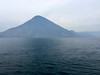
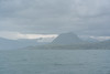
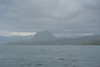

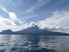
The above images may not be of the site on this page, but were taken nearby. They are loaded from Flickr so please click on them for image credits.
Click here to see more info for this site
Nearby sites
Click here to view sites on an interactive map of the areaKey: Red: member's photo, Blue: 3rd party photo, Yellow: other image, Green: no photo - please go there and take one, Grey: site destroyed
Download sites to:
KML (Google Earth)
GPX (GPS waypoints)
CSV (Garmin/Navman)
CSV (Excel)
To unlock full downloads you need to sign up as a Contributory Member. Otherwise downloads are limited to 50 sites.
Turn off the page maps and other distractions
Nearby sites listing. In the following links * = Image available
24.2km ENE 75° Iximche' * Ancient Village or Settlement
56.3km W 265° Tak'alik Ab'aj* Ancient Village or Settlement
71.7km E 94° Kaminaljuyu* Ancient Village or Settlement
74.1km E 97° Museum of Archaeology and Ethnology (Guatemala City)* Museum
78.6km NNW 338° Zaculeu* Ancient Village or Settlement
100.9km NNW 336° Tecumanchu* Ancient Temple
107.4km WNW 285° Izapa* Ancient Village or Settlement
129.3km W 281° Ojo de Agua Carving
146.5km NNW 331° Lagartero Ancient Village or Settlement
171.1km NNW 346° Nuevo Ojo de Agua Cave Cave or Rock Shelter
172.0km NNW 339° Chinkultic* Ancient Village or Settlement
182.9km ESE 115° Casa Blanca Ancient Village or Settlement
183.2km ESE 115° Tazumal* Ancient Village or Settlement
188.6km NNW 330° Tenam Puente* Ancient Village or Settlement
194.4km NE 40° Cancuen* Ancient Village or Settlement
219.2km NNE 29° Aguateca* Ancient Village or Settlement
219.5km ESE 116° San Andres* Ancient Village or Settlement
219.6km NNE 26° Dos Pilas* Ancient Village or Settlement
221.4km ESE 115° Joya de Ceren* Ancient Village or Settlement
223.4km E 85° Copa'n* Ancient Village or Settlement
225.9km N 4° Bonampak* Ancient Village or Settlement
234.2km N 358° Plan de Ayutla* Ancient Village or Settlement
238.1km NNE 31° Ceibal* Ancient Village or Settlement
242.5km ENE 74° Quirigua* Ancient Village or Settlement
248.3km N 6° Yaxchilan* Ancient Village or Settlement
View more nearby sites and additional images


 We would like to know more about this location. Please feel free to add a brief description and any relevant information in your own language.
 Wir möchten mehr über diese Stätte erfahren. Bitte zögern Sie nicht, eine kurze Beschreibung und relevante Informationen in Deutsch hinzuzufügen.
 Nous aimerions en savoir encore un peu sur les lieux. S'il vous plaît n'hesitez pas à ajouter une courte description et tous les renseignements pertinents dans votre propre langue.
 Quisieramos informarnos un poco más de las lugares. No dude en añadir una breve descripción y otros datos relevantes en su propio idioma.