

<< Other Photo Pages >> Glass Mounds (Mississippi) - Artificial Mound in United States in The South
Submitted by stonetracker on Friday, 03 February 2023 Page Views: 1432
Pre-ColumbianSite Name: Glass Mounds (Mississippi)Country: United States
NOTE: This site is 7.953 km away from the location you searched for.
Region: The South Type: Artificial Mound
Nearest Town: Letourneau MS
Latitude: 32.230100N Longitude: 90.93605W
Condition:
| 5 | Perfect |
| 4 | Almost Perfect |
| 3 | Reasonable but with some damage |
| 2 | Ruined but still recognisable as an ancient site |
| 1 | Pretty much destroyed, possibly visible as crop marks |
| 0 | No data. |
| -1 | Completely destroyed |
| 5 | Superb |
| 4 | Good |
| 3 | Ordinary |
| 2 | Not Good |
| 1 | Awful |
| 0 | No data. |
| 5 | Can be driven to, probably with disabled access |
| 4 | Short walk on a footpath |
| 3 | Requiring a bit more of a walk |
| 2 | A long walk |
| 1 | In the middle of nowhere, a nightmare to find |
| 0 | No data. |
| 5 | co-ordinates taken by GPS or official recorded co-ordinates |
| 4 | co-ordinates scaled from a detailed map |
| 3 | co-ordinates scaled from a bad map |
| 2 | co-ordinates of the nearest village |
| 1 | co-ordinates of the nearest town |
| 0 | no data |
Internal Links:
External Links:
I have visited· I would like to visit
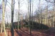
stonetracker visited - their rating: Cond: 3 Amb: 3 There is a parking pulloff on US Route 61 with site interpretation. However, the mounds are not walking-accessible from Route 61 and two of them (A and D) can only be viewed at a long distance from that highway (the remaining mounds were destroyed some time ago). It may be possible to see the same mounds at much closer range via back roads and a rail line, but I did not investigate.
 (PID:266799)")
Mound A currently stands at 30 feet high and has a ramp extending south toward the plaza. Recent professional archaeological excavations uncovered the remains of two wattle and daub structures associated with the final summit occupation of Mound A. These buildings were likely the homes of powerful Native American political or religious leaders. Both structures were burned to the ground upon abandonment and the remains were capped by a layer of mound fill sometime during the 16th or early 17th century. The practice of burning and burying mound-top structures is common for this time period and may have happened upon the death of the persons who lived in them.
Much less is known about the remaining mounds, but we do know that Mounds B and C were both used for burial of the dead. A local avocational archaeologist recorded three stratigraphic layers of Mound C's eroded southern face before its destruction in 1973. The earliest of these was a "burial layer," followed by a thin band of yellow soil and then covered by a layer of basket-loaded mound fill. Several notable artifacts also came from Mound C, including pottery, celts, stone palettes, and a limestone human effigy pipe. The pipe and a number of pottery vessels are currently on display at the Old Courthouse Museum in Vicksburg.
The location coordinates given are for Mound A.
For more info, see trails.mdah.ms.gov/mmt/glass/index.html
You may be viewing yesterday's version of this page. To see the most up to date information please register for a free account.
 (PID:266801)")
 (PID:262295)")
 (PID:262294)")
 (PID:261719)")
Do not use the above information on other web sites or publications without permission of the contributor.
Nearby Images from Flickr

The above images may not be of the site on this page, but were taken nearby. They are loaded from Flickr so please click on them for image credits.
Click here to see more info for this site
Nearby sites
Click here to view sites on an interactive map of the areaKey: Red: member's photo, Blue: 3rd party photo, Yellow: other image, Green: no photo - please go there and take one, Grey: site destroyed
Download sites to:
KML (Google Earth)
GPX (GPS waypoints)
CSV (Garmin/Navman)
CSV (Excel)
To unlock full downloads you need to sign up as a Contributory Member. Otherwise downloads are limited to 50 sites.
Turn off the page maps and other distractions
Nearby sites listing. In the following links * = Image available
16.9km NW 307° Fitzhugh Mounds* Artificial Mound
20.5km NNE 22° Kings Crossing Mounds* Artificial Mound
26.6km S 173° Mangum Mound* Artificial Mound
28.3km SSW 193° Bayou Pierre Mounds* Artificial Mound
30.6km NW 308° Schicker Mound Artificial Mound
30.7km WSW 249° Balmoral Mounds* Artificial Mound
35.4km WSW 256° Shackleford Church Mounds Artificial Mound
35.8km NNE 24° Haynes Bluff Mounds* Artificial Mound
36.3km SSW 210° Windsor Mounds* Artificial Mound
45.1km SW 225° Flowery Mound* Artificial Mound
46.3km NNE 12° Aden Mounds* Artificial Mound
46.4km WNW 299° Tendal Mound* Artificial Mound
46.9km SW 226° Mound Plantation Artificial Mound
50.8km WSW 253° Ghost Site Mounds Artificial Mound
52.1km SW 236° Mayflower Mound Artificial Mound
53.9km WNW 289° Insley Mounds* Artificial Mound
56.1km SW 234° Sundown Mounds Artificial Mound
56.6km NNW 334° Transylvania Mound* Artificial Mound
57.4km NNW 333° Julice Mound Artificial Mound
59.4km WNW 299° Marsden Mounds* Artificial Mound
61.4km NW 314° Lower Jackson* Artificial Mound
63.0km NW 316° Poverty Point* Ancient Village or Settlement
63.1km NW 316° Poverty Point - Earthworks* Ancient Village or Settlement
63.4km NW 315° Poverty Point - Mound A* Artificial Mound
63.8km N 0° Cary Mounds* Artificial Mound
View more nearby sites and additional images


 We would like to know more about this location. Please feel free to add a brief description and any relevant information in your own language.
 Wir möchten mehr über diese Stätte erfahren. Bitte zögern Sie nicht, eine kurze Beschreibung und relevante Informationen in Deutsch hinzuzufügen.
 Nous aimerions en savoir encore un peu sur les lieux. S'il vous plaît n'hesitez pas à ajouter une courte description et tous les renseignements pertinents dans votre propre langue.
 Quisieramos informarnos un poco más de las lugares. No dude en añadir una breve descripción y otros datos relevantes en su propio idioma.