


<< Our Photo Pages >> Lough Scannaimh - Crannog in Ireland (Republic of) in Co. Galway
Submitted by damian120 on Tuesday, 22 May 2018 Page Views: 1852
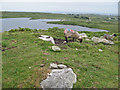
Iron Age and Later PrehistorySite Name: Lough ScannaimhCountry: Ireland (Republic of)
NOTE: This site is 8.286 km away from the location you searched for.
County: Co. Galway Type: Crannog
Nearest Town: Carna Nearest Village: Carna
Latitude: 53.322000N Longitude: 9.791W
Condition:
| 5 | Perfect |
| 4 | Almost Perfect |
| 3 | Reasonable but with some damage |
| 2 | Ruined but still recognisable as an ancient site |
| 1 | Pretty much destroyed, possibly visible as crop marks |
| 0 | No data. |
| -1 | Completely destroyed |
| 5 | Superb |
| 4 | Good |
| 3 | Ordinary |
| 2 | Not Good |
| 1 | Awful |
| 0 | No data. |
| 5 | Can be driven to, probably with disabled access |
| 4 | Short walk on a footpath |
| 3 | Requiring a bit more of a walk |
| 2 | A long walk |
| 1 | In the middle of nowhere, a nightmare to find |
| 0 | No data. |
| 5 | co-ordinates taken by GPS or official recorded co-ordinates |
| 4 | co-ordinates scaled from a detailed map |
| 3 | co-ordinates scaled from a bad map |
| 2 | co-ordinates of the nearest village |
| 1 | co-ordinates of the nearest town |
| 0 | no data |
Internal Links:
External Links:
")
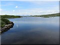
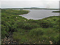
Said to be the best preserved Crannog in Connemara. A picture-postcard setting with the mountain backdrop.
You may be viewing yesterday's version of this page. To see the most up to date information please register for a free account.
Do not use the above information on other web sites or publications without permission of the contributor.
Nearby Images from Geograph Britain and Ireland:
©2012(licence)
©2013(licence)
©2012(licence)
©2013(licence)
©2013(licence)
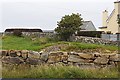
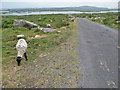
The above images may not be of the site on this page, they are loaded from Geograph.
Please Submit an Image of this site or go out and take one for us!
Click here to see more info for this site
Nearby sites
Click here to view sites on an interactive map of the areaKey: Red: member's photo, Blue: 3rd party photo, Yellow: other image, Green: no photo - please go there and take one, Grey: site destroyed
Download sites to:
KML (Google Earth)
GPX (GPS waypoints)
CSV (Garmin/Navman)
CSV (Excel)
To unlock full downloads you need to sign up as a Contributory Member. Otherwise downloads are limited to 50 sites.
Turn off the page maps and other distractions
Nearby sites listing. In the following links * = Image available
13.7km ESE 120° Oorid Standing Stones (L924245)
19.5km S 177° High Cross (Teampall Bhreacain)* Ancient Cross
19.6km S 177° Na Seacht dTeampaill* Early Christian Sculptured Stone
20.2km S 174° Clochan na Carraige* Ancient Village or Settlement (L823115)
20.2km S 177° Dun Eoghanachta* Stone Fort or Dun (L812114)
20.3km S 179° Clochan Chambered Cairn
20.6km N 9° Lough Inagh Crannog
21.3km S 174° Ogham stone at Kilmurvy* Standing Stone (Menhir) (L8241410412)
21.5km S 173° Dún Aengus Inishmore Island Promontory Fort / Cliff Castle
21.9km S 176° Dun Aengus* Stone Fort or Dun (L817098)
21.9km NNW 332° Cregg Lough Well Holy Well or Sacred Spring
22.2km SSE 167° Oghil Wedge Tomb* Wedge Tomb (L84980988)
22.3km SSE 161° Chiaráin stones* Holed Stone
22.5km SSE 164° Dún Eochla wedge tomb* Wedge Tomb (L8620409853)
22.5km SSE 164° Dun Eochla* Stone Fort or Dun (L863098)
23.2km NNW 328° Lough Ouashleen Burial Chamber or Dolmen
23.5km N 0° Gleninagh Stone Row / Alignment (L815552)
24.1km NNW 330° Lough Auna Tomb Burial Chamber or Dolmen
24.9km NNE 17° Poundcarton Stone Row / Alignment (L887553)
25.0km NNE 20° Maumgawnagh Barrow Round Barrow(s) (L899549)
25.1km NNE 25° Maumgawnagh* Standing Stone (Menhir)
25.1km SSE 164° Dun Ducathair* Stone Fort or Dun (L870073)
25.2km NW 319° Clifden Cist Cist
25.4km NNE 21° Knockanbaun* Standing Stones
25.5km NW 317° D'Arcy Stones 2* Modern Stone Circle etc
View more nearby sites and additional images


 We would like to know more about this location. Please feel free to add a brief description and any relevant information in your own language.
 Wir möchten mehr über diese Stätte erfahren. Bitte zögern Sie nicht, eine kurze Beschreibung und relevante Informationen in Deutsch hinzuzufügen.
 Nous aimerions en savoir encore un peu sur les lieux. S'il vous plaît n'hesitez pas à ajouter une courte description et tous les renseignements pertinents dans votre propre langue.
 Quisieramos informarnos un poco más de las lugares. No dude en añadir una breve descripción y otros datos relevantes en su propio idioma.