<< Text Pages >> The Inchagoill Stone - Early Christian Sculptured Stone in Ireland (Republic of) in Co. Mayo
Submitted by Sunny100 on Tuesday, 05 October 2010 Page Views: 10573
Early Medieval (Dark Age)Site Name: The Inchagoill Stone Alternative Name: The Luguaedon Stone, St Patrick's StoneCountry: Ireland (Republic of)
NOTE: This site is 14.885 km away from the location you searched for.
County: Co. Mayo Type: Early Christian Sculptured Stone
Nearest Town: Oughterard
Map Ref: M126494
Latitude: 53.487564N Longitude: 9.317417W
Condition:
| 5 | Perfect |
| 4 | Almost Perfect |
| 3 | Reasonable but with some damage |
| 2 | Ruined but still recognisable as an ancient site |
| 1 | Pretty much destroyed, possibly visible as crop marks |
| 0 | No data. |
| -1 | Completely destroyed |
| 5 | Superb |
| 4 | Good |
| 3 | Ordinary |
| 2 | Not Good |
| 1 | Awful |
| 0 | No data. |
| 5 | Can be driven to, probably with disabled access |
| 4 | Short walk on a footpath |
| 3 | Requiring a bit more of a walk |
| 2 | A long walk |
| 1 | In the middle of nowhere, a nightmare to find |
| 0 | No data. |
| 5 | co-ordinates taken by GPS or official recorded co-ordinates |
| 4 | co-ordinates scaled from a detailed map |
| 3 | co-ordinates scaled from a bad map |
| 2 | co-ordinates of the nearest village |
| 1 | co-ordinates of the nearest town |
| 0 | no data |
Internal Links:
External Links:
Early Christian Sculptured Stone in Co. Mayo
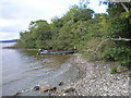
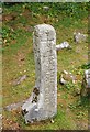
Inchagoille Island (Island of the Foreigner) is located in Lough Corrib some 5 miles N of Oughterard, on the borders of Counties Mayo and Galway. [It can only be reached by boat from Oughterard or Cong]. On the island there is a 5th century Latin inscribed stone and two ruined, roofless churches. St Patrick is thought to have founded a church here in the 5th century CE.
The inscribed stone, at the front of the church, is 75 cm tall and marks the site of an early Christian burial, and probably dates from c500 CE. It has a Latin inscription in memory of LIA LUGUAEDON, son of MACCI MENUEH, who may have been the nephew of St Patrick. This stone is regarded as one of the oldest Christian inscriptions in western Europe.
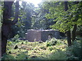
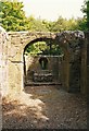
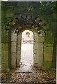
St Patrick's church/oratory (Tempall Phadraig) is ruined and roofless, but has some good Romanesque carvings. A second roofless church called Tempall na Naoimh (Church of the Saints) dates from the 9th-10th century and has some Romanesque carved stone heads around it's arched doorway. Inside, two small cross-incised stones stand against the wall and there are also some carvings on the stonework itself.
You may be viewing yesterday's version of this page. To see the most up to date information please register for a free account.
Do not use the above information on other web sites or publications without permission of the contributor.
Nearby Images from Geograph Britain and Ireland:
©2008(licence)
©2012(licence)
©2005(licence)
©2012(licence)
©2012(licence)
The above images may not be of the site on this page, they are loaded from Geograph.
Please Submit an Image of this site or go out and take one for us!
Click here to see more info for this site
Nearby sites
Click here to view sites on an interactive map of the areaKey: Red: member's photo, Blue: 3rd party photo, Yellow: other image, Green: no photo - please go there and take one, Grey: site destroyed
Download sites to:
KML (Google Earth)
GPX (GPS waypoints)
CSV (Garmin/Navman)
CSV (Excel)
To unlock full downloads you need to sign up as a Contributory Member. Otherwise downloads are limited to 50 sites.
Turn off the page maps and other distractions
Nearby sites listing. In the following links * = Image available
5.4km NNE 24° Cong.* Rock Art (M149543)
7.5km NNE 25° Cong Stones* Standing Stones
7.5km NNE 27° Cong West* Stone Circle
7.5km NNE 28° Cong South* Stone Circle
7.6km NNE 28° Cong Stone Circles Stone Circle
7.7km NNE 28° Cong East* Stone Circle
7.7km NNE 28° Cong North* Stone Circle
7.8km N 3° Dringeen Oughter* Standing Stone (Menhir)
9.5km SSE 151° Ardcorkey Stone Circle (M1741)
10.6km NNE 32° Neale Stone* Standing Stone (Menhir)
12.1km N 360° Inishowen Stone Circle (M128615)
16.0km NE 55° Cregduff* Henge
20.5km NE 40° Carrowreagh* Stone Circle (M2665)
21.4km WNW 282° Maumgawnagh* Standing Stone (Menhir)
23.0km WNW 284° Knockanbaun* Standing Stones
23.3km WNW 283° Maumgawnagh Barrow Round Barrow(s) (L899549)
24.5km WNW 283° Poundcarton Stone Row / Alignment (L887553)
27.9km WNW 292° Leenaun Tomb Burial Chamber or Dolmen
28.1km W 274° Lough Inagh Crannog
29.9km WNW 290° Glencraff Tomb Burial Chamber or Dolmen
30.7km WNW 288° Glencraff Stone Standing Stone (Menhir)
30.7km WNW 288° Glencraff Dun Stone Fort or Dun
31.5km W 280° Gleninagh Stone Row / Alignment (L815552)
32.0km SW 218° Oorid Standing Stones (L924245)
32.9km NNW 332° Boheh* Rock Art (L97517866)
View more nearby sites and additional images


 We would like to know more about this location. Please feel free to add a brief description and any relevant information in your own language.
 Wir möchten mehr über diese Stätte erfahren. Bitte zögern Sie nicht, eine kurze Beschreibung und relevante Informationen in Deutsch hinzuzufügen.
 Nous aimerions en savoir encore un peu sur les lieux. S'il vous plaît n'hesitez pas à ajouter une courte description et tous les renseignements pertinents dans votre propre langue.
 Quisieramos informarnos un poco más de las lugares. No dude en añadir una breve descripción y otros datos relevantes en su propio idioma.