<< Our Photo Pages >> Yaxha - Ancient Village or Settlement in Guatemala
Submitted by bat400 on Monday, 08 February 2010 Page Views: 5012
Multi-periodSite Name: YaxhaCountry: Guatemala
NOTE: This site is 2.29 km away from the location you searched for.
Type: Ancient Village or Settlement
Latitude: 17.070669N Longitude: 89.399884W
Condition:
| 5 | Perfect |
| 4 | Almost Perfect |
| 3 | Reasonable but with some damage |
| 2 | Ruined but still recognisable as an ancient site |
| 1 | Pretty much destroyed, possibly visible as crop marks |
| 0 | No data. |
| -1 | Completely destroyed |
| 5 | Superb |
| 4 | Good |
| 3 | Ordinary |
| 2 | Not Good |
| 1 | Awful |
| 0 | No data. |
| 5 | Can be driven to, probably with disabled access |
| 4 | Short walk on a footpath |
| 3 | Requiring a bit more of a walk |
| 2 | A long walk |
| 1 | In the middle of nowhere, a nightmare to find |
| 0 | No data. |
| 5 | co-ordinates taken by GPS or official recorded co-ordinates |
| 4 | co-ordinates scaled from a detailed map |
| 3 | co-ordinates scaled from a bad map |
| 2 | co-ordinates of the nearest village |
| 1 | co-ordinates of the nearest town |
| 0 | no data |
Internal Links:
External Links:
I have visited· I would like to visit
DrewParsons would like to visit
SolarMegalith visited on 1st Mar 2005 - their rating: Cond: 4 Amb: 5 Access: 3
john_op_stap visited on 11th Apr 2004 - their rating: Cond: 2 Amb: 5 Access: 3 The site is so fantastic to visit due to the presence of the lake and the pristine forest around. We saw many more animals then at eg Tikal. It must have been quite an important place, given that like Tikal certain structures are in Teotihuacan style, which would suppose a permanent trade agency or an ambassador to that Mexican culture resided here.
Average ratings for this site from all visit loggers: Condition: 3 Ambience: 5 Access: 3
")
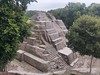
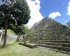
The best preserved, partially reconstructed structure is Temple 216 - from it's top it's possible to see other pyramids and the lake. In Yaxha there are also 40 preserved stelae with Mayan inscriptions. Yaxha is one of the three most important sites in this area - the others are Nakum and El Naranjo. Guided one-day tours from Flores to Yaxha and Nakum are best and most popular way to visit the sites.
You may be viewing yesterday's version of this page. To see the most up to date information please register for a free account.
")
")
")
Do not use the above information on other web sites or publications without permission of the contributor.
Nearby Images from Flickr


The above images may not be of the site on this page, but were taken nearby. They are loaded from Flickr so please click on them for image credits.
Click here to see more info for this site
Nearby sites
Click here to view sites on an interactive map of the areaKey: Red: member's photo, Blue: 3rd party photo, Yellow: other image, Green: no photo - please go there and take one, Grey: site destroyed
Download sites to:
KML (Google Earth)
GPX (GPS waypoints)
CSV (Garmin/Navman)
CSV (Excel)
To unlock full downloads you need to sign up as a Contributory Member. Otherwise downloads are limited to 50 sites.
Turn off the page maps and other distractions
Nearby sites listing. In the following links * = Image available
11.1km SSW 194° Holtun* Ancient Village or Settlement
11.7km N 357° Nakum* Ancient Village or Settlement
16.2km ENE 64° Naranjo* Ancient Village or Settlement
27.5km E 86° Xunantunich* Ancient Village or Settlement
29.7km NW 305° Tikal* Ancient Village or Settlement
30.0km NNE 26° Holmul Ancient Village or Settlement
32.3km WSW 250° Ixlú Ancient Village or Settlement
33.5km SSW 211° Chilonche Ancient Village or Settlement
34.0km NE 53° El Pilar* Ancient Village or Settlement
34.9km E 83° Chaa Creek* Ancient Village or Settlement
35.6km ENE 76° Cahal Pech Ancient Village or Settlement
36.1km NNE 26° Cival Ancient Village or Settlement
43.7km NW 325° Uaxactun* Ancient Village or Settlement
45.4km SE 139° Caracol Ancient Village or Settlement
48.3km WNW 299° El Zotz* Ancient Village or Settlement
50.7km N 10° Xultun Ancient Village or Settlement
53.1km N 360° San Bartolo* Ancient Village or Settlement
54.6km WSW 253° Nojpetén* Ancient Village or Settlement
58.3km WSW 257° Nixtun-Ch'ich' Ancient Village or Settlement
68.5km NE 56° Cara Blanca Natural Stone / Erratic / Other Natural Feature
72.6km ENE 68° Saturday Creek Ancient Village or Settlement
81.3km NW 306° La Florida* Ancient Village or Settlement
82.1km NW 326° Nakbe* Ancient Village or Settlement
85.8km SE 133° Quebrada de Oro Ancient Village or Settlement
93.4km NW 324° El Mirador* Ancient Village or Settlement
View more nearby sites and additional images


 We would like to know more about this location. Please feel free to add a brief description and any relevant information in your own language.
 Wir möchten mehr über diese Stätte erfahren. Bitte zögern Sie nicht, eine kurze Beschreibung und relevante Informationen in Deutsch hinzuzufügen.
 Nous aimerions en savoir encore un peu sur les lieux. S'il vous plaît n'hesitez pas à ajouter une courte description et tous les renseignements pertinents dans votre propre langue.
 Quisieramos informarnos un poco más de las lugares. No dude en añadir una breve descripción y otros datos relevantes en su propio idioma.