<< Text Pages >> Stone of Rock City Park - Natural Stone / Erratic / Other Natural Feature in United States in The South
Submitted by AlexAssa on Saturday, 25 May 2019 Page Views: 7568
Natural PlacesSite Name: Stone of Rock City ParkCountry: United States
NOTE: This site is 103.246 km away from the location you searched for.
Region: The South Type: Natural Stone / Erratic / Other Natural Feature
Nearest Town: Olean Nearest Village: Knapp Creek
Latitude: 42.017855N Longitude: 78.476844W
Condition:
| 5 | Perfect |
| 4 | Almost Perfect |
| 3 | Reasonable but with some damage |
| 2 | Ruined but still recognisable as an ancient site |
| 1 | Pretty much destroyed, possibly visible as crop marks |
| 0 | No data. |
| -1 | Completely destroyed |
| 5 | Superb |
| 4 | Good |
| 3 | Ordinary |
| 2 | Not Good |
| 1 | Awful |
| 0 | No data. |
| 5 | Can be driven to, probably with disabled access |
| 4 | Short walk on a footpath |
| 3 | Requiring a bit more of a walk |
| 2 | A long walk |
| 1 | In the middle of nowhere, a nightmare to find |
| 0 | No data. |
| 5 | co-ordinates taken by GPS or official recorded co-ordinates |
| 4 | co-ordinates scaled from a detailed map |
| 3 | co-ordinates scaled from a bad map |
| 2 | co-ordinates of the nearest village |
| 1 | co-ordinates of the nearest town |
| 0 | no data |
Internal Links:
External Links:
Natural Stone / Erratic / Other Natural Feature in United States
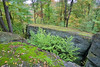
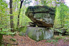
A huge piece of rock lies in a balancing state on a stone pedestal in Rock city Park. This stone is located a few kilometers from the town of Olean.
Apparently this boulder is an ancient, perhaps cult or ritual object - resembles the appearance of a typical Seid.
Megalithica.ru
You may be viewing yesterday's version of this page. To see the most up to date information please register for a free account.
")
")
")
")
Do not use the above information on other web sites or publications without permission of the contributor.
Nearby Images from Flickr


The above images may not be of the site on this page, but were taken nearby. They are loaded from Flickr so please click on them for image credits.
Click here to see more info for this site
Nearby sites
Click here to view sites on an interactive map of the areaKey: Red: member's photo, Blue: 3rd party photo, Yellow: other image, Green: no photo - please go there and take one, Grey: site destroyed
Download sites to:
KML (Google Earth)
GPX (GPS waypoints)
CSV (Garmin/Navman)
CSV (Excel)
To unlock full downloads you need to sign up as a Contributory Member. Otherwise downloads are limited to 50 sites.
Turn off the page maps and other distractions
Nearby sites listing. In the following links * = Image available
135.5km SW 236° Indian God Rock Rock Art
159.2km E 90° Spanish Hill* Artificial Mound
216.4km SW 218° McKees Rocks Mound* Artificial Mound
230.9km SW 223° Artificial Mound in Great Lakes Midwest* Artificial Mound
230.9km SE 134° Boxcar Rocks* Natural Stone / Erratic / Other Natural Feature
244.8km N 6° Serpent Mound, Keene* Misc. Earthwork
256.1km SW 222° Meadowcroft Rockshelter* Cave or Rock Shelter
269.7km SE 139° Bring Rocks Manheim* Modern Stone Circle etc
273.5km N 0° Jacob's Island Mound Barrow Cemetery
276.7km SW 223° Hodgen's Cemetery Mound* Artificial Mound
281.9km WSW 244° Nobles Pond* Ancient Village or Settlement
284.2km ESE 111° Scotrun* Round Cairn
287.5km WSW 251° Paleo Crossing Ancient Village or Settlement
288.7km N 7° Petroglyphs Provincial Park (Ontario)* Rock Art
290.4km SE 125° Oley Hills* Cairn
295.6km ESE 122° Museum of Indian Culture* Museum
295.8km SE 142° Safe Harbor Petroglyphs* Rock Art
298.0km ESE 116° Jacobsburg Stone Skull* Rock Art
298.5km ESE 113° Columcille Megalith Park* Modern Stone Circle etc
300.0km ESE 123° Vera Cruz Quarry Pits* Ancient Mine, Quarry or other Industry
301.4km SW 220° Grave Creek Mound* Artificial Mound
310.1km WNW 297° Davidson Ancient Village or Settlement
310.2km ESE 117° Lenape Nation Cultural Center and Trading Post Museum
314.5km NE 41° Perch Lake mounds* Artificial Mound
318.3km N 350° Lewiston Mound State Park* Artificial Mound
View more nearby sites and additional images


 We would like to know more about this location. Please feel free to add a brief description and any relevant information in your own language.
 Wir möchten mehr über diese Stätte erfahren. Bitte zögern Sie nicht, eine kurze Beschreibung und relevante Informationen in Deutsch hinzuzufügen.
 Nous aimerions en savoir encore un peu sur les lieux. S'il vous plaît n'hesitez pas à ajouter une courte description et tous les renseignements pertinents dans votre propre langue.
 Quisieramos informarnos un poco más de las lugares. No dude en añadir una breve descripción y otros datos relevantes en su propio idioma.