<< Our Photo Pages >> Scotrun - Round Cairn in United States in Mid Atlantic
Submitted by aluta on Tuesday, 24 October 2006 Page Views: 11746
Neolithic and Bronze AgeSite Name: ScotrunCountry: United States
NOTE: This site is 69.15 km away from the location you searched for.
Region: Mid Atlantic Type: Round Cairn
Nearest Town: Scot Run
Latitude: 41.052000N Longitude: 75.315W
Condition:
| 5 | Perfect |
| 4 | Almost Perfect |
| 3 | Reasonable but with some damage |
| 2 | Ruined but still recognisable as an ancient site |
| 1 | Pretty much destroyed, possibly visible as crop marks |
| 0 | No data. |
| -1 | Completely destroyed |
| 5 | Superb |
| 4 | Good |
| 3 | Ordinary |
| 2 | Not Good |
| 1 | Awful |
| 0 | No data. |
| 5 | Can be driven to, probably with disabled access |
| 4 | Short walk on a footpath |
| 3 | Requiring a bit more of a walk |
| 2 | A long walk |
| 1 | In the middle of nowhere, a nightmare to find |
| 0 | No data. |
| 5 | co-ordinates taken by GPS or official recorded co-ordinates |
| 4 | co-ordinates scaled from a detailed map |
| 3 | co-ordinates scaled from a bad map |
| 2 | co-ordinates of the nearest village |
| 1 | co-ordinates of the nearest town |
| 0 | no data |
Internal Links:
External Links:
I have visited· I would like to visit
aluta has visited here
")
Once a fine example of a wall-and-cairn site, this site is now said to be mostly destroyed. It was considered by those who knew it to be one of the most significant sites in Pennsylvania, because of the variety of features to be found in close proximity to one another: parallel walls across the hill with other parallel walls running up the hill, carefully-shaped rockpiles formed on boulders in different ways, groups of stones said to form animal effigies, a chamber set into a wall, and a rare standing stone.
When Great Wolf Lodge built on the site, they destroyed nearly all of it after promising to preserve it. Ironically, they use totem poles--symbols of people indigenous to the northwestern United States--as part of their image.
This was one of the sites visited by the joint group of indigenous descendants, amateur stonework investigators, and archaeologists during the Delaware Water Gap Conference of several years ago.
You may be viewing yesterday's version of this page. To see the most up to date information please register for a free account.
Do not use the above information on other web sites or publications without permission of the contributor.
Nearby Images from Flickr


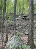
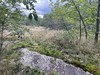
The above images may not be of the site on this page, but were taken nearby. They are loaded from Flickr so please click on them for image credits.
Click here to see more info for this site
Nearby sites
Click here to view sites on an interactive map of the areaKey: Red: member's photo, Blue: 3rd party photo, Yellow: other image, Green: no photo - please go there and take one, Grey: site destroyed
Download sites to:
KML (Google Earth)
GPX (GPS waypoints)
CSV (Garmin/Navman)
CSV (Excel)
To unlock full downloads you need to sign up as a Contributory Member. Otherwise downloads are limited to 50 sites.
Turn off the page maps and other distractions
Nearby sites listing. In the following links * = Image available
16.8km SE 146° Columcille Megalith Park* Modern Stone Circle etc
29.4km S 178° Jacobsburg Stone Skull* Rock Art
41.1km SSE 167° Lenape Nation Cultural Center and Trading Post Museum
46.4km ESE 118° Hackettstown Ceremonial Stone Landscape* Cairn
56.7km SSW 197° Museum of Indian Culture* Museum
56.8km SSE 164° Ringing Rocks* Natural Stone / Erratic / Other Natural Feature
62.4km SSW 195° Vera Cruz Quarry Pits* Ancient Mine, Quarry or other Industry
62.5km SSE 150° Quakertown Bedrock Mortar Museum
68.2km SSW 205° Oley Hills* Cairn
78.5km E 98° Tripod Rock* Natural Stone / Erratic / Other Natural Feature
84.0km S 169° Bucks County PA Sacred Ceremonial Stone Landscape* Standing Stones
116.0km ESE 109° National Museum of the American Indian* Museum
116.2km WSW 242° Boxcar Rocks* Natural Stone / Erratic / Other Natural Feature
116.7km ESE 105° American Museum of Natural History (New York)* Museum
117.4km ESE 105° New York Cleopatra's Needle* Standing Stone (Menhir)
117.6km ESE 104° Metropolitan Museum of Art* Museum
120.0km ESE 105° Noguchi Humming Stone (Summstein) Modern Stone Circle etc
123.0km S 175° Penn Museum* Museum
123.6km E 87° Glacial Erratic, Rockefeller State Park Preserve* Natural Stone / Erratic / Other Natural Feature
133.4km SW 223° Bring Rocks Manheim* Modern Stone Circle etc
136.9km ENE 69° Forest ct Stones* Modern Stone Circle etc
139.7km ENE 68° Stormville Structure* Modern Stone Circle etc
146.2km ENE 69° Ludingtonville stones* Modern Stone Circle etc
146.9km NW 316° Spanish Hill* Artificial Mound
149.2km ENE 77° North Salem Dolmen* Natural Stone / Erratic / Other Natural Feature
View more nearby sites and additional images


 We would like to know more about this location. Please feel free to add a brief description and any relevant information in your own language.
 Wir möchten mehr über diese Stätte erfahren. Bitte zögern Sie nicht, eine kurze Beschreibung und relevante Informationen in Deutsch hinzuzufügen.
 Nous aimerions en savoir encore un peu sur les lieux. S'il vous plaît n'hesitez pas à ajouter une courte description et tous les renseignements pertinents dans votre propre langue.
 Quisieramos informarnos un poco más de las lugares. No dude en añadir una breve descripción y otros datos relevantes en su propio idioma.