

<< Our Photo Pages >> Montalegre - Modern Stone Circle etc in Portugal in Vila Real
Submitted by Alta-Falisa on Tuesday, 21 July 2015 Page Views: 1506
Modern SitesSite Name: Montalegre Alternative Name: Modern AntaCountry: Portugal
NOTE: This site is 2.264 km away from the location you searched for.
Distrito: Vila Real Type: Modern Stone Circle etc
Nearest Town: Montalegre
Latitude: 41.835950N Longitude: 7.77065W
Condition:
| 5 | Perfect |
| 4 | Almost Perfect |
| 3 | Reasonable but with some damage |
| 2 | Ruined but still recognisable as an ancient site |
| 1 | Pretty much destroyed, possibly visible as crop marks |
| 0 | No data. |
| -1 | Completely destroyed |
| 5 | Superb |
| 4 | Good |
| 3 | Ordinary |
| 2 | Not Good |
| 1 | Awful |
| 0 | No data. |
| 5 | Can be driven to, probably with disabled access |
| 4 | Short walk on a footpath |
| 3 | Requiring a bit more of a walk |
| 2 | A long walk |
| 1 | In the middle of nowhere, a nightmare to find |
| 0 | No data. |
| 5 | co-ordinates taken by GPS or official recorded co-ordinates |
| 4 | co-ordinates scaled from a detailed map |
| 3 | co-ordinates scaled from a bad map |
| 2 | co-ordinates of the nearest village |
| 1 | co-ordinates of the nearest town |
| 0 | no data |
Internal Links:
External Links:
")
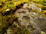
A modern trilithon erected on a round-about along the main road leaving Montalegre towards the East.
To stress the importance of the neolithic architectural heritage, this modern construction can be compared to the Anta da Rotunda de Caria and even to the Rotunda das Antas.
You may be viewing yesterday's version of this page. To see the most up to date information please register for a free account.
Do not use the above information on other web sites or publications without permission of the contributor.
Nearby Images from Flickr

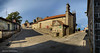


The above images may not be of the site on this page, but were taken nearby. They are loaded from Flickr so please click on them for image credits.
Click here to see more info for this site
Nearby sites
Click here to view sites on an interactive map of the areaKey: Red: member's photo, Blue: 3rd party photo, Yellow: other image, Green: no photo - please go there and take one, Grey: site destroyed
Download sites to:
KML (Google Earth)
GPX (GPS waypoints)
CSV (Garmin/Navman)
CSV (Excel)
To unlock full downloads you need to sign up as a Contributory Member. Otherwise downloads are limited to 50 sites.
Turn off the page maps and other distractions
Nearby sites listing. In the following links * = Image available
1.6km WNW 293° Sepulturas antropomórficas de Santo Adrião* Rock Cut Tomb
2.4km SW 235° Mamoas da Veiga Round Barrow(s)
4.6km WSW 258° Sepulturas antropomórficas de Donões* Rock Cut Tomb
9.8km ESE 114° Castro do Pedrário Castro or Chafurdão
10.5km NE 53° Castro da Xironda Castro or Chafurdão
11.3km SW 223° Castro de São Romão Castro or Chafurdão
15.7km ENE 66° Castro de San Millao Castro or Chafurdão
15.7km NW 309° Necrópole de Outeiro de Cavaladre* Burial Chamber or Dolmen
15.9km NE 48° Castro de Saceda* Castro or Chafurdão
16.7km SSE 161° Castro de Carvalhelhos Castro or Chafurdão
17.2km WNW 302° Casola do Foxo* Burial Chamber or Dolmen
17.5km NW 306° Casiña da Moura* Burial Chamber or Dolmen
18.6km SSE 147° Castro de Cabeço Castro or Chafurdão
20.0km S 172° Castro de Lesenho Castro or Chafurdão
20.4km NE 51° Petróglifos Penedo do Muro Rock Art
21.2km S 176° Castro Outeiro Lesenho* Castro or Chafurdão
22.4km NE 43° Castro de Lucenza Castro or Chafurdão
23.2km NW 311° Aquis Querquennis Campamento Romano* Ancient Village or Settlement
23.3km NW 310° Pedrafita en Aquis Querquernis Standing Stone (Menhir)
23.8km SSW 195° Castro da Giestosa Castro or Chafurdão
24.8km ENE 68° Petróglifos das Chás Rock Art
25.3km N 9° Castro da Cidade Castro or Chafurdão
27.0km ESE 113° Museo da Região Flaviense* Museum
28.0km W 275° Aquis Originis Ancient Village or Settlement
30.0km W 265° Portela do Homem* Modern Stone Circle etc
View more nearby sites and additional images


 We would like to know more about this location. Please feel free to add a brief description and any relevant information in your own language.
 Wir möchten mehr über diese Stätte erfahren. Bitte zögern Sie nicht, eine kurze Beschreibung und relevante Informationen in Deutsch hinzuzufügen.
 Nous aimerions en savoir encore un peu sur les lieux. S'il vous plaît n'hesitez pas à ajouter une courte description et tous les renseignements pertinents dans votre propre langue.
 Quisieramos informarnos un poco más de las lugares. No dude en añadir una breve descripción y otros datos relevantes en su propio idioma.