

<< Our Photo Pages >> Areita Dolmen - Burial Chamber or Dolmen in Portugal in Viseu
Submitted by AlexHunger on Sunday, 09 April 2006 Page Views: 8081
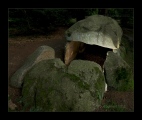
Neolithic and Bronze AgeSite Name: Areita Dolmen Alternative Name: Dólmen de AreitaCountry: Portugal
NOTE: This site is 8.876 km away from the location you searched for.
Distrito: Viseu Type: Burial Chamber or Dolmen
Nearest Town: Penedono Nearest Village: Paredes Da Beira
Latitude: 41.046480N Longitude: 7.4714W
Condition:
| 5 | Perfect |
| 4 | Almost Perfect |
| 3 | Reasonable but with some damage |
| 2 | Ruined but still recognisable as an ancient site |
| 1 | Pretty much destroyed, possibly visible as crop marks |
| 0 | No data. |
| -1 | Completely destroyed |
| 5 | Superb |
| 4 | Good |
| 3 | Ordinary |
| 2 | Not Good |
| 1 | Awful |
| 0 | No data. |
| 5 | Can be driven to, probably with disabled access |
| 4 | Short walk on a footpath |
| 3 | Requiring a bit more of a walk |
| 2 | A long walk |
| 1 | In the middle of nowhere, a nightmare to find |
| 0 | No data. |
| 5 | co-ordinates taken by GPS or official recorded co-ordinates |
| 4 | co-ordinates scaled from a detailed map |
| 3 | co-ordinates scaled from a bad map |
| 2 | co-ordinates of the nearest village |
| 1 | co-ordinates of the nearest town |
| 0 | no data |
Internal Links:
External Links:
I have visited· I would like to visit
rrmoser would like to visit
DrewParsons Magalhaes have visited here
")
Large Allee Couverte on the side of a small hill.
You may be viewing yesterday's version of this page. To see the most up to date information please register for a free account.
")
")
")
")
")
")
")
")
")
")
")
")
")
")
")
Do not use the above information on other web sites or publications without permission of the contributor.
Click here to see more info for this site
Nearby sites
Click here to view sites on an interactive map of the areaKey: Red: member's photo, Blue: 3rd party photo, Yellow: other image, Green: no photo - please go there and take one, Grey: site destroyed
Download sites to:
KML (Google Earth)
GPX (GPS waypoints)
CSV (Garmin/Navman)
CSV (Excel)
To unlock full downloads you need to sign up as a Contributory Member. Otherwise downloads are limited to 50 sites.
Turn off the page maps and other distractions
Nearby sites listing. In the following links * = Image available
3.1km ESE 113° Anta do Turgal* Burial Chamber or Dolmen
3.6km SE 135° Dolmen do Carvalhal* Burial Chamber or Dolmen
3.6km SE 136° Monte Penedono Dolmen* Burial Chamber or Dolmen
4.0km SE 146° Dólmen do Sangrino* Burial Chamber or Dolmen
4.0km SE 140° Dólmens de Lapinhas* Burial Chamber or Dolmen
4.0km SSE 146° Sangrino - Rock outcrop* Rock Outcrop
4.3km SE 132° Sepulturas antropomórficas da Vale de Perdieiros* Rock Cut Tomb
4.8km ESE 118° Sepultura antropomórfica de Cômbaros Rock Cut Tomb
5.0km ESE 122° Sepulturas antropomórficas de Fonte Fria Rock Cut Tomb
10.5km SE 141° Menir de Penedono* Standing Stone (Menhir)
10.9km WNW 282° Citânia da Longa Castro or Chafurdão
13.4km SSE 149° Rotunda das Antas* Modern Stone Circle etc
14.3km WSW 242° Parque de Lazer* Modern Stone Circle etc
14.7km SSE 148° Sepulturas antropomórficas de Antas* Rock Cut Tomb
15.8km SSE 154° Menir do Vale de Maria Pais* Standing Stone (Menhir)
15.9km SSE 154° Sepulturas antropomórficas do Vale de Maria Pais* Rock Cut Tomb
16.0km SE 140° Lameira da Cima 2* Burial Chamber or Dolmen
16.0km SE 140° Lameira de Cima 1* Burial Chamber or Dolmen
19.2km E 83° Estação Arqueológica do Prazo* Ancient Village or Settlement
19.3km E 83° Prazo Menhir* Standing Stone (Menhir)
20.5km SW 235° Estátua-Menir da Nave Standing Stone (Menhir)
20.6km WSW 238° Orca do Bebedouro 1 Burial Chamber or Dolmen
21.0km WSW 239° Orca da Fonte do Rato Burial Chamber or Dolmen
21.0km WSW 237° Orca Grande Burial Chamber or Dolmen
21.2km WSW 238° Orca de Seixas Passage Grave
View more nearby sites and additional images


 We would like to know more about this location. Please feel free to add a brief description and any relevant information in your own language.
 Wir möchten mehr über diese Stätte erfahren. Bitte zögern Sie nicht, eine kurze Beschreibung und relevante Informationen in Deutsch hinzuzufügen.
 Nous aimerions en savoir encore un peu sur les lieux. S'il vous plaît n'hesitez pas à ajouter une courte description et tous les renseignements pertinents dans votre propre langue.
 Quisieramos informarnos un poco más de las lugares. No dude en añadir una breve descripción y otros datos relevantes en su propio idioma.