<< Text Pages >> Carra Bhroin (Lochboisdale) - Standing Stone (Menhir) in Scotland in South Uist
Submitted by Anne T on Monday, 22 May 2017 Page Views: 1248
Neolithic and Bronze AgeSite Name: Carra Bhroin (Lochboisdale) Alternative Name: Carragh Broin; Stone of SorrowCountry: Scotland
NOTE: This site is 1.212 km away from the location you searched for.
County: South Uist Type: Standing Stone (Menhir)
Nearest Village: Lochboisdale
Map Ref: NF81172248
Latitude: 57.181883N Longitude: 7.278737W
Condition:
| 5 | Perfect |
| 4 | Almost Perfect |
| 3 | Reasonable but with some damage |
| 2 | Ruined but still recognisable as an ancient site |
| 1 | Pretty much destroyed, possibly visible as crop marks |
| 0 | No data. |
| -1 | Completely destroyed |
| 5 | Superb |
| 4 | Good |
| 3 | Ordinary |
| 2 | Not Good |
| 1 | Awful |
| 0 | No data. |
| 5 | Can be driven to, probably with disabled access |
| 4 | Short walk on a footpath |
| 3 | Requiring a bit more of a walk |
| 2 | A long walk |
| 1 | In the middle of nowhere, a nightmare to find |
| 0 | No data. |
| 5 | co-ordinates taken by GPS or official recorded co-ordinates |
| 4 | co-ordinates scaled from a detailed map |
| 3 | co-ordinates scaled from a bad map |
| 2 | co-ordinates of the nearest village |
| 1 | co-ordinates of the nearest town |
| 0 | no data |
Be the first person to rate this site - see the 'Contribute!' box in the right hand menu.
Internal Links:
External Links:
Standing Stone (Menhir) in South Uist
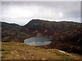
The Carra Bhroin or Carragh Broin standing stone is recorded on Canmore ID 10138. Canmore tell us in their original 1928 entry that the stone is " is situated 20 yards from the shore at the SE corner of Loch Nan Arm, on the left bank of a rivulet running into the loch. It is 2ft high, 2ft 7ins broad and 1ft 4ins thick. It is so named because a man, wounded in a nearby battle, lent his body against it." By 1965, they record "with the loch at its present level the stone is only about 10m from the shore." In 1965, it was reported that the stone had been destroyed in 'fencing operations' byt in April 1967, it was reported that there was a stone still in this position!
The Northern Antiquarian (TNA) also have a page for this stone - see their entry for Carra Bhroin, Lochboisdale, South Uist, which features a brief archaeology and history and folklore.
Note: Have you visited this site? Do you have any photographs or further information you can add?
You may be viewing yesterday's version of this page. To see the most up to date information please register for a free account.
Do not use the above information on other web sites or publications without permission of the contributor.
Nearby Images from Geograph Britain and Ireland:
©2017(licence)
©2009(licence)
©2016(licence)
©2009(licence)
©2010(licence)
The above images may not be of the site on this page, they are loaded from Geograph.
Please Submit an Image of this site or go out and take one for us!
Click here to see more info for this site
Nearby sites
Key: Red: member's photo, Blue: 3rd party photo, Yellow: other image, Green: no photo - please go there and take one, Grey: site destroyed
Download sites to:
KML (Google Earth)
GPX (GPS waypoints)
CSV (Garmin/Navman)
CSV (Excel)
To unlock full downloads you need to sign up as a Contributory Member. Otherwise downloads are limited to 50 sites.
Turn off the page maps and other distractions
Nearby sites listing. In the following links * = Image available
6.6km WNW 297° Barp Reineval* Chambered Cairn (NF7549425972)
7.3km NW 305° Bornais Ancient Village or Settlement (NF7551527184)
7.4km WSW 238° Dun Na Killie Stone Fort or Dun (NF74611905)
7.7km WSW 238° Dun An Duichal Stone Fort or Dun (NF74311885)
8.0km W 262° Cladh Hallan* Ancient Village or Settlement (NF7313821977)
8.1km WSW 250° Kilpheder Wheelhouse* Ancient Village or Settlement (NF733203)
8.2km WNW 301° Dun in Loch na Muilne* Stone Fort or Dun (NF7445327237)
9.3km SSW 214° The Witches Grave* Chambered Cairn (NF7539715098)
10.4km WNW 302° Ru Ardvule* Stone Row / Alignment (NF72732860)
10.4km SW 215° Pollachar* Standing Stone (Menhir) (NF745144)
10.5km NNW 332° An Carra * Standing Stone (Menhir) (NF77033211)
12.2km WNW 303° Dun Vulan Broch* Broch or Nuraghe (NF71412981)
13.6km NW 321° Crois Chnoca Breaca* Standing Stone (Menhir) (NF73403366)
18.2km SSW 211° Tobar Bharra* Holy Well or Sacred Spring (NF7061607538)
18.4km SSW 212° Kilbar (Isle of Barra)* Ancient Cross (NF703076)
18.7km NNW 339° Drimore, A' Cheardach Bheag* Ancient Village or Settlement (NF757404)
19.5km NNW 339° Drimore, A' Cheardach Mhor* Ancient Village or Settlement (NF75704129)
22.9km N 355° Sig More* Chambered Cairn (NF8098345483)
24.0km SSW 213° Dun Cuier Broch or Nuraghe (NF6642003406)
24.8km SSW 210° Dun Bharpa* Chambered Cairn (NF6719001910)
25.0km SW 214° Allasdale Dunes Cairn (NF65610283)
25.2km SSW 208° Balnacraig Cairn Barra * Chambered Cairn (NF67620120)
26.3km SSW 213° Borve Standing Stones* Standing Stones (NF65270144)
26.4km N 353° Dun Fhearchair Stone Fort or Dun (NF80104890)
26.4km SSW 203° Brevig* Standing Stones (NL689990)
View more nearby sites and additional images


 We would like to know more about this location. Please feel free to add a brief description and any relevant information in your own language.
 Wir möchten mehr über diese Stätte erfahren. Bitte zögern Sie nicht, eine kurze Beschreibung und relevante Informationen in Deutsch hinzuzufügen.
 Nous aimerions en savoir encore un peu sur les lieux. S'il vous plaît n'hesitez pas à ajouter une courte description et tous les renseignements pertinents dans votre propre langue.
 Quisieramos informarnos un poco más de las lugares. No dude en añadir una breve descripción y otros datos relevantes en su propio idioma.