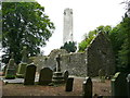
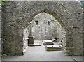
<< Our Photo Pages >> Kilree Monastery - Ancient Cross in Ireland (Republic of) in Co. Kilkenny
Submitted by jansold on Sunday, 28 September 2014 Page Views: 2017
Early Medieval (Dark Age)Site Name: Kilree MonasteryCountry: Ireland (Republic of)
NOTE: This site is 2.021 km away from the location you searched for.
County: Co. Kilkenny Type: Ancient Cross
Nearest Town: Kilkenny
Latitude: 52.518317N Longitude: 7.269014W
Condition:
| 5 | Perfect |
| 4 | Almost Perfect |
| 3 | Reasonable but with some damage |
| 2 | Ruined but still recognisable as an ancient site |
| 1 | Pretty much destroyed, possibly visible as crop marks |
| 0 | No data. |
| -1 | Completely destroyed |
| 5 | Superb |
| 4 | Good |
| 3 | Ordinary |
| 2 | Not Good |
| 1 | Awful |
| 0 | No data. |
| 5 | Can be driven to, probably with disabled access |
| 4 | Short walk on a footpath |
| 3 | Requiring a bit more of a walk |
| 2 | A long walk |
| 1 | In the middle of nowhere, a nightmare to find |
| 0 | No data. |
| 5 | co-ordinates taken by GPS or official recorded co-ordinates |
| 4 | co-ordinates scaled from a detailed map |
| 3 | co-ordinates scaled from a bad map |
| 2 | co-ordinates of the nearest village |
| 1 | co-ordinates of the nearest town |
| 0 | no data |
Internal Links:
External Links:
I have visited· I would like to visit
Jansold visited on 5th Sep 2014 - their rating: Cond: 2 Amb: 4 Access: 4
")
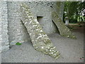
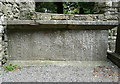
The founding date of the monastery is unknown, but the high cross is believed to be 9th century. The cross is weathered sandstone, standing 2.75m and decorated with bosses and other geometrical motifs.
On the west face there is a panel probably depicting the adoration of the Magi. The cross is topped by a tenon joint, so possibly there was originally a capstone.
You may be viewing yesterday's version of this page. To see the most up to date information please register for a free account.
Do not use the above information on other web sites or publications without permission of the contributor.
Nearby Images from Geograph Britain and Ireland:
©2014(licence)
©2014(licence)
©2014(licence)
©2014(licence)
©2014(licence)
The above images may not be of the site on this page, they are loaded from Geograph.
Please Submit an Image of this site or go out and take one for us!
Click here to see more info for this site
Nearby sites
Click here to view sites on an interactive map of the areaKey: Red: member's photo, Blue: 3rd party photo, Yellow: other image, Green: no photo - please go there and take one, Grey: site destroyed
Download sites to:
KML (Google Earth)
GPX (GPS waypoints)
CSV (Garmin/Navman)
CSV (Excel)
To unlock full downloads you need to sign up as a Contributory Member. Otherwise downloads are limited to 50 sites.
Turn off the page maps and other distractions
Nearby sites listing. In the following links * = Image available
7.1km E 95° St Nicholas's Grave (Newtown Jerpoint) Early Christian Sculptured Stone (S56794042)
12.8km S 178° Kilmogue portal tomb* Portal Tomb
12.8km S 178° Kilmogue standing stone Standing Stone (Menhir)
12.9km WSW 248° Killamery High Cross Ancient Cross (S377361)
13.1km SW 223° Knockroe* Passage Grave (S40863126)
14.3km SSW 208° Baunfree* Passage Grave
14.5km SW 216° The Cross of Ages (Kilclispeen)* Ancient Cross (S413291)
17.2km SE 141° Three Friars* Stone Row / Alignment
19.3km E 93° Brandon Hill Stone Circle (S690400)
23.2km E 98° St. Mullin's Motte and Bailey* Ancient Village or Settlement
24.3km SE 125° Glencloghlea* Portal Tomb (S698273)
24.3km SSW 201° Ballyquin* Portal Tomb (S411182)
29.9km SE 135° Whitechurch Standing Stone Standing Stone (Menhir)
30.6km SE 137° Whitechurch Stone Circle (S710190)
30.8km SE 136° Whitechurch Stone Row / Alignment
33.5km ESE 111° Robinstown Great* Stone Circle (S8104629049)
34.4km WNW 299° Two-Mile Borris Ancient Village or Settlement (S19245729)
35.0km S 173° Gaulstown Portal Dolmen* Burial Chamber or Dolmen
35.3km SSE 168° Knockeen Portal Tomb* Portal Tomb (S575065)
36.4km ESE 118° Carrickbyrne Stone Circle (S820240)
37.1km WSW 241° St Patrick's Holy Well (Clonmel) Holy Well or Sacred Spring (S173227)
37.9km S 181° Ballinageeragh* Portal Tomb
38.3km S 176° Matthewstown* Passage Grave (S528028)
38.5km ESE 121° Newbawn Portal Tomb
38.5km SW 221° Tooreen W Stone Row / Alignment (S245117)
View more nearby sites and additional images


 We would like to know more about this location. Please feel free to add a brief description and any relevant information in your own language.
 Wir möchten mehr über diese Stätte erfahren. Bitte zögern Sie nicht, eine kurze Beschreibung und relevante Informationen in Deutsch hinzuzufügen.
 Nous aimerions en savoir encore un peu sur les lieux. S'il vous plaît n'hesitez pas à ajouter une courte description et tous les renseignements pertinents dans votre propre langue.
 Quisieramos informarnos un poco más de las lugares. No dude en añadir una breve descripción y otros datos relevantes en su propio idioma.