<< Text Pages >> Rock of Dunamase - Hillfort in Ireland (Republic of) in Co. Laois
Submitted by Sunny100 on Monday, 08 November 2010 Page Views: 5058
Iron Age and Later PrehistorySite Name: Rock of Dunamase Alternative Name: Fort of Dun MascCountry: Ireland (Republic of)
NOTE: This site is 1.873 km away from the location you searched for.
County: Co. Laois Type: Hillfort
Nearest Town: Portlaoise Nearest Village: Ballycarrol
Map Ref: S530982
Latitude: 53.032162N Longitude: 7.210741W
Condition:
| 5 | Perfect |
| 4 | Almost Perfect |
| 3 | Reasonable but with some damage |
| 2 | Ruined but still recognisable as an ancient site |
| 1 | Pretty much destroyed, possibly visible as crop marks |
| 0 | No data. |
| -1 | Completely destroyed |
| 5 | Superb |
| 4 | Good |
| 3 | Ordinary |
| 2 | Not Good |
| 1 | Awful |
| 0 | No data. |
| 5 | Can be driven to, probably with disabled access |
| 4 | Short walk on a footpath |
| 3 | Requiring a bit more of a walk |
| 2 | A long walk |
| 1 | In the middle of nowhere, a nightmare to find |
| 0 | No data. |
| 5 | co-ordinates taken by GPS or official recorded co-ordinates |
| 4 | co-ordinates scaled from a detailed map |
| 3 | co-ordinates scaled from a bad map |
| 2 | co-ordinates of the nearest village |
| 1 | co-ordinates of the nearest town |
| 0 | no data |
Internal Links:
External Links:
I have visited· I would like to visit
lucy78green would like to visit
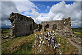
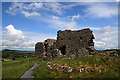
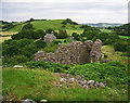
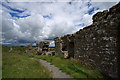
The Rock of Dunamase (Dun Masc) is a Dark-Age hillfort that stands 150 feet (46 metres) above the flat Laois countryside near the N80 road between Portlaoise and Stradbally. There was some occupation in the time of St Patrick but it was in the 9th century CE that a Dark-Age fort was built on the top of the hill. Later, in the 12th century a Norman castle was built in it's place.
In the early 5th century CE Dunamase and the surrounding land was ruled by the chieftain Laois Ceannmor (he gave his name to the county). It's possible that St Patrick also visited the rock upon his arrival in Ireland about 432 CE. In the 9th century CE a fort or dun was built on it's summit by a chieftain called Masc or Masg. Nothing much remains of that fort. A Norman castle was built on the crown of the hill in the 12th century; the ruins there today are from a 15th century re-build.
In the 1990s the site was excavated and due to this the true dating of the site was established. It was also found that the fort had been attacked and destroyed by Vikings between 843-5. It is said to be one of the most historic sites in Ireland.
You may be viewing yesterday's version of this page. To see the most up to date information please register for a free account.
Do not use the above information on other web sites or publications without permission of the contributor.
Nearby Images from Geograph Britain and Ireland:
©2011(licence)
©2011(licence)

©2020(licence)
©2020(licence)
©2011(licence)
The above images may not be of the site on this page, they are loaded from Geograph.
Please Submit an Image of this site or go out and take one for us!
Click here to see more info for this site
Nearby sites
Click here to view sites on an interactive map of the areaKey: Red: member's photo, Blue: 3rd party photo, Yellow: other image, Green: no photo - please go there and take one, Grey: site destroyed
Download sites to:
KML (Google Earth)
GPX (GPS waypoints)
CSV (Garmin/Navman)
CSV (Excel)
To unlock full downloads you need to sign up as a Contributory Member. Otherwise downloads are limited to 50 sites.
Turn off the page maps and other distractions
Nearby sites listing. In the following links * = Image available
2.8km NNW 344° The Heath (Laois)* Barrow Cemetery
8.2km SE 126° The Ass's Manger* Cist (S5967393415)
10.0km SE 137° Druids Altar (Co. Laois) Stone Circle (S600910)
12.2km SSE 159° Druids Altar (Monamanry) Ring Cairn
15.9km SSE 167° Slatt Lower Stone Circle (S568827)
23.6km ENE 58° St Brigid's Holy Well Kildare* Holy Well or Sacred Spring (N73061080)
26.4km ESE 103° Moone High Cross* Ancient Cross (S7891192693)
28.6km ESE 118° Castledermot High Crosses* Ancient Cross
30.2km E 80° Kilgowan* Standing Stone (Menhir)
30.4km E 85° Brewel Hill Stone Circle (N833013)
30.5km ENE 72° Knockaulin Timber Circle (N820078)
30.9km SE 134° Browne’s Hill* Portal Tomb (S7538476873)
31.2km ENE 74° Old Kilcullen High Cross Ancient Cross
33.9km E 88° Tournant Stone Circle (N870000)
36.5km WSW 247° Timoney* Stone Circle (S193838)
36.5km ESE 105° Baltinglass* Passage Grave (S8855289249)
38.7km E 97° Castleruddery* Stone Circle (S9159394210)
39.6km E 97° Castleruddery Stone Row / Alignment (S925937)
39.9km ESE 104° Gates Of Heaven Burial Chamber or Dolmen
40.2km E 83° Athgreany* Stone Circle (N930032)
40.5km ENE 78° Whiteleas Stone Circle
40.9km ENE 77° Broadleas* Stone Circle (N9292507609)
41.0km SE 131° Ardristan* Standing Stone (Menhir) (S8413871337)
41.3km ESE 103° Boleycarrigeen* Stone Circle
42.1km ENE 65° Craddockstown West* Standing Stone (Menhir) (N9116416282)
View more nearby sites and additional images


 We would like to know more about this location. Please feel free to add a brief description and any relevant information in your own language.
 Wir möchten mehr über diese Stätte erfahren. Bitte zögern Sie nicht, eine kurze Beschreibung und relevante Informationen in Deutsch hinzuzufügen.
 Nous aimerions en savoir encore un peu sur les lieux. S'il vous plaît n'hesitez pas à ajouter une courte description et tous les renseignements pertinents dans votre propre langue.
 Quisieramos informarnos un poco más de las lugares. No dude en añadir una breve descripción y otros datos relevantes en su propio idioma.