 with our Megalithic Portal iPhone app")


<< Text Pages >> El Fuerte de Samaipata - Pyramid / Mastaba in Bolivia
Submitted by bat400 on Sunday, 30 November 2014 Page Views: 2484
Multi-periodSite Name: El Fuerte de Samaipata Alternative Name: Fort Samaipata,Country: Bolivia Type: Pyramid / Mastaba
Nearest Town: Santa Cruz Nearest Village: Samaipata
Latitude: 18.179S Longitude: 63.8195W
Condition:
| 5 | Perfect |
| 4 | Almost Perfect |
| 3 | Reasonable but with some damage |
| 2 | Ruined but still recognisable as an ancient site |
| 1 | Pretty much destroyed, possibly visible as crop marks |
| 0 | No data. |
| -1 | Completely destroyed |
| 5 | Superb |
| 4 | Good |
| 3 | Ordinary |
| 2 | Not Good |
| 1 | Awful |
| 0 | No data. |
| 5 | Can be driven to, probably with disabled access |
| 4 | Short walk on a footpath |
| 3 | Requiring a bit more of a walk |
| 2 | A long walk |
| 1 | In the middle of nowhere, a nightmare to find |
| 0 | No data. |
| 5 | co-ordinates taken by GPS or official recorded co-ordinates |
| 4 | co-ordinates scaled from a detailed map |
| 3 | co-ordinates scaled from a bad map |
| 2 | co-ordinates of the nearest village |
| 1 | co-ordinates of the nearest town |
| 0 | no data |
Internal Links:
External Links:
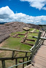
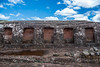
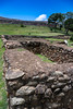
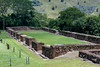
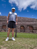
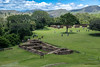
Pyramid / Mastaba in Santa Cruz Department.
Built by the Chané people starting in around 300AD, the original site appears to be ceremonial or religious in nature, with parallel lines carved into an exposed bedrock. These may have an astronomical association.
Later an Incan town was built on the same site in the 1400's, with a later Spanish town site also occupying the site.
A UNESCO World Heritage Site.
You may be viewing yesterday's version of this page. To see the most up to date information please register for a free account.
Do not use the above information on other web sites or publications without permission of the contributor.
Nearby Images from Flickr
The above images may not be of the site on this page, but were taken nearby. They are loaded from Flickr so please click on them for image credits.
Click here to see more info for this site
Nearby sites
Click here to view sites on an interactive map of the areaKey: Red: member's photo, Blue: 3rd party photo, Yellow: other image, Green: no photo - please go there and take one, Grey: site destroyed
Download sites to:
KML (Google Earth)
GPX (GPS waypoints)
CSV (Garmin/Navman)
CSV (Excel)
To unlock full downloads you need to sign up as a Contributory Member. Otherwise downloads are limited to 50 sites.
Turn off the page maps and other distractions
Nearby sites listing. In the following links * = Image available
16.2km WNW 292° Mairana Circular Pyramid Pyramid / Mastaba
180.0km WSW 237° Sucre Museum of Anthropology Museum
252.5km SW 235° Tarapaya* Natural Stone / Erratic / Other Natural Feature
258.6km SW 231° Cerro Rico* Ancient Mine, Quarry or other Industry
545.7km WNW 289° Tiwanaku - Akapana Pyramid* Pyramid / Mastaba
545.9km WNW 289° Tiwanaku* Ancient Village or Settlement
546.2km WNW 288° Pumapunku* Ancient Temple
564.9km WNW 291° Suriki Island* Ancient Mine, Quarry or other Industry
573.1km SSW 195° Coctaca Ancient Village or Settlement
575.8km N 5° Loma Chacolatalito Artificial Mound
580.1km SSW 196° Pucará de Peñas Blancas Hillfort
598.5km SSW 195° Los Armarillos Ancient Village or Settlement
598.8km SSW 195° Pucará de Yacoraite Hillfort
602.5km WNW 291° Copacabana Ceremonial Center Ancient Temple
604.0km SSW 195° Pucará de Campo Morado Hillfort
608.9km SSW 194° La Huerta Ancient Village or Settlement
611.9km SSW 195° Pucará del Angosto de Perchel Hillfort
614.0km WNW 292° La Fuente del Inca* Holy Well or Sacred Spring
615.8km SSW 195° Pucará de Juella Hillfort
615.8km WNW 286° Cuncaicha Natural Stone / Erratic / Other Natural Feature
623.4km SSW 195° Pucará de Tilcara* Ancient Village or Settlement
627.8km WSW 251° Tarapacá geoglyphs Hill Figure or Geoglyph
641.9km WSW 251° Atacama Giant* Hill Figure or Geoglyph
647.6km WNW 289° Aramu Muru* Sculptured Stone
661.8km W 259° Chiza Geoglyphs* Hill Figure or Geoglyph
View more nearby sites and additional images


 We would like to know more about this location. Please feel free to add a brief description and any relevant information in your own language.
 Wir möchten mehr über diese Stätte erfahren. Bitte zögern Sie nicht, eine kurze Beschreibung und relevante Informationen in Deutsch hinzuzufügen.
 Nous aimerions en savoir encore un peu sur les lieux. S'il vous plaît n'hesitez pas à ajouter une courte description et tous les renseignements pertinents dans votre propre langue.
 Quisieramos informarnos un poco más de las lugares. No dude en añadir una breve descripción y otros datos relevantes en su propio idioma.