

<< Other Photo Pages >> The Three Sisters - Stone Row / Alignment in Ireland (Northern) in Co. Down
Submitted by Anonymous on Tuesday, 01 October 2002 Page Views: 8283
Neolithic and Bronze AgeSite Name: The Three Sisters Alternative Name: Place of the SunCountry: Ireland (Northern)
NOTE: This site is 4.503 km away from the location you searched for.
County: Co. Down Type: Stone Row / Alignment
Discoverer Map Number: D20
Latitude: 54.308124N Longitude: 6.308216W
Condition:
| 5 | Perfect |
| 4 | Almost Perfect |
| 3 | Reasonable but with some damage |
| 2 | Ruined but still recognisable as an ancient site |
| 1 | Pretty much destroyed, possibly visible as crop marks |
| 0 | No data. |
| -1 | Completely destroyed |
| 5 | Superb |
| 4 | Good |
| 3 | Ordinary |
| 2 | Not Good |
| 1 | Awful |
| 0 | No data. |
| 5 | Can be driven to, probably with disabled access |
| 4 | Short walk on a footpath |
| 3 | Requiring a bit more of a walk |
| 2 | A long walk |
| 1 | In the middle of nowhere, a nightmare to find |
| 0 | No data. |
| 5 | co-ordinates taken by GPS or official recorded co-ordinates |
| 4 | co-ordinates scaled from a detailed map |
| 3 | co-ordinates scaled from a bad map |
| 2 | co-ordinates of the nearest village |
| 1 | co-ordinates of the nearest town |
| 0 | no data |
Internal Links:
External Links:
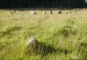
A Row of Three Stones (Alignment) in Co. Down, one of which has fallen.
Have you visited this site? Please contribute a description or any thoughts by adding a comment.
You may be viewing yesterday's version of this page. To see the most up to date information please register for a free account.
Do not use the above information on other web sites or publications without permission of the contributor.
coldrum has found this location on Google Street View:
Nearby Images from Geograph Britain and Ireland:
©2006(licence)
©2006(licence)
©2006(licence)
©2006(licence)
©2007(licence)
The above images may not be of the site on this page, they are loaded from Geograph.
Please Submit an Image of this site or go out and take one for us!
Click here to see more info for this site
Nearby sites
Click here to view sites on an interactive map of the areaKey: Red: member's photo, Blue: 3rd party photo, Yellow: other image, Green: no photo - please go there and take one, Grey: site destroyed
Download sites to:
KML (Google Earth)
GPX (GPS waypoints)
CSV (Garmin/Navman)
CSV (Excel)
To unlock full downloads you need to sign up as a Contributory Member. Otherwise downloads are limited to 50 sites.
Turn off the page maps and other distractions
Nearby sites listing. In the following links * = Image available
964m ENE 76° Drumnahare* Standing Stone (Menhir) (J111415)
6.3km S 179° Donaghmore High Cross Ancient Cross (J1044334964)
8.8km ESE 114° Knockiveagh* Cairn
10.2km S 171° Killybeg* Standing Stones (J121312)
10.2km S 170° Saval More Stone Pair* Standing Stones
10.8km SE 141° Barnmeen* Standing Stone (Menhir) (J172330)
13.5km S 173° Crobane* Standing Stone (Menhir) (J121279)
14.6km SSW 212° Eswary Court Tomb* Court Tomb (J0270428676)
14.8km SSW 212° Eswary Stone Row* Stone Row / Alignment (J025285)
15.2km E 96° Moneyslane* Standing Stones
16.1km SSE 165° Edenmore Court Tomb (J14752583)
16.6km SSE 149° Mullaghmore (Co. Down)* Stone Circle (J191272)
17.5km SE 127° Goward* Portal Tomb (J244310)
17.6km SSW 193° Ballymacdermot* Court Tomb (J06562403)
17.6km SSE 164° Tamnaharry* Standing Stone (Menhir)
18.8km W 267° Vicar's Cairn* Passage Grave
18.8km E 85° Legananny* Portal Tomb (J2886743397)
19.8km SSW 207° Ballard Longstone* Standing Stone (Menhir) (J01622337)
20.2km E 87° Legananny Cross Stone* Ancient Cross (J304428)
20.7km SSW 207° St Moninna's Holy Well (Killevy)* Holy Well or Sacred Spring (J010226)
21.2km W 264° Bull's Stone (Ballymacnab)* Ancient Cross (H89033855)
21.8km S 182° Clontygora* Court Tomb (J0986519419)
21.8km S 182° Clontygora E* Wedge Tomb
22.1km ESE 110° Drumena* Stone Fort or Dun (J3111034018)
22.3km SSW 202° Slieve Gullion* Chambered Tomb (J02482033)
View more nearby sites and additional images


 We would like to know more about this location. Please feel free to add a brief description and any relevant information in your own language.
 Wir möchten mehr über diese Stätte erfahren. Bitte zögern Sie nicht, eine kurze Beschreibung und relevante Informationen in Deutsch hinzuzufügen.
 Nous aimerions en savoir encore un peu sur les lieux. S'il vous plaît n'hesitez pas à ajouter une courte description et tous les renseignements pertinents dans votre propre langue.
 Quisieramos informarnos un poco más de las lugares. No dude en añadir una breve descripción y otros datos relevantes en su propio idioma.