


<< Text Pages >> Dun Ban, Tostarie - Stone Fort or Dun in Scotland in Isle of Mull
Submitted by Andy B on Tuesday, 19 October 2010 Page Views: 2763
Multi-periodSite Name: Dun Ban, TostarieCountry: Scotland County: Isle of Mull Type: Stone Fort or Dun
Map Ref: NM38694524
Latitude: 56.526330N Longitude: 6.250736W
Condition:
| 5 | Perfect |
| 4 | Almost Perfect |
| 3 | Reasonable but with some damage |
| 2 | Ruined but still recognisable as an ancient site |
| 1 | Pretty much destroyed, possibly visible as crop marks |
| 0 | No data. |
| -1 | Completely destroyed |
| 5 | Superb |
| 4 | Good |
| 3 | Ordinary |
| 2 | Not Good |
| 1 | Awful |
| 0 | No data. |
| 5 | Can be driven to, probably with disabled access |
| 4 | Short walk on a footpath |
| 3 | Requiring a bit more of a walk |
| 2 | A long walk |
| 1 | In the middle of nowhere, a nightmare to find |
| 0 | No data. |
| 5 | co-ordinates taken by GPS or official recorded co-ordinates |
| 4 | co-ordinates scaled from a detailed map |
| 3 | co-ordinates scaled from a bad map |
| 2 | co-ordinates of the nearest village |
| 1 | co-ordinates of the nearest town |
| 0 | no data |
Be the first person to rate this site - see the 'Contribute!' box in the right hand menu.
Internal Links:
External Links:
Stone Fort or Dun in Isle of Mull
Dun, Dun Ban, Tostarie: This dun, locally known as Dun Ban, occupies the level summit of a rocky crag situated on the seashore some 500m SW of Tostarie. The position is protected by almost vertical rock-faces, which range from 5m on the S (seaward) side to 3m on the N. Access to the dun was probably gained by way of a small natural cleft in the landward side of the spur that slopes gradually down from the summit on the NNE.
The dun, which measured over all about 12m from NE to SW by 10.5m transversely, was defended by a stone wall drawn round the margin of the summit area. Apart from a portion which has been totally destroyed on the S, the wall survives as a low grass-grown band of stony debris, in which two stretches of outer facing-stones can still be seen, the easternmost standing up to 1m high in five courses. No inner facing-stones are visible. The position of the entrance is indicated by a gap in the debris on the NE. The interior is featureless.
Source: Canmore
You may be viewing yesterday's version of this page. To see the most up to date information please register for a free account.
Do not use the above information on other web sites or publications without permission of the contributor.
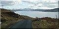
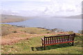
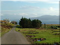
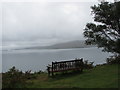
Nearby Images from Geograph Britain and Ireland:
©2016(licence)
©2011(licence)
©2008(licence)
©2010(licence)
©2015(licence)
The above images may not be of the site on this page, they are loaded from Geograph.
Please Submit an Image of this site or go out and take one for us!
Click here to see more info for this site
Nearby sites
Key: Red: member's photo, Blue: 3rd party photo, Yellow: other image, Green: no photo - please go there and take one, Grey: site destroyed
Download sites to:
KML (Google Earth)
GPX (GPS waypoints)
CSV (Garmin/Navman)
CSV (Excel)
To unlock full downloads you need to sign up as a Contributory Member. Otherwise downloads are limited to 50 sites.
Turn off the page maps and other distractions
Nearby sites listing. In the following links * = Image available
615m NE 49° Tostarie* Standing Stone (Menhir) (NM3918145614)
764m ENE 71° Torr Damh* Cairn (NM39434544)
946m W 266° Dun Aisgain Stone Fort or Dun (NM37744524)
1.2km ENE 60° Tobar Ninian* Holy Well or Sacred Spring (NM3976545784)
5.0km ESE 109° Dun nan Gall* Broch or Nuraghe (NM43344331)
5.2km NW 323° Creag A' Chaisteal Rock Art (NM35874957)
5.4km SSW 195° Tigh An Duine Stone Fort or Dun (NM36944013)
5.7km WNW 290° Dun Haunn Stone Fort or Dun (NM33434749)
5.8km ESE 108° Dun Choinichean Stone Fort or Dun (NM44094312)
6.4km NE 38° Torr A'chlachain, Mull Hillfort (NM42945000)
6.4km SSE 162° Cragaig* Standing Stones (NM40283901)
6.6km NNW 339° Calgary Pier Stone Fort or Dun (NM36705151)
7.1km N 355° Calgary* Stone Row / Alignment (NM38495231)
7.1km SE 144° Ulva Standing Stone Standing Stone (Menhir) (NM42563926)
7.2km NNE 14° Dun Auladh Round Cairn (NM40815212)
7.3km NE 46° Torr Aint* Hillfort (NM44265005)
7.4km N 360° Dun Mhadaidh* Stone Fort or Dun (NM39145260)
7.5km NE 36° Aintuim Cairn Round Cairn (NM43445103)
7.9km NNE 28° Torr A'mhanaich Hillfort (NM42855192)
8.2km NE 35° Dervaig SSE* Stone Row / Alignment (NM4385951655)
8.2km NNW 344° Allt Cill Chriosd Stone Fort or Dun (NM36885328)
8.3km N 349° Cillchriosd Rock Art (NM37665347)
8.3km N 350° Cillchriosd* Standing Stone (Menhir) (NM3772553502)
8.4km NNW 340° Lag Standing Stones* Standing Stones (NM3626753307)
8.4km NE 35° Priest's Well (Dervaig)* Holy Well or Sacred Spring (NM440518)
View more nearby sites and additional images


 We would like to know more about this location. Please feel free to add a brief description and any relevant information in your own language.
 Wir möchten mehr über diese Stätte erfahren. Bitte zögern Sie nicht, eine kurze Beschreibung und relevante Informationen in Deutsch hinzuzufügen.
 Nous aimerions en savoir encore un peu sur les lieux. S'il vous plaît n'hesitez pas à ajouter une courte description et tous les renseignements pertinents dans votre propre langue.
 Quisieramos informarnos un poco más de las lugares. No dude en añadir una breve descripción y otros datos relevantes en su propio idioma.