

<< Our Photo Pages >> Mullach Dubh - Standing Stone (Menhir) in Scotland in Isle of Islay
Submitted by Anonymous on Monday, 11 November 2002 Page Views: 5448
Neolithic and Bronze AgeSite Name: Mullach DubhCountry: Scotland
NOTE: This site is 3.765 km away from the location you searched for.
County: Isle of Islay Type: Standing Stone (Menhir)
Map Ref: NR40366412 Landranger Map Number: 60
Latitude: 55.800381N Longitude: 6.1445W
Condition:
| 5 | Perfect |
| 4 | Almost Perfect |
| 3 | Reasonable but with some damage |
| 2 | Ruined but still recognisable as an ancient site |
| 1 | Pretty much destroyed, possibly visible as crop marks |
| 0 | No data. |
| -1 | Completely destroyed |
| 5 | Superb |
| 4 | Good |
| 3 | Ordinary |
| 2 | Not Good |
| 1 | Awful |
| 0 | No data. |
| 5 | Can be driven to, probably with disabled access |
| 4 | Short walk on a footpath |
| 3 | Requiring a bit more of a walk |
| 2 | A long walk |
| 1 | In the middle of nowhere, a nightmare to find |
| 0 | No data. |
| 5 | co-ordinates taken by GPS or official recorded co-ordinates |
| 4 | co-ordinates scaled from a detailed map |
| 3 | co-ordinates scaled from a bad map |
| 2 | co-ordinates of the nearest village |
| 1 | co-ordinates of the nearest town |
| 0 | no data |
Internal Links:
External Links:
I have visited· I would like to visit
Andy B has visited here
")
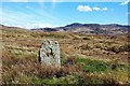
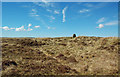
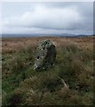
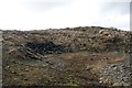
Standing stone near Kilmeny, Islay The limestone stone is about 1.3m high. Part of it has broken off and is embedded in the ground nearby.
Canmore site no. 38135.
You may be viewing yesterday's version of this page. To see the most up to date information please register for a free account.
Do not use the above information on other web sites or publications without permission of the contributor.
Nearby Images from Geograph Britain and Ireland:
©2019(licence)
©2019(licence)
©2013(licence)
©2006(licence)
©2013(licence)
The above images may not be of the site on this page, they are loaded from Geograph.
Please Submit an Image of this site or go out and take one for us!
Click here to see more info for this site
Nearby sites
Key: Red: member's photo, Blue: 3rd party photo, Yellow: other image, Green: no photo - please go there and take one, Grey: site destroyed
Download sites to:
KML (Google Earth)
GPX (GPS waypoints)
CSV (Garmin/Navman)
CSV (Excel)
To unlock full downloads you need to sign up as a Contributory Member. Otherwise downloads are limited to 50 sites.
![]()
Turn off the page maps and other distractions
Nearby sites listing. In the following links * = Image available
874m NW 324° Knocklearoch* Standing Stones (NR3989164860)
3.2km N 10° Scanistle Standing Stone (Menhir) (NR41086724)
4.6km NNW 343° Finlaggan* Standing Stone (Menhir) (NR3927668559)
5.3km SW 235° Gortanilivorrie Standing Stone (Menhir) (NR35816138)
5.3km NW 308° Baile Tarbhach Standing Stone (Menhir) (NR36366762)
5.7km SW 227° Neriby (Bridgend) Standing Stone (Menhir) (NR35956053)
6.1km E 80° Camas An Staca* Standing Stone (Menhir) (NR46416479)
6.6km WNW 301° Beinn Cham Standing Stones (NR349679)
6.7km W 268° Knockdon Standing Stone (Menhir) (NR33616424)
7.9km NW 312° Clach an Tiompain Standing Stone (Menhir) (NR34756977)
9.3km W 262° Tayandock* Standing Stone (Menhir) (NR31016341)
10.1km E 92° Cladh Chlainn Iain* Chambered Cairn (NR50476315)
10.4km E 89° Strone Farm* Standing Stones (NR50786375)
11.0km W 263° Uiskentuie* Standing Stone (Menhir) (NR29386336)
11.1km ENE 74° Carragh a'Ghlinne* Stone Row / Alignment (NR5128566490)
11.4km SE 144° Ardtalla Standing Stone (Menhir) (NR46575456)
11.5km E 83° Sannaig* Stone Row / Alignment (NR51846480)
12.7km SSE 149° Trudernish* Standing Stone (Menhir) (NR46295290)
13.4km W 267° Foreland House Standing Stone (Menhir) (NR269643)
13.9km WNW 299° St Nem's Churchyard (Kilnave)* Ancient Cross (NR285715)
14.3km SSE 154° Kildalton Cross* Ancient Cross (NR4580250830)
14.3km W 277° Glacan Daraich Ancient Village or Settlement (NR262667)
14.7km WNW 302° Ardnave Loch* Crannog (NR28317263)
15.4km WSW 256° Gartacharra* Standing Stone (Menhir) (NR252613)
15.4km SSE 162° Ardilistry* Stone Circle (NR44264919)
View more nearby sites and additional images


 We would like to know more about this location. Please feel free to add a brief description and any relevant information in your own language.
 Wir möchten mehr über diese Stätte erfahren. Bitte zögern Sie nicht, eine kurze Beschreibung und relevante Informationen in Deutsch hinzuzufügen.
 Nous aimerions en savoir encore un peu sur les lieux. S'il vous plaît n'hesitez pas à ajouter une courte description et tous les renseignements pertinents dans votre propre langue.
 Quisieramos informarnos un poco más de las lugares. No dude en añadir una breve descripción y otros datos relevantes en su propio idioma.