


<< Our Photo Pages >> Galboly Upper - Passage Grave in Ireland (Northern) in Co. Antrim
Submitted by ainsloch on Tuesday, 23 July 2013 Page Views: 6187
Neolithic and Bronze AgeSite Name: Galboly UpperCountry: Ireland (Northern)
NOTE: This site is 6.768 km away from the location you searched for.
County: Co. Antrim Type: Passage Grave
Nearest Town: Larne Nearest Village: Galboly Lower
Map Ref: D2900724454
Latitude: 55.050705N Longitude: 5.982215W
Condition:
| 5 | Perfect |
| 4 | Almost Perfect |
| 3 | Reasonable but with some damage |
| 2 | Ruined but still recognisable as an ancient site |
| 1 | Pretty much destroyed, possibly visible as crop marks |
| 0 | No data. |
| -1 | Completely destroyed |
| 5 | Superb |
| 4 | Good |
| 3 | Ordinary |
| 2 | Not Good |
| 1 | Awful |
| 0 | No data. |
| 5 | Can be driven to, probably with disabled access |
| 4 | Short walk on a footpath |
| 3 | Requiring a bit more of a walk |
| 2 | A long walk |
| 1 | In the middle of nowhere, a nightmare to find |
| 0 | No data. |
| 5 | co-ordinates taken by GPS or official recorded co-ordinates |
| 4 | co-ordinates scaled from a detailed map |
| 3 | co-ordinates scaled from a bad map |
| 2 | co-ordinates of the nearest village |
| 1 | co-ordinates of the nearest town |
| 0 | no data |
Internal Links:
External Links:
")
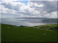
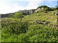
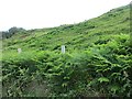
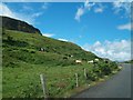
The Galboly monuments are enigmatic sites, since they are not shown on the local OS map, nor do they appear in the scheduled monuments list for Northern Ireland. The reasons for this are unclear but in some ways this particular region is the most striking of all the Co. Antrim passage mound sites. There is a small dolmen like passage mound situated in Galboly Lower, not far from the coast road, and then three tombs situated higher up and farther back from the road on a plateau. Two of these are pretty ruinous but the third (pictured here) has all the characteristics of a small dolmen type passage mound of the Co. Antrim variety. The scenery here is remarkable - the local area includes a deserted village, breathtaking cliffs, rolling countryside, the sea, and hidden lakes.
You may be viewing yesterday's version of this page. To see the most up to date information please register for a free account.
")
")
Do not use the above information on other web sites or publications without permission of the contributor.
Nearby Images from Geograph Britain and Ireland:
©2005(licence)
©2007(licence)
©2010(licence)
©2014(licence)
©2011(licence)
The above images may not be of the site on this page, they are loaded from Geograph.
Please Submit an Image of this site or go out and take one for us!
Click here to see more info for this site
Nearby sites
Click here to view sites on an interactive map of the areaKey: Red: member's photo, Blue: 3rd party photo, Yellow: other image, Green: no photo - please go there and take one, Grey: site destroyed
Download sites to:
KML (Google Earth)
GPX (GPS waypoints)
CSV (Garmin/Navman)
CSV (Excel)
To unlock full downloads you need to sign up as a Contributory Member. Otherwise downloads are limited to 50 sites.
Turn off the page maps and other distractions
Nearby sites listing. In the following links * = Image available
516m NNE 31° Galboly Lower* Passage Grave
4.6km W 268° Cross-Carved Stone and Children's Burial Ground* Early Christian Sculptured Stone (NW411803)
8.7km WNW 299° Ossian's Grave* Court Tomb
8.8km WNW 295° Cloghs* Passage Grave
9.5km NW 326° The Gloonan Stone (Craigagh)* Natural Stone / Erratic / Other Natural Feature (D23363218)
9.7km NNW 338° Ballycleagh* Stone Row / Alignment (D251333)
10.0km WNW 285° Tievebulliagh Ancient Mine, Quarry or other Industry (D193268)
11.2km NNW 340° Altagore* Stone Fort or Dun (D2494734883)
11.5km NNW 343° Chambered Grave (Tornamoney)* Chambered Tomb (NW430913)
12.1km NNW 328° Cushleake Mountain Stone Circle (D223345)
13.1km SSW 208° Ticloy* Portal Tomb (D232127)
13.9km S 171° Goakstown* Wedge Tomb
13.9km SSW 196° Antynanum* Court Tomb (D25561094)
14.1km S 172° Deer Park Farms* Standing Stone (Menhir) (NW470661)
14.7km SSE 164° Ballygilbert* Standing Stone (Menhir) (D334104)
14.9km NW 317° Ballyvennaght Court Tomb * Court Tomb (D1844035020)
15.2km SSW 198° Tamybuck Wedge Tomb* Wedge Tomb (NW401660)
15.2km NW 325° Ballyvennaght Portal Tomb* Portal Tomb (D1998036750)
15.3km NNW 329° Cloughananca 2* Portal Tomb (D2074037330)
15.4km NW 326° Stone of Sorrows (Cloch na h-Uaighe)* Standing Stone (Menhir) (NW379934)
16.0km NNW 335° Carnanmore* Passage Grave (D218388)
16.8km S 170° Dunteige* Wedge Tomb (D32350798)
17.4km WNW 298° McQuillan's Grave* Chambered Tomb (D1339032140)
17.6km SSE 168° Linford Round Cairn Round Cairn
17.6km NW 308° Duncarbit Standing Stones* Standing Stones (D1473434814)
View more nearby sites and additional images


 We would like to know more about this location. Please feel free to add a brief description and any relevant information in your own language.
 Wir möchten mehr über diese Stätte erfahren. Bitte zögern Sie nicht, eine kurze Beschreibung und relevante Informationen in Deutsch hinzuzufügen.
 Nous aimerions en savoir encore un peu sur les lieux. S'il vous plaît n'hesitez pas à ajouter une courte description et tous les renseignements pertinents dans votre propre langue.
 Quisieramos informarnos un poco más de las lugares. No dude en añadir una breve descripción y otros datos relevantes en su propio idioma.