<< Our Photo Pages >> Giant's Well (St. Michael's Mount) - Holy Well or Sacred Spring in England in Cornwall
Submitted by vicky on Monday, 29 March 2004 Page Views: 14710
Springs and Holy WellsSite Name: Giant's Well (St. Michael's Mount) Alternative Name: St. Michael's Mount Well,Jack the Giant Killer's WellCountry: England
NOTE: This site is 1.521 km away from the location you searched for.
County: Cornwall Type: Holy Well or Sacred Spring
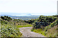
Nearest Town: Penzance Nearest Village: Marazion
Map Ref: SW516299 Landranger Map Number: 203
Latitude: 50.117089N Longitude: 5.476093W
Condition:
| 5 | Perfect |
| 4 | Almost Perfect |
| 3 | Reasonable but with some damage |
| 2 | Ruined but still recognisable as an ancient site |
| 1 | Pretty much destroyed, possibly visible as crop marks |
| 0 | No data. |
| -1 | Completely destroyed |
| 5 | Superb |
| 4 | Good |
| 3 | Ordinary |
| 2 | Not Good |
| 1 | Awful |
| 0 | No data. |
| 5 | Can be driven to, probably with disabled access |
| 4 | Short walk on a footpath |
| 3 | Requiring a bit more of a walk |
| 2 | A long walk |
| 1 | In the middle of nowhere, a nightmare to find |
| 0 | No data. |
| 5 | co-ordinates taken by GPS or official recorded co-ordinates |
| 4 | co-ordinates scaled from a detailed map |
| 3 | co-ordinates scaled from a bad map |
| 2 | co-ordinates of the nearest village |
| 1 | co-ordinates of the nearest town |
| 0 | no data |
Internal Links:
External Links:
I have visited· I would like to visit
SolarMegalith would like to visit
bishop_pam visited on 25th Nov 2022 - their rating: Cond: 5 Amb: 4 Access: 3
cazzyjane have visited here
 (PID:13493)")
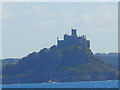
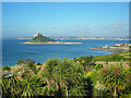
Legend says that this was the home of the giants Cormoran and his wife Cormelian. Jack defeated Cormoran after the giant terrorised local lands.
Near the well is a stone named the Giant's Heart.
You may be viewing yesterday's version of this page. To see the most up to date information please register for a free account.
 (PID:13494)")
 (PID:200156)")
Do not use the above information on other web sites or publications without permission of the contributor.
Nearby Images from Geograph Britain and Ireland:
©2015(licence)
©2008(licence)
©2023(licence)
©2010(licence)
©2013(licence)
The above images may not be of the site on this page, they are loaded from Geograph.
Please Submit an Image of this site or go out and take one for us!
Click here to see more info for this site
Nearby sites
Key: Red: member's photo, Blue: 3rd party photo, Yellow: other image, Green: no photo - please go there and take one, Grey: site destroyed
Download sites to:
KML (Google Earth)
GPX (GPS waypoints)
CSV (Garmin/Navman)
CSV (Excel)
To unlock full downloads you need to sign up as a Contributory Member. Otherwise downloads are limited to 50 sites.
Turn off the page maps and other distractions
Nearby sites listing. In the following links * = Image available
100m W 267° St Michael's Mount* Ancient Village or Settlement (SW515299)
223m WSW 241° St Michael's Mount crosses* Ancient Cross (SW514298)
2.7km N 351° Bowgyheere Barrow Cemetery* Barrow Cemetery (SW51313256)
2.9km WNW 288° Mounts Bay prehistoric submerged forest* Natural Stone / Erratic / Other Natural Feature (SW489309)
3.2km NW 325° Tregarthen hedge stone* Standing Stone (Menhir) (SW4986332625)
3.3km NNW 338° Ludgvan Crosses* Ancient Cross (SW50503305)
3.4km N 349° Crowlas holed stone* Holed Stone (SW51133325)
3.4km NW 315° Tolver Hut site and Outcrop* Rock Outcrop (SW493324)
3.6km WNW 298° Gulval inscribed cross shaft* Ancient Cross (SW4846131744)
3.7km ENE 65° St Hilary's inscribed stone* Sculptured Stone (SW55033127)
3.9km N 5° Tregender Cross* Ancient Cross (SW5212333747)
4.0km NW 316° Tremenheere Standing Stone* Standing Stone (Menhir) (SW490329)
4.0km ESE 122° Cudden Point* Rock Outcrop (SW549276)
4.0km W 269° St Mary's Cross* Ancient Cross (SW47543001)
4.1km WNW 283° Lescudjack Castle* Hillfort (SW476310)
4.3km NNW 348° St Michael's standing stone* Modern Stone Circle etc (SW509341)
4.4km WNW 292° Bleu Bridge* Early Christian Sculptured Stone (SW476317)
4.5km N 0° Tregellas Well* Holy Well or Sacred Spring (SW5183734388)
4.6km W 269° Penzance Market Cross* Ancient Cross (SW47033003)
4.6km N 8° Whitecross (Penwith)* Ancient Cross (SW5248534390)
4.7km E 81° Colenso Round* Ancient Village or Settlement (SW563304)
4.7km WNW 301° Rosemorran Cross* Ancient Cross (SW47653255)
4.8km WNW 300° Rosemorran* Standing Stone (Menhir) (SW475325)
4.8km N 6° Collurian Well Holy Well or Sacred Spring (SW523347)
5.3km NNW 336° Gear Hut Circle and Round* Ancient Village or Settlement (SW49653484)
View more nearby sites and additional images


 We would like to know more about this location. Please feel free to add a brief description and any relevant information in your own language.
 Wir möchten mehr über diese Stätte erfahren. Bitte zögern Sie nicht, eine kurze Beschreibung und relevante Informationen in Deutsch hinzuzufügen.
 Nous aimerions en savoir encore un peu sur les lieux. S'il vous plaît n'hesitez pas à ajouter une courte description et tous les renseignements pertinents dans votre propre langue.
 Quisieramos informarnos un poco más de las lugares. No dude en añadir una breve descripción y otros datos relevantes en su propio idioma.