<< Our Photo Pages >> Carr Brae - Rock Art in Scotland in Highlands
Submitted by uisdean on Thursday, 08 February 2007 Page Views: 7069
Rock ArtSite Name: Carr BraeCountry: Scotland
NOTE: This site is 2.364 km away from the location you searched for.
County: Highlands Type: Rock Art
Nearest Village: Inverinate
Map Ref: NG89782451
Latitude: 57.262768N Longitude: 5.487565W
Condition:
| 5 | Perfect |
| 4 | Almost Perfect |
| 3 | Reasonable but with some damage |
| 2 | Ruined but still recognisable as an ancient site |
| 1 | Pretty much destroyed, possibly visible as crop marks |
| 0 | No data. |
| -1 | Completely destroyed |
| 5 | Superb |
| 4 | Good |
| 3 | Ordinary |
| 2 | Not Good |
| 1 | Awful |
| 0 | No data. |
| 5 | Can be driven to, probably with disabled access |
| 4 | Short walk on a footpath |
| 3 | Requiring a bit more of a walk |
| 2 | A long walk |
| 1 | In the middle of nowhere, a nightmare to find |
| 0 | No data. |
| 5 | co-ordinates taken by GPS or official recorded co-ordinates |
| 4 | co-ordinates scaled from a detailed map |
| 3 | co-ordinates scaled from a bad map |
| 2 | co-ordinates of the nearest village |
| 1 | co-ordinates of the nearest town |
| 0 | no data |
Internal Links:
External Links:
")
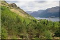
On the old road from Inverinate to Dornie, about 100 metres below the sheep fank which is about 300 metres before the viewpoint of Carr Brae, is a cup marked boulder some 1.8 metres long having a number of cup marks (but no rings), some well defined. The site commands extensive views south to the Five Sisters of Kintail and the South Kintail Ridge. A second boulder 2 metres uphill is shaped like a snake's head.
You may be viewing yesterday's version of this page. To see the most up to date information please register for a free account.
")
")
Do not use the above information on other web sites or publications without permission of the contributor.
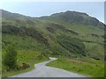
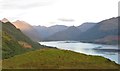
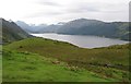
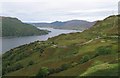
Nearby Images from Geograph Britain and Ireland:
©2013(licence)
©2019(licence)
©2008(licence)
©2008(licence)
©2017(licence)
The above images may not be of the site on this page, they are loaded from Geograph.
Please Submit an Image of this site or go out and take one for us!
Click here to see more info for this site
Nearby sites
Key: Red: member's photo, Blue: 3rd party photo, Yellow: other image, Green: no photo - please go there and take one, Grey: site destroyed
Download sites to:
KML (Google Earth)
GPX (GPS waypoints)
CSV (Garmin/Navman)
CSV (Excel)
To unlock full downloads you need to sign up as a Contributory Member. Otherwise downloads are limited to 50 sites.
Turn off the page maps and other distractions
Nearby sites listing. In the following links * = Image available
1.8km SSW 207° Allt an Inbhir Souterrain* Souterrain (Fogou, Earth House) (NG88882296)
2.1km SW 220° Torran a'Bharraich* Hillfort (NG88312296)
2.5km WNW 287° Totaig Cup Markings* Rock Art (NG87432536)
3.1km WNW 282° Dun Totaig (Loch Duich) Broch or Nuraghe (NG868253)
3.1km W 278° Caisteal Grugaig* Broch or Nuraghe (NG86692508)
3.4km N 358° Bard's Castle* Hillfort (NG89822790)
5.6km SE 128° Diarmaid's Grave* Standing Stones (NG93992085)
5.6km SE 129° Dunan Diarmaid* Hillfort (NG93952071)
5.7km WNW 301° Dun Gleann Udalain Stone Fort or Dun (NG85062773)
5.7km ESE 122° Tigh Geal* Rock Art (NG94452120)
6.2km ESE 117° Croe Bridge* Rock Art (NG95162141)
6.5km SW 226° Serpent Mound (Scallasaig) Cairn (NG8484020288)
6.6km NE 43° Camas Luinie* Rock Art (NG94492909)
6.7km SSE 148° Sheil Henge* Henge (NG93081868)
6.8km NW 313° Gleann Udalain Cairn Cairn (NG85092942)
7.0km NE 51° Faddoch* Rock Art (NG95452863)
7.0km SE 142° Cill Fhearchair* Standing Stone (Menhir) (NG93871879)
7.2km WNW 291° Angels' Hill, Kirkton* Hillfort (NG83142745)
7.3km WNW 290° Lochalsh* Stone Circle (NG831274)
7.5km ESE 109° Lienassie* Rock Art (NG968217)
7.7km WNW 291° Dun Kirkton Stone Fort or Dun (NG82722768)
8.5km WSW 241° Am Baghan Galldair* Stone Fort or Dun (NG82162075)
8.7km SW 234° An Dun (Barnhill)* Stone Fort or Dun (NG82441972)
9.5km SSW 211° Balvraid Chambered Cairn* Chambered Cairn (NG8452416627)
9.5km SSW 208° Balvraid Cup Marked Stone* Rock Art (NG84961635)
View more nearby sites and additional images


 We would like to know more about this location. Please feel free to add a brief description and any relevant information in your own language.
 Wir möchten mehr über diese Stätte erfahren. Bitte zögern Sie nicht, eine kurze Beschreibung und relevante Informationen in Deutsch hinzuzufügen.
 Nous aimerions en savoir encore un peu sur les lieux. S'il vous plaît n'hesitez pas à ajouter une courte description et tous les renseignements pertinents dans votre propre langue.
 Quisieramos informarnos un poco más de las lugares. No dude en añadir una breve descripción y otros datos relevantes en su propio idioma.