<< Our Photo Pages >> Uaigh Finnach - Standing Stone (Menhir) in Scotland in Isle of Arran
Submitted by davidmorgan on Friday, 03 April 2015 Page Views: 1954
Neolithic and Bronze AgeSite Name: Uaigh FinnachCountry: Scotland
NOTE: This site is 2.022 km away from the location you searched for.
County: Isle of Arran Type: Standing Stone (Menhir)
Nearest Town: Brodick Nearest Village: Ballymichael
Map Ref: NR9261631040
Latitude: 55.528904N Longitude: 5.287433W
Condition:
| 5 | Perfect |
| 4 | Almost Perfect |
| 3 | Reasonable but with some damage |
| 2 | Ruined but still recognisable as an ancient site |
| 1 | Pretty much destroyed, possibly visible as crop marks |
| 0 | No data. |
| -1 | Completely destroyed |
| 5 | Superb |
| 4 | Good |
| 3 | Ordinary |
| 2 | Not Good |
| 1 | Awful |
| 0 | No data. |
| 5 | Can be driven to, probably with disabled access |
| 4 | Short walk on a footpath |
| 3 | Requiring a bit more of a walk |
| 2 | A long walk |
| 1 | In the middle of nowhere, a nightmare to find |
| 0 | No data. |
| 5 | co-ordinates taken by GPS or official recorded co-ordinates |
| 4 | co-ordinates scaled from a detailed map |
| 3 | co-ordinates scaled from a bad map |
| 2 | co-ordinates of the nearest village |
| 1 | co-ordinates of the nearest town |
| 0 | no data |
Internal Links:
External Links:
")
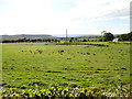
A possible fallen standing stone, 3 metres long. Through a rusty farm gate in a hedge which faces B880 road at the point that is indicated 'MS 52' on the OS Explorer map 361, you can easily reach this lying stone.
Canmore site no. 39713
You may be viewing yesterday's version of this page. To see the most up to date information please register for a free account.
")
Do not use the above information on other web sites or publications without permission of the contributor.
Nearby Images from Geograph Britain and Ireland:
©2019(licence)
©2020(licence)
©2012(licence)
©2019(licence)
©2012(licence)
The above images may not be of the site on this page, they are loaded from Geograph.
Please Submit an Image of this site or go out and take one for us!
Click here to see more info for this site
Nearby sites
Key: Red: member's photo, Blue: 3rd party photo, Yellow: other image, Green: no photo - please go there and take one, Grey: site destroyed
Download sites to:
KML (Google Earth)
GPX (GPS waypoints)
CSV (Garmin/Navman)
CSV (Excel)
To unlock full downloads you need to sign up as a Contributory Member. Otherwise downloads are limited to 50 sites.
Turn off the page maps and other distractions
Nearby sites listing. In the following links * = Image available
182m NNE 32° Ballymichael Standing Stones* Standing Stones (NR92723119)
1.2km N 349° Shiskine* Stone Circle (NR92443225)
1.6km NNW 332° Ballymichael Bridge* Stone Circle (NR91913252)
1.8km ESE 112° Clauchan Glen Standing Stone (Menhir) (NR94283029)
2.0km NW 312° Machrie Moor 6* Stone Circle (NR91223242)
2.0km NW 311° Machrie Moor 1.* Stone Circle (NR91203240)
2.0km NW 311° Machrie Moor 11 Timber Circle (NR912324)
2.0km NW 310° Machrie Moor 2* Stone Circle (NR91143242)
2.1km NW 307° Machrie Moor 4* Stone Circle (NR91003236)
2.1km NW 309° Machrie Moor 3* Stone Circle (NR91013245)
2.2km NW 304° Machrie Moor 5* Stone Circle (NR90883235)
2.3km WNW 303° Moss farm chambered cairn* Chambered Cairn (NR90753237)
2.3km W 268° Tormore 1 Chambered Cairn (NR90313106)
2.4km WNW 300° Tormore 2* Chambered Cairn (NR90583237)
2.5km NW 305° Moss Farm Stone* Standing Stone (Menhir) (NR90643254)
3.0km WNW 300° Machrie Moor 10* Stone Circle (NR90063265)
3.4km WSW 245° Torbeg Cursus* Cursus (NR8950329741)
3.4km WNW 291° Tormore Farm Chambered Cairn (NR89453242)
3.9km NNW 333° Cnoc Na Ceille* Standing Stone (Menhir) (NR9101034553)
4.1km NW 307° Machriewaterfoot Standing Stone* Standing Stone (Menhir) (NR89453363)
4.2km W 266° Kings Cave* Cave or Rock Shelter (NR88443092)
4.3km WSW 245° Drumadoon Hillfort* Hillfort
4.3km WSW 243° Drummadoon Standing Stone* Standing Stone (Menhir) (NR8865629273)
4.4km WSW 243° Drumidoon* Stone Circle (NR886292)
4.4km SSW 193° Carmahome Passage Grave (NR914268)
View more nearby sites and additional images


 We would like to know more about this location. Please feel free to add a brief description and any relevant information in your own language.
 Wir möchten mehr über diese Stätte erfahren. Bitte zögern Sie nicht, eine kurze Beschreibung und relevante Informationen in Deutsch hinzuzufügen.
 Nous aimerions en savoir encore un peu sur les lieux. S'il vous plaît n'hesitez pas à ajouter une courte description et tous les renseignements pertinents dans votre propre langue.
 Quisieramos informarnos un poco más de las lugares. No dude en añadir una breve descripción y otros datos relevantes en su propio idioma.