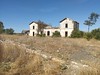
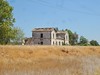
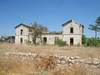
<< Text Pages >> Villa Romana de Fuente Álamo - Ancient Village or Settlement in Spain in Andalucía
Submitted by holger_rix on Friday, 04 December 2015 Page Views: 1271
Multi-periodSite Name: Villa Romana de Fuente ÁlamoCountry: Spain
NOTE: This site is 23.973 km away from the location you searched for.
Region: Andalucía Type: Ancient Village or Settlement
Nearest Town: Puente Genil
Latitude: 37.418040N Longitude: 4.72588W
Condition:
| 5 | Perfect |
| 4 | Almost Perfect |
| 3 | Reasonable but with some damage |
| 2 | Ruined but still recognisable as an ancient site |
| 1 | Pretty much destroyed, possibly visible as crop marks |
| 0 | No data. |
| -1 | Completely destroyed |
| 5 | Superb |
| 4 | Good |
| 3 | Ordinary |
| 2 | Not Good |
| 1 | Awful |
| 0 | No data. |
| 5 | Can be driven to, probably with disabled access |
| 4 | Short walk on a footpath |
| 3 | Requiring a bit more of a walk |
| 2 | A long walk |
| 1 | In the middle of nowhere, a nightmare to find |
| 0 | No data. |
| 5 | co-ordinates taken by GPS or official recorded co-ordinates |
| 4 | co-ordinates scaled from a detailed map |
| 3 | co-ordinates scaled from a bad map |
| 2 | co-ordinates of the nearest village |
| 1 | co-ordinates of the nearest town |
| 0 | no data |
Be the first person to rate this site - see the 'Contribute!' box in the right hand menu.
Internal Links:
External Links:
Ancient Village or Settlement in Andalucía
You may be viewing yesterday's version of this page. To see the most up to date information please register for a free account.
Do not use the above information on other web sites or publications without permission of the contributor.
Nearby Images from Flickr
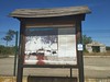
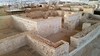
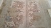
The above images may not be of the site on this page, but were taken nearby. They are loaded from Flickr so please click on them for image credits.
Click here to see more info for this site
Nearby sites
Click here to view sites on an interactive map of the areaKey: Red: member's photo, Blue: 3rd party photo, Yellow: other image, Green: no photo - please go there and take one, Grey: site destroyed
Download sites to:
KML (Google Earth)
GPX (GPS waypoints)
CSV (Garmin/Navman)
CSV (Excel)
To unlock full downloads you need to sign up as a Contributory Member. Otherwise downloads are limited to 50 sites.
Turn off the page maps and other distractions
Nearby sites listing. In the following links * = Image available
33.6km SE 140° Necrópolis de las Cuevas del Alcaide* Rock Cut Tomb
35.9km SSE 157° Los Silillos Ancient Village or Settlement
39.9km NNE 20° Ategua Yacimiento Arqueológico Ancient Village or Settlement
43.1km ENE 76° Dolmen de Dehesa de la Lastra* Burial Chamber or Dolmen
43.5km SSE 152° Piedras Blancas* Rock Cut Tomb
44.1km SSE 152° La Peña de los Enamorados* Natural Stone / Erratic / Other Natural Feature
44.8km SSE 151° Necrópolis de la Angostura* Burial Chamber or Dolmen
45.7km SSE 162° Villa Romana de la Estación Ancient Village or Settlement
45.9km SSE 158° Cueva del Romeral* Chambered Cairn
46.5km SSE 160° Cueva de Menga* Chambered Cairn
46.6km SSE 160° Cueva de Viera* Chambered Tomb
46.6km SSE 160° Dólmenes de Antequera centro de visitantes* Museum
51.8km N 355° Museo Arqueológico y Etnológico de Córdoba* Museum
52.3km ESE 113° Necrópolis de Sierra Martilla* Rock Cut Tomb
52.6km N 354° Conjunto Arqueológico de Cercadillas Ancient Village or Settlement
53.1km S 189° Necrópolis de las Aguilillas* Rock Cut Tomb
53.6km NNW 347° Medinat al-Zahra Ancient Village or Settlement
54.0km SSE 162° El Tornillo Del Torcal* Natural Stone / Erratic / Other Natural Feature
55.6km SSW 202° Dólmenes del Guadalteba Burial Chamber or Dolmen
57.6km S 185° Ruines de Bobastro* Ancient Village or Settlement
59.0km SSE 155° Aratispi Ancient Village or Settlement
60.8km WSW 256° Necrópolis Romana de Carmona* Barrow Cemetery
61.3km S 189° Cueva de Dona Trinidad* Cave or Rock Shelter
63.6km SW 215° Dólmen de los Tomillos 3* Chambered Tomb
63.6km SW 215° Dólmen de los Tomillos 2* Burial Chamber or Dolmen
View more nearby sites and additional images


 We would like to know more about this location. Please feel free to add a brief description and any relevant information in your own language.
 Wir möchten mehr über diese Stätte erfahren. Bitte zögern Sie nicht, eine kurze Beschreibung und relevante Informationen in Deutsch hinzuzufügen.
 Nous aimerions en savoir encore un peu sur les lieux. S'il vous plaît n'hesitez pas à ajouter une courte description et tous les renseignements pertinents dans votre propre langue.
 Quisieramos informarnos un poco más de las lugares. No dude en añadir una breve descripción y otros datos relevantes en su propio idioma.